Our planet is filled with many wonderful geographical and geological anomalies and mysteries. So many so, that we may never truly unlock all of the secrets that nature has tucked away. This is a list of 15 of the more unusual or outright bizarre facts relating to geography, geology, and the earth.
1. The second Longest geographical name that is accepted in the world is “Taumatawhakatangihangak oauauotamateaturipukaka pikimaungahoronukupokaiwhe nua kitanatahu” (85 letters) which is a hill in New Zealand – it is a maori phrase which translates to “place where Tamatea, the man with the big knees, who slid, climbed and swallowed mountains, known as land-eater, played his flute to his loved one”. It was the longest until recently (though the Guinness Book of Records still regards it as the longest); it has most likely now been supplanted by Krung thep maha nakorn amorn ratana kosinmahintar ayutthay amaha dilok phop noppa ratrajathani burirom udom rajaniwesmahasat harn amorn phimarn avatarn sathit sakkattiya visanukamprasit in Thailand (163 letters).
2. Lesotho, Vatican City, and San Marino are the only countries completely surrounded by one other country. Lesotho is completely surrounded by South Africa, and Vatican City, and San Marino are both completely surrounded by Italy.
3. Llanfairpwllgwyngyllgogerychwyrndrobwyll llantysiliogogogoch is the longest village name in the world (and third longest geographical name). it is located in Wales, and yes there are four l’s in a row!
4. The Shortest place name is ‘Å’ it is located in both Sweden and Norway. In Scandinavian languages, ‘Å’ means “river”. The image above is one of the newly replaces road signs for the area – they are frequently stolen for their novelty value.
5. The Vatican city is the smallest country in the world at only .2 square miles. That is smaller than the average city! The largest country is (surprise surprise) Russia.
6. The largest city in the world – based on surface area, is Hulunbuir, Inner Mongolia which is 263,953 km squared.
7. The hottest temperature recorded on earth is El Azizia Libya at 136 F, the coldest was -134 degrees fahrenheit in Vostok Antarctica. The hottest average temp is in western Australia, it is 96 degrees year round on average.
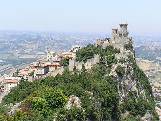
8. San Marino claims to be the world’s oldest constitutional republic – it was founded in 301 by a Christian stonemason fleeing persecution under Emperor Diocletian. Its constitution of 1600 is the oldest written constitution in the world. San Marino is pictured above.
9. Though Mt. Everest is the highest altitude in terms of sea level on the planet, Mount Chimborazo is the closest to the moon. The Marianas Trench is the lowest place on earth.
10. Alaska is the most Northern, Eastern, AND Western state in all of America. It is the only state that enters the “Eastern Hemisphere” making it also the most eastern lying and western lying state.
11. The Mid-Atlantic Ridge is the Longest mountain chain on earth (at 40 thousand kilometers). It is located along the middle of the Atlantic. Iceland is the only part of this chain that is above water. The Andes form the longest exposed mountain range at 7,000 kilometers.
12. Mount Circeo on Cape Circaeum on the western coast of Italy was once called Aeaea (5 vowels in a row with no consonants). It was believed in mythology to be the home of the witch Circe. Two other vowel-only geographic locations are the town of Aiea in Hawaii, and Eiao – one of the Marquise Islands.
13. Glaciers store between 70% and 80% of all the freshwater on the planet. 99% of those glaciers are in the Arctic and Antarctic.
14. In 1811 and 1812, three earthquakes measuring around 8 on the richter scale, caused the Mississippi River to flow backwards. These earthquakes also created Reelfoot Lake in Tennessee.
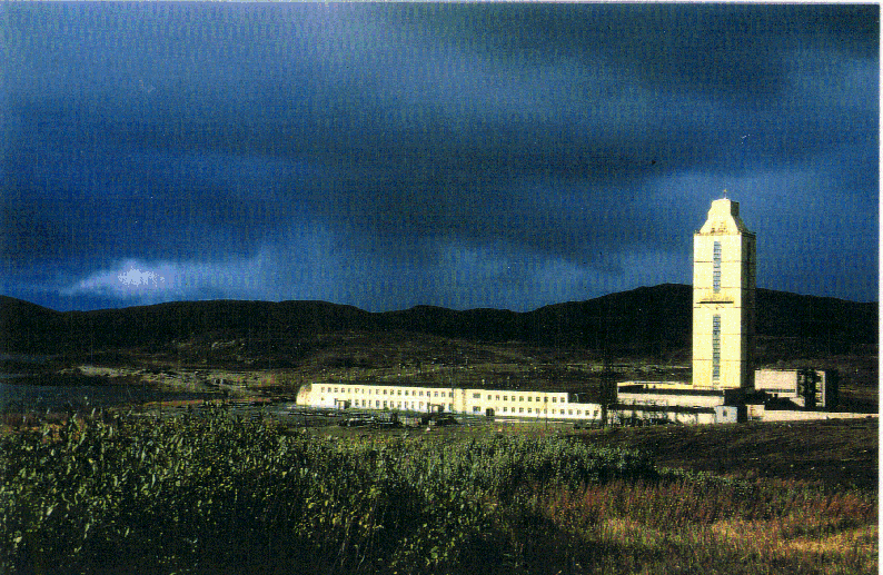
15. The deepest hole ever drilled by man is the Kola Superdeep Borehole, in Russia. It reached a depth of 12,261 meters (about 40,226 feet or 7.62 miles). It was drilled for scientific research and gave up some unexpected discoveries, one of which was a huge deposit of hydrogen – so massive that the mud coming from the hole was “boiling” with it. The borehole is pictured above.
Contributors: Schiesl, JFrater


Oooooh, I like the sky in the new pic.
This is another fun/interesting list.
Thanks Jamie for ListVerse, it’s part of my daily routine.
38. Bongo Mongo
Also ’segue’ you are a n00b. It is Mariana Trench.
****
Mariana Trench – Wikipedia, the free encyclopedia · Nature
The Mariana Trench (*or Mariana’s* Trench) is the deepest part of the world’s oceans, and the deepest location on the surface of the Earth’s crust. …
****
#54. Cedestra
Oh, and Bongo Mongo, segue may have gotten that fact wrong but you’re an *****.
****
Thank you, Cedestra, I couldn’t have said it any better!
#10 – it’s so far west it’s east… deja vous…
Went to bed last night (really, really late) telling my husband about the photo for item 15. Then when I got up to show it to him today find that it has been updated to a more accurate photo. Accuracy vs. interesting. In this one particular situation I vote interesting but respect accuracy.
Is there a link to the original photo post so I can share it with him. It is so surreal, it reminds me of old record album covers.
Contributors: JFrater
Well, I wasn’t expecting that.
nice list
`¬` this.: I included it because I added 5 items to a submitted top 10 to make it 15
Deziner: click here for a large array of pictures of the original (Mirny Diamond Mine). Amazing.
@52 apepper: You are right mostly but the fact that you lose one piece of information when you do not mention that it is “closer to moon”. Its a matter of 3D perspective that, for example, any point on the line (extend it to infinity) connecting center of earth to the poles is still farther to the moon than any point on the equator no matter what distance it has from the center. Of course this example ignores the properties of lunar orbit in its truest sense.
In simple terms projection of Mt. Chimborazo in the direction of the line through the center of Earth and Moon (on the orbital plane) is farther than that of Mt. Everest on the same line from the center of Earth.
Cool list by the way, knew most of them and glad to know the ones I didn’t
I didnt realise the Vatican City was its own country!! haha
Great list.. learnt heaps!
Its not! It is subject to Italian law.
Great list guys.
Anyone up for a quick game of “who can say the longest place names the fastest”?
great list! i didnt know most of these
In terms of “height from base”, Mauna Kea in Hawaii is taller than Mt. Everest, as measured from the ocean floor.
In other words, if the whole of Mauna Kea was placed above water, it would be taller than Everest.
from wiki:
Mauna Kea = about 33,000 ft. as measured from ocean floor.
Mt. Everest = 29,029 feet measured from earth’s surface.
The Mid-Atlantic Ridge has a length of 40000km? That is greater than the circumference of the Earth (assuming the Earth is a sphere – I know it’s not), and a cursory glance of a couple of encyclopaedias and researcher’s web pages give values ranging from approximately 10000km to 16000km. Was your source wikipedia? If so the length of 40000km is not just for the Mid-Atlantic Ridge but is of a greater structure comprising ridges in more than just the Atlantic.
74. copperdragon
In terms of “height from base”, Mauna Kea in Hawaii is taller than Mt. Everest, as measured from the ocean floor.
****
I’ve read that before, and thought it was rather unfair for Mauna Kea . But then, so many things are unfair.
wow this stuff is so cool.
Re: no. 11
Iceland also marks the place where the North American tectonic plate is being created. The Mid Atlantic Ridge is a spreading zone where hot magma bubbles up due to mantle convection. The San Andreas fault in California marks the place where the North American plate is being subducted and recycled back into the earth. It’s pretty cool to think about the distance and time involve the the whole process if you’re a geology nerd like me. Consider: California used to be where Iceland is now. Crazy.
Re: no. 10
Way cool. For reals.
Re: no. 14
Sorry, more geology nerdiness. This happened on the New Madrid fault right around the middle of the continent. This fault is an aulacogen, the failed arm of a triple junction of a plate tectonics rift system. These are quite common around the world. Basically, here the continent tried to tear itself in half and failed. Sometimes the fault acts up and causes earthquakes such as the magnitude 5.2 earthquake in Illinois on Fri. April 18 2008.
I got it from various sources. Mostly from Books and random knowledge i attained in Geography class haha. That fact i Believe was added by JFrater, but i could have thrown it in there, i honestly forget haha.
@ 72 PirateXxEsque
“Anyone up for a quick game of “who can say the longest place names the fastest”?”
Should be pretty easy in the case of Bangkok (No.1 on the list), considering the name itself IS used as a song lyric.
78. mariposa, I live where the Pacific Plate is being subducted by the North American Plate.
I can see it. I have taken photos of it. I walk it daily.
It’s both beautiful and amazing.
Actually, I forget at the moment which plate subducts which, but I’ve already taken my nighttime meds, so looking it up is outside the bounds of my abilities.
awesome list…i can add these to my notes..hehehe..tnx..
Jamie, you should remove the first photo, to reflect the text for #4! hahahaha!!
astraya: heh – I think we might be the only ones that would get the joke
Time for some semi-serious comments.
Are #1 and 3 meant to be written with gaps in them? It’s hard to say that they are “the longest” if they’re actually separate words. If these classify as “one word” in Maori, Thai and Welsh, then why don’t all Maori, Thai and Welsh sentences count as one word?
#2 In a sense, East Timor is also surrounded by one country.
#3 Does anyone know the pronunciation of this? I’m assuming “Ah”, but the diacritic may make a difference.
#8 The traditional date of the founding of San Marino is 3 September – today (at least where I am). (I saw that on wiki – I didn’t know that from memory.)
#10 Alaska is “east” only according to the arbitrary choice of Greenwich Observatory as the prime meridian. If, say, Korea had been the Top Nation at the time the prime meridian was chosen, and it arbitrarily passed through Cheomseongdae Observatory, Gyeongju, Alaska would lie entirely in the “eastern” hemisphere. (As an Australian, I would also add that there’s no reason for north to be “up”, except that the first mapmakers lived in the north, so got to be on top (so to speak).
#15 Did you change the photo for that? Previously, there was a hole there. Now there’s a building. I was going to say “I hope they built a fence around that hole!”! What is the building, anyway?
Forget that last question. I’ve just read the previous comments. (I should do that first, anyway.)
schiesl, you’re right
hahaha i got that astraya. when looked at the right way, that photo is very dirty
Goddamn, I’m good
schiesl: You may be thinking something else than I am thinking. I am thinking: “People steal the sign, so let’s ‘steal’ the photograph”. You seem to be thinking: “This sign looks like something else”. I’m squinting at it, and can’t discern “something else” other than a stylised woman without arms in a long dress, standing with her legs apart, but that’s hardly “very dirty”. Please explain. I’m missing something.
eh i just have an over active imagination. i see something that i can not say in a public setting.
astraya: they are still the longest – that includes ALL cities, countries, etc. with names which are a sentence. They are not noted for being incredibly long words – they are noted for being incredible long “official” names for something
Great list J, nice to Western Australia gets mentioned, the only way to describe it during summer here is F#@&%*! boiling.
even going to the beach gives no releif, by the time you get out of the water, get your towel and get back to the car, you already want to get back in the water but the sands too bloody hot to walk back across
Change subject completely: There are four national capitals that, in English, have one syllable – Rome, Prague, Berne and Seoul. In the local languages, at least three have two syllables – Roma, Praha and Seo-ul (though it’s pronounced as one). Berne is problematic, being one syllable in some of Switzerland’s languages, and two in others.
CRSN:
I hate when I go swimming in summer (in QLD) and the seawater is warm and the sand is burning hot. Swimming in winter is nice though
Actually, the shortest name I ever heard of for a town is the one of a french village called “Y”…
It should even be considered shorter than #4 since there is only a letter and no diacritic sign “°”…
And just for the fun of it, another geographical oddity: did you that the country with which France has the longest terrestrial border is…….. Brasil !!!
Yes… French Guiana is a french “département”, therefore a part of France, and its border with Brasil is longer than any other border France has with its neighbours.
Tempyra – the east coast is so much better for beaches, i couldnt believe it when our family first moved over to WA, i was used to the sand bars going out for 20 odd meters to the waves and thats how i learned how to surf, but when we moved to WA i found that all the waves broke right on the beach, you can go up or down the coast and find better, but on a stinking hot day you just want to get to the closest beach and the ones near Perth are crap, as soon as you walk into the water you fall into a ditch and get smacked over the head with a wave, swim out that 20 meters or so and there are no bloody waves, i swear that WA is the backwards state in so many ways.
personally, my favorite all round beach is Belongil beach in Byron Bay, it goes for ever, theres a pub right on the beach, crystal clear water with nice waves and the locals are great.
My brothers and I call Byron the Festival of the Flesh, everyone walks around town in their bathers most of the time.
J- WTF is the deal with that poo stuff? what like poo spam, that could get messy
CRSN:
Belongil was nice; I’ve only been there once though. Most of the beaches I’ve seen on the east coast are all long sandy beaches – good for surfing I guess. I like little bays with rocks and seaweed and fish and things to look at, like the east coast beaches in NZ (yes, I’m biased). Some of the west coast beaches in NZ (I’m thinking of Bayleys beach) are like how you describe WA beaches though… except colder
Tempyra – so you’ve probably seen that god awful soap show in Australia called “Home and Away”, the show is ***** but the beach and the bay that they film in is beautiful, thats were i grew up and surfed, the main beach where they film the surfing and swimming scenes with the light house on the head land is called Palm Beach and over the other side, the bay is called Pit*****er Bay.
A lot of these beaches have head lands protecting them and are really interesting to explore, it was one of the really popular areas for the art movement out of Sydney during the late 60′s, if you go for a walk past the pools carved/built into the cliffs you will find the odd rock that has been carved out by an artist, a lot of them are of local aboriginal tribe leaders because the artist wanted to leave something that pertained to the area and its history that survived.
I’ve even come across a carved rock that has the image of Jesus, the story behind that was supposedly a Spanish family had moved to the area in the late 50′s and had a rough time starting out, family sickness, jobless and just plain down on their luck, they were a very Religious orrientated family and prayed for their luck to be changed and their family blessed, when they finally had success the mother was struck by a car and died, the family went back into a depressive state and really just didnt bother anymore with anything, the youngest boy had always drawn inspiration from his mothers prayers and how hard she had worked to get the family to where they were, so he carved a rock in the form of Jesus’ face as an honour to her, always looking out to see awaiting her return.
pretty deep stuff eh?!
Re my 81., okay, I am awake after a good 7.5 hours sleep and I do remember that it is indeed the Pacific Plate being subducted by the North American Plate.
It’s amazing to be able to actually see this happening, or to see the effects of it, anyway since it all happens in geologic time, but the rock formations all around are astounding, going off in every conceivable direction, all within meters of each other.
Of course, this also means I live directly atop a fault zone, too, and almost all of the hills around us are old, worn down volcanos…the tide pools are made up of very old magma.
It’s interesting.
63. segue: I calls ‘em like I sees ‘em. You’re welcome.
that’s pretty cool list: Thanq Schiesl & Mr. Frater
I am actually make a note of such lists as my lessons so that if I never happen to go school… I am still learning something very important!!!
Thanq once again
Thanks for the link Jamie.
My husband was “properly” amazed.
#38 Bongo Mongo
What is a n00b? I have never encountered that word (?) before.
BooRadly: a n00b is a “newbie” – ie, someone new.
Obviously, Bongo Mongo is long gone, but he’ll be wrong forever.
Segue and CopperDragon:
Its a little known fact that Mauna Kea is the TALLEST mountain and Mt. Everest is the HIGHEST mountain.
Many people confuse these terms and its easy to see why. Tall refers to the ‘length’ and highest refers to the peak altitude.
You’ll see a whole lot more on top of Mt. Everest even if Mauna Kea is the tallest.
Think of a 7′ and a 5′ man standing on a 3′ table. The 7′ man is taller but the 4′ man is higher at an elevation of 8′.
_____________________________
As far as Mount Chimborazo being closer to the moon than Mt. Everest it might be easier to think of it like this:
Mount Chimborazo is closer to the equator which is roughly the path that the moon travels in orbit around the Earth.
If you could tie a string, say fishing line, to the peak of Mount Chimborazo and the peak of Mt. Everest and tie the other end to the same point on the moon, the string for Mt. Everest would be longer because its latitude above the equator is further North.
scheisl: If you saw a dirty picture in the photo at the top, try these – http://listverse.com/miscellaneous/top-10-worst-logos/
108. ¡¡ʞunɹp os ɯ,ı , yes, the relative closeness to the moon was apparent as soon as the “oddity” was pointed out, I immediately thought of the equator so that one was a no brainer.
But the tallest v. highest was confusing, until your explanation of “tallest” v “highest”. It really helped me.
So thank you.
I guess if San Marino was founded in the year 301, it would be older than 1700 years, not 1600 (actually it would be older than 1600, but also 1700), unless it stopped being a republic 100 years ago, or this article has been written a 100 years ago
…
In number 4 shouldn’t it be “replaced” instead of “replaces”.
Great site.
Re. 78. mariposa – “The San Andreas fault in California marks the place where the North American plate is being subducted and recycled back into the earth. It’s pretty cool to think about the distance and time involve the the whole process if you’re a geology nerd like me. Consider: California used to be where Iceland is now. Crazy.”
This is an oversimplification, and not precisely true. The San Andreas fault and the other faults that make up that complex are slip faults. The west coast of California is slowly heading north. That coast is, actually, on another plate entirely, the Pacific plate. There are no major subduction zones off California’s coast (except maybe a bit at the northern tip). There’s subduction off the Pacific Northwest, as the Juan de Fuca plate slowly disappears. But the North American plate is not being subducted.
Also, California never touched the Mid-Atlantic ridge. The land created by that ridge is mostly under the Atlantic ocean. The North American continent was created by a long, complex history, involving microcontinents smashing in, land created by volcanoes, and so on; it’s not easy to sum up. But California wasn’t born next door to Iceland.
In response to mregan, it is not technically correct that there is not a direct road connecting Missouri to Kentucky. Someone else said it, but Wolf Island Rd. is the only road that connects the two states. I have some additional info about it though. For those on Wolf Island road in Kentucky to get to the rest of the state (Kentucky), they have to travel quite some distance. They must travel north into Missouri about 45-60 minutes until they hit the Illinois border, then go east a few miles until they cross over into Kentucky (onto Swan Lake Rd. in Wickliffe, KY). The whole trip is about 35 miles and takes between 45-60 minutes. Quite the effort to get a KY driver’s license, vote in an election, etc. if you live on Wolf Island Rd. You have to cross into TWO states just to get back to your own!
#16. Reno is farther west than San Diego. (CA)
I think it’s amazing how the Hawaiian Islands were/are formed. All islands for that. To have to grow so tall to break water (you know what I mean
)Just fascinating.
astraya i saw all those, i have been to this site since probobly right after it was formed, i believe there where only 10 lists or so when i first found this. That happened to be one of my favorite lists, loved it. Thank you anyway though!
Angharad – I realize that what i said before was an over simplification. I don’t like to go into great geological detail unless I’m around people who are actually interested. I’ve found that people’s eyes tend to glaze over when I do.
nice
@80 Massoluk
you can also learn the New zealand one from this video
Though the song has a bit added to the word to make it fit the tune