 Weird Stuff
Weird Stuff
Weird Stuff  Mysteries
 10 Tragic Disappearances and Deaths in Joshua Tree National Park
 History
 10 Ways Childhood Really Sucked in the Old West
 Music
Music 10 Name Origins of Famous Bands from the 1990s
 Religion
 10 Biggest Turnarounds by the Catholic Church
 Weird Stuff
 10 Unbelievable Times Laws Had Unintended Consequences
 Humans
 Ten Historic Women Who Deserve Way More Credit Than They Got
 Movies and TV
 10 Films That Spawned Major Lawsuits
 History
 Ten Times Towns Were Wiped Off the Face of the Earth
 Creepy
 10 of the Most Disturbingly Haunted Public Houses in the UK
Weird Stuff 10 Niche Subcultures That Are More Popular Than You Might Think
Mysteries 10 Tragic Disappearances and Deaths in Joshua Tree National Park
History 10 Ways Childhood Really Sucked in the Old West
Who's Behind Listverse?

Jamie Frater
Head Editor
Jamie founded Listverse due to an insatiable desire to share fascinating, obscure, and bizarre facts. He has been a guest speaker on numerous national radio and television stations and is a five time published author.
More About Us
Music 10 Name Origins of Famous Bands from the 1990s
Religion 10 Biggest Turnarounds by the Catholic Church
Weird Stuff 10 Unbelievable Times Laws Had Unintended Consequences
Humans Ten Historic Women Who Deserve Way More Credit Than They Got
Movies and TV 10 Films That Spawned Major Lawsuits
History Ten Times Towns Were Wiped Off the Face of the Earth
Creepy 10 of the Most Disturbingly Haunted Public Houses in the UK
10 Worst Earthquakes From The Past
This list is in chronological order and is neither exhaustive nor definitive; it describes events where there is plenty of historic evidence and research rather than for magnitude size or human loss. Where possible I have used the Moment Magnitude scale (MMS) to give a destructive measure with seismic maps from Wikipedia; where no seismic map is available a general map of the area has been used. I have used various geology resources to update my own knowledge of specifics as it was 10 years out of date.
Historic earthquakes are actually very important to determine the likelihood of a massive natural disaster occurring in the same region again and under what sort of timeframe. Unfortunately it seems that the human mind tends to forget quite quickly about a destructive event such as an earthquake or simply manages to put it out of mind, this will be demonstrated in this and subsequent lists where natural disasters that are still fresh in our minds occurred in the same vicinity on several previous occasions. Even after many years of study I still find it incredulous that we rebuild our cities in seismically active areas after such a destructive event.
10
Mount Tai Earthquake
1831 BC
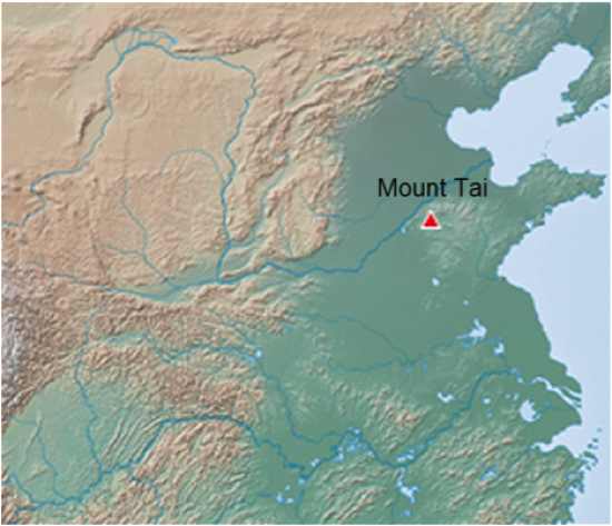
While very little is known of this earthquake, it holds the distinction of being the first written account of an earthquake and natural disaster. It holds this distinction as it is mentioned in the Bamboo Annals which chronicles ancient China.
There is no loss of life mentioned within the Bamboo Annals and it occurred at Mount Tai during the 7th year of reign of King Fa from Xia dynasty in what is today China’s Shandong province.
Mount Tai is one of the Five Great Mountains within Chinese culture and is associated with sunrise, birth and renewal.
Seismically Mount Tai is a tilted fault-block mountain with height increasing from the north to the south. It is the oldest example of a paleo-metamorphic formation from the Cambrian Period in eastern China known as the Taishan Complex.
Shandong is one of the more seismically active areas of modern day North Eastern China and is situated close to the epicenter of the Tangshan Earthquake of 1976; itself preceded by a moderate earthquake in Miaodao in Shandong Province in 1975 and the area is frequently subjected to earthquakes of magnitude 6 or more.
9
Sparta Earthquake
464 BC
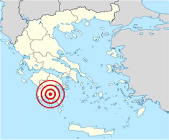
This earthquake had far reaching consequences and destroyed much of the city state of Sparta. It has been estimated that the quake and its after effects may have killed as many as 20,000 people and it sparked the revolt of the Helots. This revolt led to a breakdown of a treaty between Sparta and Athens which led directly to the First Peloponnesian War.
The events that have survived in the writings of Strabo, Pausanias, Plutarch and Thucydides are attributed various reliability and thus it has been difficult to pinpoint the exact epicenter and magnitude associated with the quake.
The earthquake contributed to a growing distrust between Sparta and Athens. Thucydides, the ancient Greek chronicler of the Peloponnesian War, reported that a number of Greek city-states sent troops to help put down the rebellion of helots in Sparta. Athens sent approximately 4,000 hoplites under the leadership of Cimon, but this contingent was sent back to Athens, while those from other cities were allowed to stay. According to Thucydides, the Spartans were concerned that the Athenians would switch sides and assist the helots. The Athenians were insulted, and therefore repudiated their alliance with Sparta. Once the uprising was put down, some of the surviving rebels fled to Athens, which settled them at Naupactus on the strategically important Corinthian Gulf. The alliance would never be revived, as disagreements between Sparta and Athens would continue to intensify until the outbreak of war in 460 BC. Given that the Helot population seized upon the earthquake to rebel against the Spartans, the Spartans reformed their society after the Helots were subdued, becoming extremely austere.
The Spartan area of Greece has been subject to many recent earthquakes including the 2008 Peloponnese earthquake located less than 50km from the 464 BC area of most destruction. Seismically, Greece sits on the plate boundaries of the Eurasia, Africa and Arabia plates which have produced still smaller micro-plates that sit under Greece. It is likely that a strike/slip fault, which has east-trending and northeast-trending zones of deformation and which moves at the rate of about 30mm per year was the cause of the Sparta quake.
As an addendum to this earthquake during the later Peloponnesian Wars the Greek historian Thucydides described a tsunami that occurred in 426 BC, and he was the first to associate the cause of a tsunami with an earthquake in a written account. The epicenter of this quake is as yet undiscovered, however evidence points at a crustal movement along one of the faults in the Euboean gulf, rather than submarine landslides, thus Thucydides conjecture via his research into the cause of the tsunami shows remarkable intuition given that he was not party to the actual quake responsible.
8
Rhodes earthquake
226 BC
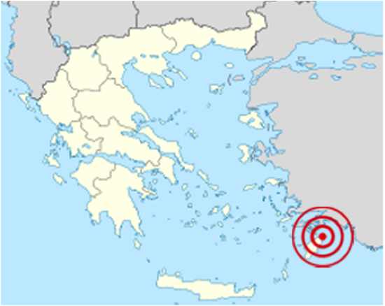
Historically significant for destroying the Colossus of Rhodes and the city of Kameiros on the island of Rhodes.
Rhodes has been culturally and commercially important as a trading post for many thousands of years as it lies close to the Asia Minor, Middle Eastern and African trade routes. As a major Aegean port city at the time of the earthquake, it shared this distinction with another famous earthquake casualty Alexandria in Egypt.
The Colossus of Rhodes was primarily built and given in thanks to the Greek Gods for helping Rhodes defend a Macedonian siege and as Rhodes grew in stature it became a very rich trading city of the Mediterranean Sea allowing the hubris of building the Colossus to show off its wealth.
However far from protecting the city the statue likely stood for less than 30 years after its completion and rather ignominiously, after this quake, the Colossus was left to rot in the harbor of Rhodes for some eight centuries before it was sold by Arab invaders to a Jewish merchant in Edessa.
Due to its economic importance and its cultural significance Rhodes was perhaps the first example of aid being delivered to a city/country by many parties. Several other city states lent assistance and aid and even Ptolemy III of Egypt offered to fund the rebuilding of the Colossus (which was deemed not to be rebuilt by an oracle).
As the previous entry, Rhodes is part of the plate tectonics of the Mediterranean Sea and specifically lies on the boundary between the Aegean Sea and African plates. This is one of the more complex seismic zones of our world as there is thrusting, extension and strike slip faulting and the island is undergoing a counter-clockwise rotation due to these stresses. Apart from these stresses the island has also been subjected to being tilted to the Northwest in the Pleistocene.
7
Lydia Earthquake
AD 17
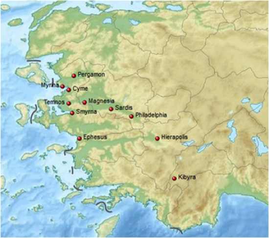
One of the most destructive single events in Roman times which virtually wiped out trade to Asia Minor (modern day Anatolia).
The earthquakes were reported by the Roman historians Tacitus and Pliny the Elder, and the Greek historians Strabo and Eusebius. Pliny called it ‘the greatest earthquake in human memory.’
At least 12 cities were destroyed by this quake and it is estimated to have had an epicenter near Ephesus, Sardis or Magnesia. Sardis, Magnesia, Temnos, Philadelphia, Aegae, Apollonis, Mostene, Hyrkanis, Hierapolis, Myrina, Cyme, Tmolus, Pergamon, Ephesus and Kibyra were all at least partially destroyed. However, of these only Pergamon, Ephesus and Kibyra are not mentioned by Tacitus. Reports of the destruction of Ephesus may be attributed to a further quake which struck the region in 23 AD.
Adding to the disaster and loss of life, the 17 AD earthquake occurred during the night and was of such economic magnitude that the Roman Emperor Tiberius sent an aid package of at least 10million sesterces to Sardis alone to counter the problems associated with the quake. Rome decreed that all cities affected by the quake would pay no taxes for five years after the quake to allow an economic recovery, however Sardis never fully recovered from the disaster and, being the former capital of the Lydian Empire, probably dealt a final blow to the remains of that empire.
Conversely because of these aid packages it is also one of the first recording instances of people/groups creating scams and frauds to access the funding on hand, with reports by Roman historians of ships being sailed out to sea, painted and renamed with the original ship owners asking for aid in replacing their lost vessels.
Seismically the area is affected by the Dead Sea Transform system, the Northern Anatolian Fault, the East Anatolian Fault, the Red Sea Rift and interactions with the Arabian, African and Eurasian plates.
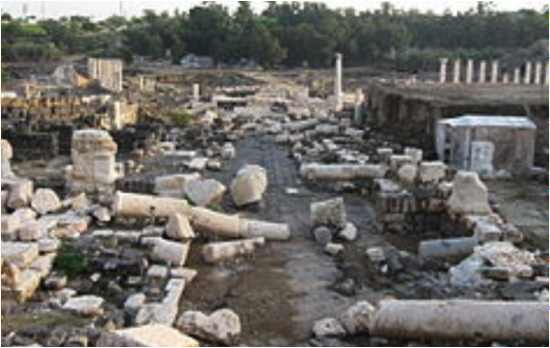
6
Antioch Earthquake
115 AD
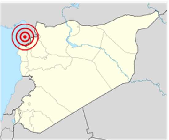
This may become a theme as this area of Anatolia has been subjected to many violent earthquakes and has been a hub of human civilization for many thousands of years.
Antioch lies to the Southeast of modern day Turkey and is quite literally sat atop a plate transform boundary between the triple junction of the northern end of the Dead Sea Transform, the mainly transform boundary between the African Plate and the Arabian Plate and the southwestern end of the East Anatolian Fault. It sits in the Anatakya Basin, part of the Amik Basin, filled by Pliocene-to-recent alluvial sediments making it particularly susceptible to ground movement and liquefaction.
You will hear more about Antioch as these lists progress as some of the most devastating earthquakes and loss of life have occurred in and around this area of the world.
The 115 AD quake took place on the 13th December 115 AD. At an apparent magnitude of 7.5 on the Moment Magnitude scale (MMS), the quake shows how ground setting is vitally important in all earthquake studies as, while large, it is not in the megathrust territory of magnitude yet its placement on an alluvial plane compounded the ground shaking to devastating effect.
This earthquake is particularly well recorded as the then Roman Emperor Trajan and his successor Hadrian were caught in the earthquake and its aftermath, giving us their perspective as their scribes described the events that took place.
The most vivid account comes from the writer Cassius Dio in his Roman History, stating that Antioch was filled at the time of the quake due to the Emperor overwintering within the city. Therefore there were many traders, civilians and soldiers following the emperor’s journey and Cassius Dio paints a vivid picture of the destruction he witnessed. This included a far off roaring just prior to the quake, violent ground waves during the quake with trees being uprooted and thrown in to the air, soldiers and civilians killed by falling debris, watching the attempted rescue of people trapped in collapsed buildings and the aftershocks of the quake adding more fear and increasing the death toll along with watching the trapped individuals dying of starvation.
In addition to Antioch, the city of Apamea was also destroyed by the earthquake and Beirut suffered significant damage. Adding to the devastation on land, a tsunami was generated by the quake which inundated the Lebanese coastline and likely destroyed the harbor at Caeserea Maritima. In total 260,000 are said to have died during or in the aftermath of this event.
5
Crete Earthquake
365 AD
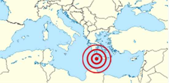
An undersea earthquake struck off the coast of Crete on the morning of 21st July 365 AD. The quake is estimated to be at least of a magnitude 8 on the Moment Magnitude scale (MMS) and was followed in quick succession by tsunamis that destroyed many parts of the Eastern Mediterranean Seaboard, particularly devastating central and southern Greece, northern Libya, Egypt, Cyprus and Sicily. In Crete, nearly all towns and settlements were destroyed. The tsunami generated by the event had far-reaching effects on Libya, the Nile Delta and Alexandria with some reports stating that ships had been hurled up to 3km inland.
This event seems to have been the largest in an earthquake swarm that hit the area and evidence has been mounting in recent years that a cluster of quakes hit the region between the 4th and 6th centuries AD.
As a result of the tremendous force unleashed by the quake the whole of Crete was uplifted by 9 meters and may actually have caused the reactivation of many surrounding plate boundaries leading to further quakes in the area. This quake would also seem to be larger than any modern day equivalent quake giving credence to a pressure build up at lower depths within the crustal zones surrounding the quake site. The source of the quake is the Hellenic Trench and recent studies strongly suggest that a quake of this magnitude happens every 5,000 years or so.
This earthquake is significant as it comes just on the cusp of the end of the Roman Empire and the emergence of the Christian faith as the most powerful Western religion. Therefore many reports on the quake are suspect as the writings are complicated by various tendencies to describe natural disasters as divine responses/interventions or warnings to political, material or religious events. As the old religions of paganism started to become marginalized, antagonism towards the Christian religions grew, writers on both sides distorted the evidence to fit their particular dogma leaving only a partial record in many Christian dominated areas.
The Sophist Libanius and the church historian Sozomenus appear to conflate the great earthquake of 365 AD with other lesser ones to present it as either divine sorrow or wrath, depending on their viewpoint, for the death of Emperor Julian, who had tried to restore the pagan religion, two years earlier.
However, and luckily, we do not just have these viewpoints and there are numerous references to the earthquake from other sources including Kourion on Cyprus, for example, which is known to have been hit by five strong earthquakes within a period of eighty years, leading to its permanent destruction in the 365 AD event.
This earthquake is also significant for the first documented and accurate description of how a tsunami reacts. It is the first written account to distinguish and describe the three phases of how a tsunami is generated; the report links the initial earthquake, the sudden retreat of the sea and the ensuing gigantic wave rolling inland. This was described by a Roman historian called Ammianus Marcellinus who gave us the date and time of the events and who seems to have not been subjected to the religious infighting between the Pagans and Christians of the time.
As a matter of respect and to commemorate the event the city of Alexandria held an annual event known as the “day of horror” until the 6th century AD.
4
Antioch Earthquake
526 AD
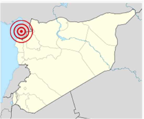
After just four centuries from the previous large quake we are back to Antioch and another massive earthquake which devastated the region. The previous quake in 115 AD killed approximately 260,000 people, this event killed at least a further 250,000 people. Here then is a prime example of hubris getting the better of knowledge. Half a million people killed in just over 400 years at the exact same place and using the exact same building materials.
The quake struck between May 20th-29th 526 AD and is estimated to be above a magnitude 7 MMS. The destruction was heightened by a fire caused by the quake which destroyed most of the city.
As with many large earthquakes the area was hit by many aftershocks over the next year and these were large enough to cause severe damage, including one large enough to uplift the port of Seleucia Pieria by up to 1 meter.
The quake destroyed many significant buildings including the Domus Aurea built on an island in the Orontes River, reports suggest that only houses built in the shadow of the mountain behind Antioch harbor survived intact. Amongst the many victims was Euphrasius the Patriarch of Antioch, who died by falling into a cauldron of pitch being used by wineskin makers, with only his head remaining unburnt.
The rebuilding of the Great Church and many other buildings was paid for by Justin 1st of Constantinople and was overseen by Ephraim, the comes Orientis, whose efforts saw him replace Euphrasius as the Chalcedonian Patriarch of Antioch, however in a stroke of what can only be described as a run of bad luck (or perhaps irony if you are of the atheist persuasion) many of the recently restored and renovated religious and government buildings in Antioch paid for by Justin were destroyed by another major earthquake in November 528 AD, although there were far fewer casualties.
3
Beirut Earthquake
551 AD
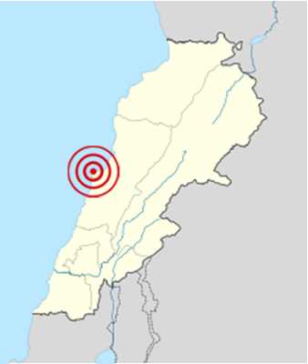
And again here we are back in Antioch’s neighborhood and a tectonic setting that encompasses the Dead Sea Transform (AKA Dead Sea Rift), which forms part of the boundary between the Arabian Plate and the African Plate.
In Lebanon the fault zone forms a restraining bend associated with a right stepping offset of the fault trace. Transpressional deformation associated with this bend has formed a number of thrust faults, such as the recently identified Mount Lebanon thrust, which underlies the city and is interpreted to crop out at the seabed offshore.
The quake occurred on the 9th July 551 AD and had an apparent magnitude of at least 7.6 MMS. As with many offshore quakes, a tsunami was generated by the thrust in the ocean which destroyed much of the Phoenician coastline and many of the ships used for trade within Phoenicia. The death toll has been estimated to be in the high 30,000s with one report by Antoninus of Piacenza giving that figure for Beirut alone.
The offshore fault likely ruptured for a length of approximately 100km (though some reports suggest an even greater distance of 150km) making the tsunami generated particularly large and the quake was felt from Alexandria to Antioch.
An interesting fact is the recently discovered Mount Lebanon thrust ruptured and caused the tsunami and this has been verified and is consistent with quaternary uplift recorded by a series of marine-cut terraces between Tripoli and Beirut proven by a continuing upward movement of the hanging wall of the proposed thrust. At a smaller scale, an uplifted vermetid bench, which indicates vertical movement of about 80cm, is dated to the sixth century A.D corroborating this earthquakes epicenter and likely cause of the tsunami. Continued uplift above this thrust since the late Miocene Era may explain the formation of the Mount Lebanon range.
2
The Seventh Earthquake
749 AD
Here we have another strong earthquake on the Dead Sea Transform fault that has little written evidence and which has been muddied by reports blaming the event on God for various reasons.
This earthquake struck an area between Palestine and Jordan, likely centered on the Golan Heights on January the 18th 749 AD; it is estimated to be well over a magnitude 7 quake. It is another interesting example of how little actual science and reporting was allowable under the various religious doctrines of the time and the suppression of all else save for relating every major occurrence to the wrath of God.
The earthquake destroyed the cities of Tiberias, Beit She’an, Hippos and Pella and they were left largely uninhabitable while many other cities across the Levant were heavily damaged. In addition, the earthquake reportedly claimed many tens of thousands of victims.
The value of the reporting can be summed up by the following two reports: A Coptic priest from Alexandria reported that support beams had shifted in houses in Egypt and a Syrian priest wrote that a village near Mount Tabor had “moved a distance of four miles.” Reliable reports these are not.
Other more reliable sources reported tsunamis in the Mediterranean Sea, several days of aftershocks in Damascus, and towns swallowed up in the earth including some destruction at Jericho. The death toll in Jerusalem numbered in the many thousands. Many buildings, among them the Al-Aqsa Mosque, were severely damaged. The town of Umm el Kanatir and its ancient synagogue were destroyed. There is also growing evidence that the quake produced a tsunami likely caused by an undersea landslide generated by the quake rather than directly from an upthrust below the ocean.
Of more serious consequence; this fault poses a significant threat as the fault zone has experienced strong earthquakes which were recorded in 31 BC, 363 AD, 749 AD and 1033 AD, giving a periodicity of about 350 to 400 years. This would indicate that the area is well overdue for another quake and the strain over that near one thousand year period might unleash a substantially larger quake that the 749 AD event.
1
Damghan Earthquake
856 AD
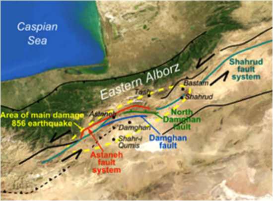
As many are aware, Iran has suffered some of the most devastating earthquakes in modern times. However most of these pale in comparison to this earthquake which occurred on the 22nd December 856 AD.
The earthquake had an apparent magnitude of 7.9 and at least 200,000 people were killed in the quake itself, this was compounded by the surrounding geology which magnified the meizoseismal area (area of maximum damage) which extended for about 350km along the southern edge of the eastern Alborz mountains of present-day Iran including parts of Tabaristan and Gorgan.
The earthquake’s epicenter is estimated to be close to the city of Damghan, which was then the capital of the Persian province of Qumis. It is listed by the USGS as the sixth deadliest earthquake in recorded history. Many aftershocks happened in this region after the major quake and continued for several years with one exceptional aftershock centered in western Khurasan causing more destruction.
Iran lies within the complex zone of continental collision between the Arabian Plate and the Eurasian Plate, which extends from the Bitlis-Zagros belt in the south to the Greater Caucasus mountains, the Apsheron-Balkan Sill and the Kopet Dag mountains in the north. The epicentral area is located in the Alborz mountain range, in which oblique north-south shortening is accommodated by a combination of thrusting and sinistral (left-lateral) strike-slip faulting.
Again this is an area of intense study and the fault zone which caused this quake, the Astaneh Fault System, would seem to have a roughly 3,700 year periodicity.
Damage occurring along the Alborz included the towns of Ahevanu, Astan, Tash, Bastam and Shahrud, with almost all the villages in the area severely damaged or outright destroyed. Hecatompylos, now called Šahr-e Qumis, the former capital of Parthia, was destroyed and totally abandoned after the quake. Half of Damghan and a third of the town of Bustam were also destroyed.
More Great Lists
 10 Dangerous Health Fads And Medical Treatments Used…
 10 Gross Cosmetic Products Of The Past
 10 Shocking Facts About Angola Prison And Its Violent Past
 10 Times Bones Gave Rare Glimpses Into The Past
 60 Stunning Images of The Middle East That Will Make…
 Top 10 Deadly Pandemics Of The Past
 Top 10 Worst Instances Of Inflation
 10 Worst Crimes To Occur In A McDonald's
 10 Worst Unsolved Mass Murders In US History
fact checked by
Jamie Frater
More Great Lists