 Weird Stuff
Weird Stuff
Weird Stuff  Mysteries
 10 Tragic Disappearances and Deaths in Joshua Tree National Park
 History
 10 Ways Childhood Really Sucked in the Old West
 Music
Music 10 Name Origins of Famous Bands from the 1990s
 Religion
 10 Biggest Turnarounds by the Catholic Church
 Weird Stuff
 10 Unbelievable Times Laws Had Unintended Consequences
 Humans
 Ten Historic Women Who Deserve Way More Credit Than They Got
 Movies and TV
 10 Films That Spawned Major Lawsuits
 History
 Ten Times Towns Were Wiped Off the Face of the Earth
 Creepy
 10 of the Most Disturbingly Haunted Public Houses in the UK
Weird Stuff 10 Niche Subcultures That Are More Popular Than You Might Think
Mysteries 10 Tragic Disappearances and Deaths in Joshua Tree National Park
History 10 Ways Childhood Really Sucked in the Old West
Who's Behind Listverse?

Jamie Frater
Head Editor
Jamie founded Listverse due to an insatiable desire to share fascinating, obscure, and bizarre facts. He has been a guest speaker on numerous national radio and television stations and is a five time published author.
More About Us
Music 10 Name Origins of Famous Bands from the 1990s
Religion 10 Biggest Turnarounds by the Catholic Church
Weird Stuff 10 Unbelievable Times Laws Had Unintended Consequences
Humans Ten Historic Women Who Deserve Way More Credit Than They Got
Movies and TV 10 Films That Spawned Major Lawsuits
History Ten Times Towns Were Wiped Off the Face of the Earth
Creepy 10 of the Most Disturbingly Haunted Public Houses in the UK
10 Impressively Odd Boundary Disputes
We tend to think of boundaries as permanent lines across the Earth. But that image is a lie. Just as a meandering river and the gradual shifting of the Earth can change a landscape, the invisible tide of geopolitics can ruin a perfectly good border. Sometimes, these changes can lead to war. Other times, they simply lead to incredibly odd disputes.
10Denmark And Canada’s Adorable Border War

Photo credit: Toubletap
In the pantheon of great border disputes, Denmark and Canada’s “conflict” over Hans Island would come somewhere near the bottom. A 1.3-square-kilometer (0.5 mi2) lump of rock in the Kennedy Channel, it lies almost equidistant between Canada and Denmark-administered Greenland. Since 1973, it has been at the center of one of the most adorable disputes in history.
Hans Island is of little strategic or economic value. As a result, Denmark and Canada aren’t overly concerned about staking their claims. The two countries routinely send soldiers to remove one another’s flags but do so in the nicest way possible. On the Canadian side, it’s traditional to leave a bottle of Canadian Club whiskey for the Danes. On the Danish side, it’s traditional to leave a bottle of schnapps and a sign saying “Welcome to Denmark!”
That’s not to say that either side would ever give up Hans Island. The two governments formally send one another letters of protest following incursions. But we’d rather concentrate on the image of cold, lonely soldiers exchanging hard liquor and friendly notes on the wild frontier.
9Greece And Macedonia’s Bitter Naming Dispute
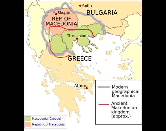
Photo credit: Future Perfect at Sunrise
In 1991, Macedonia declared its independence from Yugoslavia. The announcement triggered a furious reaction from the Greeks. Not because they opposed the breakup of Yugoslavia but because of something far more sensitive. They claimed Macedonia had stolen their name.
Before it became the name of a country, Macedonia was the name of a province in northern Greece. Before that, it was the name of an ancient kingdom that was famous for giving the world bisexual conqueror Alexander the Great. This is important because Alexander is kind of a big deal. Currently, both Macedonia the country and Macedonia the Greek province are claiming him on the basis of their names.
This has led to some serious consequences. For over a decade, Macedonia was subjected to a Greek embargo because Athens feared that the naming dispute could spark a deadly border war. In 2015, Macedonian Prime Minister Nikola Gruevski even said he was considering changing his country’s name to avert potential conflict. Likely candidates for a new name are Upper Macedonia and New Macedonia.
8Belgium And The Netherlands’ Jurisdictional Nightmare
New year, new border for Belgium and the Netherlands
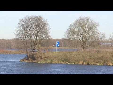
It sounds like the setup for a popular new Scandi-drama. A headless body is found on a tiny strip of land connected to the Netherlands but owned by Belgium. Belgian police are unable to easily land a boat there to investigate, and Dutch police can’t be seen to intrude on their neighbors’ territory. Cue the latest knockoff of crime drama The Bridge. Only this outline wasn’t a TV pitch. A few years back, it really happened.
The Belgian-Dutch border was set decades ago, partially running along the Meuse River. As time passed, the river wandered, cutting off Belgium from a tiny chunk of land it owned—land that was still attached to the Netherlands. With Belgian police unable to gain easy access and Dutch police unwilling to intrude, the peninsula became a haven for drug dealing and illicit sex. Then three years ago, a decapitated corpse turned up, and the whole thing became a jurisdictional nightmare.
If you’re expecting a gritty tale of competing national interests all wrapped up in a crime thriller, prepare to be disappointed. Like the sensible nations they are, Belgium and the Netherlands solved this problem in a supremely practical way. In December 2015, Belgium declared that they would simply give the peninsula to the Dutch. When asked why they were giving away territory, the Belgian mayor of border town Vise simply said, “It makes sense.”
7Finland And Sweden’s Lighthouse Maneuvers
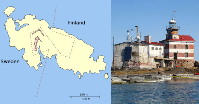
Photo credit: Oona Raisanen, tt_koski
In 1809, the Russian bear mauled Sweden in the Finnish War. As a reward for delivering a brutal smackdown, Moscow took possession of former Swedish colony Finland. A new border was drawn between the Aland archipelago and Sweden that just happened to cut right through the middle of tiny Market Island. At that point, things got complicated.
Half the island was technically owned by Sweden, but Russia treated the entire island as its own. In 1885, they threw up a lighthouse on the Swedish half, as if daring their old enemies to try something. When Finland gained independence in 1917, they got Russia’s half of Market Island and the illegally placed lighthouse.
Since the lighthouse was actually useful, neither side wanted to tear it down. But Sweden didn’t want to cede territory, either. In 1981, the two countries solved the problem by drawing the most contorted border we’ve ever seen.
Rather than go straight across Market Island, the new border starts in the middle and then swerves wildly to the Swedish side, putting the lighthouse in Finnish territory. It then swings sharply back the other way, giving Sweden an equal chunk of territory on the Finnish side. As an additional headache, the Swedish side is divided among two different counties, meaning you can cross one national and two local boundaries on Market Island with a single footstep.
6Nicaragua And Honduras’s Stamp-Based War
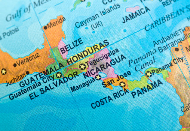
Of all the things to go to war over, you probably wouldn’t think a stamp ranked highly. Yet in 1937, a stamp design nearly triggered an apocalyptic war between Nicaragua and Honduras. The totally sane reason? Nicaragua’s design showed part of Honduras as the wrong shade of green.
Since their creation, the two nations had been locked in a protracted dispute about where their borders lie. Thanks to dense jungle and a history of failed settlements, deciding where to draw the line was remarkably difficult. An 1894 boundary commission could only agree on one-third of it.
It took until 1906 for the matter to be settled, when the two nations appealed to Spain, their old colonial master. King Alfonso XIII heard the arguments and promptly awarded a huge chunk of land to Honduras. For a long time, that seemed to settle the matter.
Then in 1937, Nicaragua released a new stamp. Featuring a map of Central America, it used light green for Nicaragua and dark green for everywhere else. The only problem was that it shaded a large chunk of Honduras in light green.
When news reached Tegucigalpa, riots erupted. A mob formed and nearly torched the Nicaraguan embassy. Both countries dispatched troops to the border, and it took the hasty combined efforts of Mexico, Costa Rica, and the US to avert an all-out war.
5Canada’s Pointless Lighthouse Keepers
Island of One: The Keeper of The Lighthouse
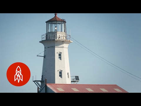
Denmark isn’t the only country fighting with Canada about borders. Machias Seal Island is a blasted lump of godforsaken rock that sits nearly equidistant between Maine and New Brunswick. Both the island and neighboring North Rock are useless in just about every sense of the word. Yet both the US and Canada lay claim to them. Shoring up those claims frequently involves going to ridiculous extremes.
One of the most ridiculous may be Canada’s pointless lighthouse keepers. In 1832, the British built a lighthouse on Machias Seal Island. Canada sees the continued presence of a lighthouse keeper as integral to its claim.
So every 28 days, a helicopter drops two lighthouse keepers out there to operate the light. Even though the light was automated decades ago, Canada wastes taxpayer dollars sending two completely superfluous guys to sit on a wind-lashed lump of rock for a month on the off chance that Obama might invade it.
One frequent suggestion is that the two countries should take their dispute to the International Court of Justice. But Canada contends that even to agree to arbitration would call their ownership into question, so the case remains unresolved.
4Migingo Island’s Fish-Based Insanity
Migingo: The Iron clad Island. The most densely populated island in Africa

Migingo Island in Lake Victoria is a mere 2,000 square meters (22,000 ft2), yet it houses over 500 people. That alone should tell you just how desirable it is. But it’s not just people who want in on its lucrative fishing waters. A decade ago, competing claims on this tiny lump of rock nearly sent Uganda and Kenya to war.
Ironically, just a few short years earlier, you couldn’t give Migingo away. Three hours by boat from Kenya and twice that distance from Uganda, it was considered utterly worthless.
As recently as 2002, only a single, eccentric fisherman was known to live there. Then the world got wind of his catch. In a part of the world where the average person may take home as little as $100 per month, the fisherman was hauling in enough to make over double that in a single day.
The news sparked a gold rush. People flocked to Migingo, setting up a makeshift shantytown. Shortly after, pirates moved in. The people appealed for help, and Uganda responded. At that point, things got ugly.
The majority of people on Migingo are Kenyan, and the islands were always thought of as Kenyan. So when Ugandan police flew a Ugandan flag, Nairobi got riled. Kenyan police went in to remove the flag, only to encounter 60 Ugandan Marines itching for a fight. In no time at all, a once worthless lump of rock propelled the region to the brink of war.
Luckily, the dispute has since been resolved. Migingo is now Kenyan, while Uganda stakes a claim to the surrounding waters.
3Australia’s Wandering Island
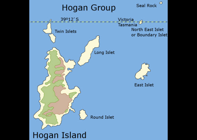
Photo credit: Graeme Bartlett
Not all boundary disputes involve two countries that are at each other’s necks. Sometimes, they can take place within a single country. Although the outcomes may be less warlike, the causes that triggered them can be equally bizarre. Such was the case with Australia’s North East Islet, part of the Hogan Group of islands.
Its 5 square kilometers (2 mi2) lie between Australia and Tasmania. It’s also monumentally dull. So lifeless and dull, in fact, that early cartographers forgot exactly where it was meant to be. In 1801, it was placed on official maps slightly north of its actual position.
When it came time to fix the boundary between Tasmania and the mainland state of Victoria, officials referred to the old maps. As a result, the boundary was accidentally fixed in a position that sliced right through the island’s heart.
When it was discovered that the island had been accidentally misplaced, officials scrambled to save face. They renamed North East as Boundary Islet, perhaps in the hope that their administrative screwup would seem intentional.
2The US’s Wandering State Borders
The Border War Georgia vs. Tennessee
Here’s something you may not be aware of: fixing borders is a tricky business. In 2010, Google Maps accidentally awarded a tiny patch of Costa Rica to Nicaragua, causing the latter to invade their neighbor. Natural landmarks and man-made monuments are necessary for marking borders to prevent confusion. But look at the borders of US states, and it becomes clear that we often have no idea where one begins and the other ends.
Consider Georgia and South Carolina. In the 18th century, it was decided that the Savannah River would serve as the official boundary. All well and good for a century or so, but rivers don’t stay still. They meander.
By 2000, the Savannah had meandered nearly a full kilometer from its original path. At that point, everyone began to argue about where the border truly lay. Was it where the river now ran or where it used to run? Resolving the dispute involved a survey team and likely cost thousands of dollars.
Some disputes are even stranger. Georgia and Tennessee originally fixed their boundary by use of a big boulder. Then one day, someone decided that the boulder had been moved, and all hell broke loose. Georgia said it should be in the middle of the river, giving them water access. Tennessee said that this was a “heinous assault on the sovereignty of Tennessee.” At the height of the madness, someone even stole the boulder.
Other state borders have also shifted over time or blurred completely. You might think that you know your home state, but its exact boundaries could be a mystery to everyone.
1India’s Uncountable Contested Borders
Border residents celebrate India-Bangladesh Land Boundary Agreement

In 2015, India and Bangladesh finally sorted out one of the craziest border disputes of all time. Following the Partition of India, tiny enclaves of each nation had been stranded within the other, containing around 50,000 people.
These weren’t just ordinary enclaves; some were enclaves within enclaves. Dahala Khagrabari was a piece of India completely encircled by a village belonging to Bangladesh, which was encircled by a strip of land belonging to India, which sat within the country of Bangladesh.
Some were even crazier. Panisala No. 79 was an Indian enclave in Bangladesh that was barely 0.27 acres and utterly useless. Thanks to tensions between the two countries, those inside these enclaves were often unable to leave and were denied access to basic services.
Thankfully, this mess was finally solved in 2015, giving all 50,000 people the right to choose their new nation. Most went for India. But this was just one of India’s insane border disputes. An uncountable number still remain active.
One of the wildest is the Chinese-Indian border. Both countries lay claim to huge chunks of territory that sit within one another. In some cases—like India’s claim on Aksai Chin inside China or China’s claim on the Indian state of Arunachal Pradesh—these claims are unlikely to ever go anywhere. But others involve a patchwork of towns and villages under split control that could spiral into a minor war at any time.
Then there’s the India-Pakistan border. From marshes to glaciers to mountains to bridges and roads (not to mention the entire province of Kashmir), the two states seem unable to agree on anything involving borders. And that’s before we even consider India’s disputes with Nepal and the Maldives. Although it may have sorted out its enclave issue with Bangladesh, India still has some of the most difficult borders in the known world.
More Great Lists


fact checked by
Jamie Frater
More Great Lists