 History
History
History  Food
Food 10 Weird Foods Inspired by Your Favorite Movies
 Religion
 10 Mind-Blowing Claims and Messages Hidden in the Bible Code
 Facts
Facts 10 Things You Never Knew about the History of Gambling
 Weird Stuff
 10 Cool and Creepy Facts about Collecting Tears
 Humans
 The Ten Most Lethal Gunslingers of the Old West
 Misconceptions
 10 Phony Myths and Urban Legends That Just Won’t Die
 History
 10 Amazing Roman Epitaphs
 Weird Stuff
 10 Niche Subcultures That Are More Popular Than You Might Think
 Mysteries
 10 Tragic Disappearances and Deaths in Joshua Tree National Park
History Top 10 Tragic Facts about England’s 9 Days Queen
Food 10 Weird Foods Inspired by Your Favorite Movies
Religion 10 Mind-Blowing Claims and Messages Hidden in the Bible Code
Who's Behind Listverse?

Jamie Frater
Head Editor
Jamie founded Listverse due to an insatiable desire to share fascinating, obscure, and bizarre facts. He has been a guest speaker on numerous national radio and television stations and is a five time published author.
More About Us
Facts 10 Things You Never Knew about the History of Gambling
Weird Stuff 10 Cool and Creepy Facts about Collecting Tears
Humans The Ten Most Lethal Gunslingers of the Old West
Misconceptions 10 Phony Myths and Urban Legends That Just Won’t Die
History 10 Amazing Roman Epitaphs
Weird Stuff 10 Niche Subcultures That Are More Popular Than You Might Think
Mysteries 10 Tragic Disappearances and Deaths in Joshua Tree National Park
10 Incredible Geological Oddities You Probably Haven’t Heard Of
Mount Everest? Surely, you’ve heard of it. The Grand Canyon? Obviously. Uluru? Probably. These are all magnificent features, but they’re far too mainstream for us.
This list is an ode to the many landforms whose beauty, scale, and significance are often underappreciated at best and unknown at worst. The world is vast and full of natural wonders, and its jaw-dropping topographies go far beyond the Matterhorns and McKinleys that grab the limelight.
10 The Three Sisters
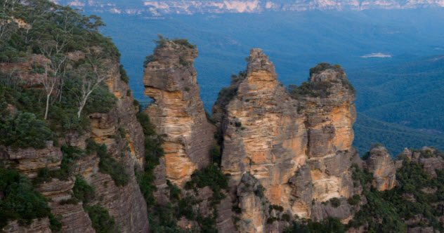
Photo via Wikimedia
In the Blue Mountains of Australia near Katoomba, a tourist town filled with hostels and backpackers, The Three Sisters are a trio of tall sandstone outcroppings formed by land erosion. Given the monikers of Meehni, Wimlah, and Gunnedoo, they have earned a fascinating place in the ancient mythos of the aboriginal peoples of the area.
The legend of the three sisters states that three women of the names above fell into forbidden love with three men from a neighboring tribe. After the three men, who were brothers, absconded with their flames, war ensued and the three women were turned into stone by a shaman to protect them from harm.[1]
The shaman died in the battle that followed, and no one lived who could turn them back. Hence, they remain as oft-photographed pillars of stone, weathering away day by day.
9 Fairy Chimneys
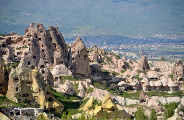
Photo credit: forgottothink.com
The “Fairy Chimneys” of Turkey’s Cappadocia region are a testament to both the power of volcanism and the ingenuity of man. These mesmerizing conical rock formations took shape millions of years ago when volcanic eruptions spewed ash over a vast tract of present-day Turkey and solidified over time into a soft rock known as “tuff.”
Later, the tuff was covered in an additional layer of harder basalt. As erosion took its toll over the ages and epochs, the softer tuff was worn away while more of the basalt remained, creating numerous hollowed-out structures filled with caves.[2]
As humans came to Cappadocia, they found a landscape that, though rugged, was filled with a bounty of premade, ready-to-fill rock houses. And fill them they did.
Throughout recorded history, the region has been inhabited. Its vast network of caves has provided shelter to its denizens for thousands of years through numerous wars fought by the Persians, Greeks, Turks, and so on. The caves are perhaps best known as a refuge for persecuted Christians when their faith was outlawed during the years of the Roman Empire.
8 Mount Roraima
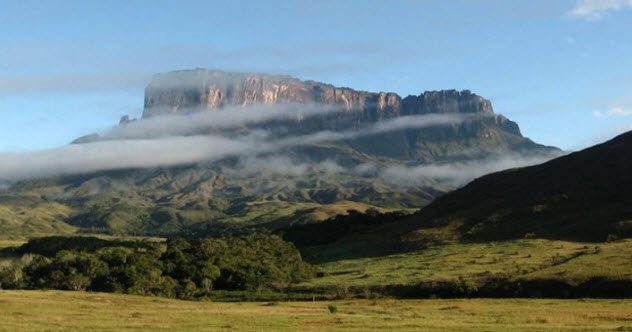
Photo credit: krishmuk91.blogspot.com
Sitting in the heart of Venezuela’s Pakaraima mountain range is Mount Roraima. This formation has more in common with a giant table than it does with the shape of a conventional mountain.
Roraima lies on the Guiana Shield, a Precambrian formation that contains some of the oldest rocks on Earth. Many exceed two billion years in age. Though it was not discovered by the Europeans until 1595 in an expedition led by Englishman Sir Walter Raleigh, one of many intrepid explorers in search of the mythical El Dorado, the giant plateau has held spiritual significance for the Pemon and Kapon natives for time immemorial.
They see Mount Roraima as the stump of a once-mighty tree that bore all the fruits and vegetables that the world had to offer. According to legend, the tree was felled by Makunaima, an evil trickster, who set a flood upon the surrounding lands in its wake.
Today, Mount Roraima bears no fruits, but its unique geology and sheer cliff faces are a tremendous draw for scientists and thrill-seeking climbers alike. The mountain also lies beneath what seems to be a nearly perpetual torrent of rainfall, so Makunaima’s legacy may yet live.[3]
7 Shilin Forest
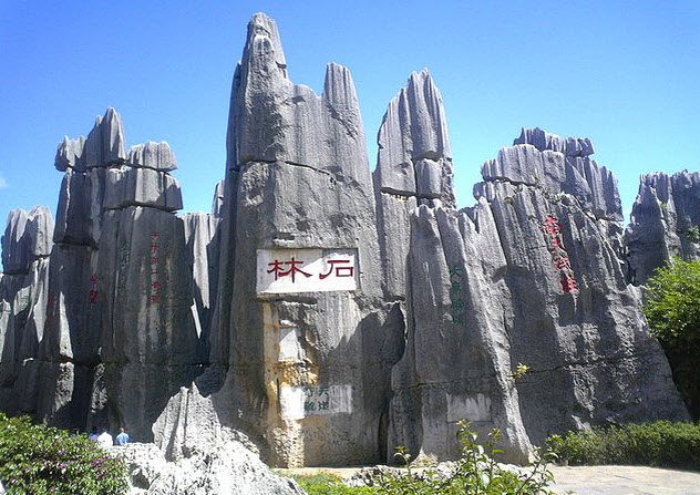
Photo credit: Chenyun
Deep in the heart of China’s southerly Yunnan Province lies a curious formation that one could perhaps mistake for petrified trees from afar. Given the name “Shilin,” or “Stone Forest,” this 500-square-kilometer (193 mi2) collection of stalagmites was formed by limestone erosion and is estimated to be nearly 300 million years old.
It is part of a greater region known as the South China Karst, an area noted for its natural beauty and biodiversity. Though it was only recently deemed majestic enough to achieve status as a UNESCO World Heritage Site, Shilin has held the hearts and minds of those living nearby for millennia and spawned legends of its own.
The most prominent myth circling the forest is the tale of Ashima, a beautiful young girl who was turned into stone as punishment for falling into a forbidden love.[4]
6 Tsingy de Bemaraha
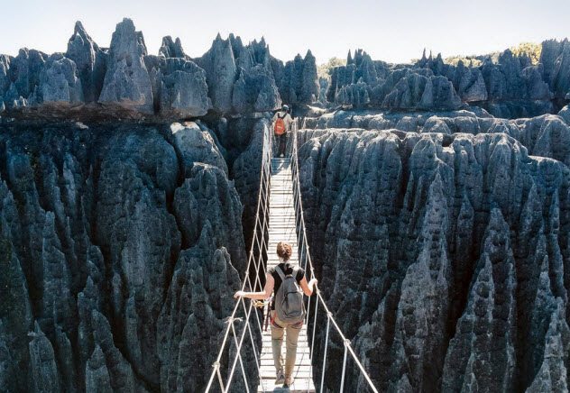
Photo credit: coolhunting.com
Located in the northwest of Madagascar, the world’s fourth-largest island off the coast of Africa, Tsingy de Bemaraha is a colossal mass of jagged limestone outcroppings that puts Shilin to shame. The Tsingys, as they are known, are karstic limestone plateaus that have been dissected and eroded by upwellings of groundwater over millions of years.
Dubbed “The Badlands of Madagascar,” the formation’s name is Malagasy (the native language of Madagascar, which is related to Indonesian) for “where one cannot walk barefoot.” One would imagine that a forest of stone needles, large and small, would certainly be nigh impossible to traverse without a good set of hiking boots.
Despite this, Tsingy de Bemaraha National Park is home to a plethora of endemic species, from lemurs to mangroves to birds of paradise.[5]
5 Son Doong Cave
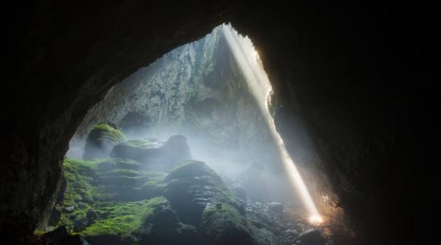
Photo credit: news.com.au
When one thinks of weather systems and climate zones, it’s quite unlikely that caves come to mind. However, in north-central Vietnam, there exists a cave so massive that it constitutes a climate zone all its own.
Discovered by a logger-turned-conservationist named Ho Khanh in 1991, Son Doong Cave, the largest known cave on Earth, is so unbelievably massive that it has its own microclimate. Clouds form and rain falls on a regular basis in this behemoth of a grotto, giving needed moisture to the jungle and river that lie at its floor.
With a length of approximately 9,000 meters (30,000 ft) and a maximum depth of 150 meters (490 ft), Son Doong could easily fit several skyscrapers spanning tens of stories within its confines.
Due to the difficulty of entry into the cave and the dangers associated with it, a very tightly limited number of permits is allotted each year for spelunkers, climbers, campers, and the like to access the cave. Plans are currently underway for the construction of a cable car to increase the ease of access to this geological gem.[6]
4 The Driftless Area
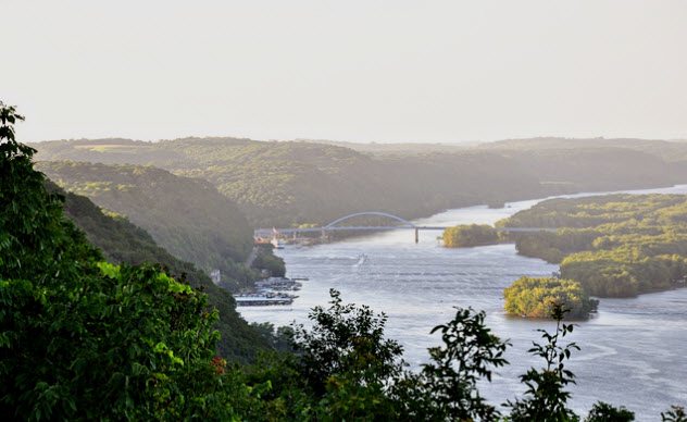
Photo credit: visitiowa.org
The driftless area, also called the Paleozoic plateau region, is an area of land spanning over 42,000 square kilometers (16,200 mi2) in the Upper Midwest of the United States. It covers parts of Illinois, Iowa, Minnesota, and Wisconsin.
Noted for its breathtaking bluffs alongside the Mississippi River and its rugged, deeply dissected valleys, this area is quite arguably the most geologically anomalous region of the United States. As the glaciers of the last ice age moved south, they scoured everything around the area. Almost.
They missed the rocky swath due to the elevation of the Wisconsin highlands, which routed the vast sheets of ice to the east and west of them. The area is something of a time capsule, filled with relics from the ice age such as the monkshood plant and Pleistocene snail.
Another fascinating feature unique to this underrated region is the algific talus slopes, a formation of porous rock filled with ice that remains cold to the touch even in the height of summer. Beneath the slopes lie networks of caves, many of which are also filled with ice.
Between the vistas, the flora, the fauna, and the geology, the driftless area is truly an under-the-radar diamond in the rough.[7]
3 Mount Thor
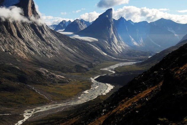
Photo credit: izismile.com
Though there are many mountains that stand much taller than Mount Thor, there is one metric by which this Arctic mount, named for the Norse god of thunder, has them all beat: pure verticality. Located in the Baffin Mountains on Canada’s Baffin Island, this 1,675-meter-tall (5,495 ft) granite massif features the world’s highest vertical drop—an incredible 1,250 meters (4,101 ft).
That’s one and a half times the height of the Burj Khalifa, the world’s tallest building! Mount Thor owes its sheerness to the intense glaciation that scoured the Canadian Arctic during the last ice age. In modern times, the peak is a huge draw for wingsuiters, base jumpers, and hang gliders.[8]
2 McMurdo Dry Valleys
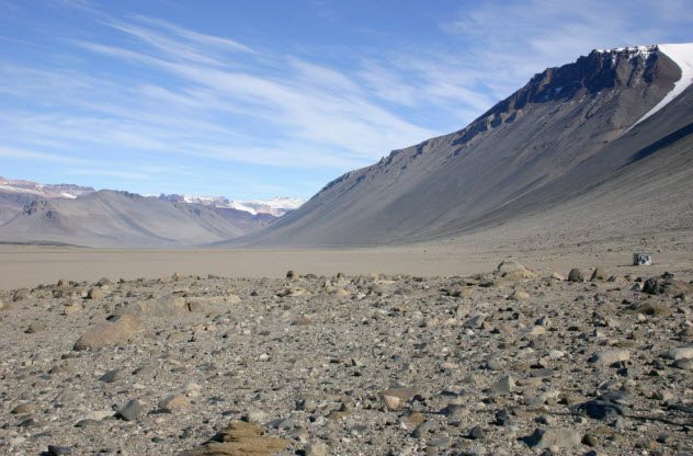
Photo credit: David Saul
Unless you plan on becoming a scientist—and an intrepid one at that—the odds are good that you’ll never find yourself near the McMurdo Dry Valleys. This igneous formation composed of gneiss and granite sits in the Victoria Land region of Antarctica, to the west of McMurdo Sound.
Whereas most of the world’s southernmost continent sits beneath at least 1.6 kilometers (1 mi) of ice, the McMurdo Dry Valleys have managed to remain dry (and not just ice-free). It’s estimated that they haven’t seen precipitation in millions of years, effectively making them the world’s driest desert![9]
Two factors play into the extreme aridity of this basin. First, the mountains surrounding it are high enough that they block coastal precipitation and advancing ice sheets. Additionally, the mighty katabatic winds, which have been known to batter the Antarctic coast at speeds of up to 320 kilometers per hour (200 mph), heat the air and strip it of moisture as they advance inward.
The end result is a barren moonscape where one might expect to find Matt Damon listening to disco classics, waiting to be rescued for the umpteenth time.
1 Siberian Traps
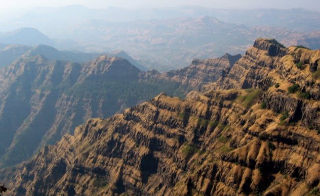
Photo credit: phoenixsic.wordpress.com
Of all the items on this list, the Siberian Traps have far and away the darkest history. They are a massive expanse of cooled and hardened flood basalt covering an area of nearly 2.6 square kilometers (1 million mi2) in the northern reaches of Asiatic Russia.[10]
Their formation is attributed to the largest volcanic eruption in the 4.6-billion-year history of the Earth, a mantle plume which occurred roughly a quarter of a billion years ago. The eruption and its impact on the environment and atmosphere are given credit for the Permian-Triassic extinction event (aka the Great Dying), during which more than 90 percent of all life on Earth ceased to be.
To gaze upon the soaring columns of the traps is to behold the greatest killer that ever was. Today, the traps are renowned for both their breathtaking views and their tremendous reserves of copper, nickel, and palladium.
These reserves have given rise to the Norilsk Nickel company, the world’s largest producer of nickel and palladium. Fitting that the fruits of such a colossal cataclysm would be reaped by man.
Trevor Graydon is just your run-of-the-mill grad school dropout trying to make sense of the post-academic world.
Read more about the weird and wonderful oddities on our planet on 10 Intriguing Stories About Real-Life Water Oddities and 10 Weird And Wonderful Oddities Of Nature.
More Great Lists
 10 Strange Societies You've Probably Never Heard Of
 10 Amazing Castles In Europe You've Probably Never Heard Of
 8 Eerie Urban Legends You've Probably Never Heard Of
 10 People You've Never Heard Of Who Changed The World
 10 Religions In The Middle East You Have Never Heard Of
 10 Amazing Women You've Never Heard Of
 10 UFO Encounters That You've Never Heard About
 10 Best Radio Hoaxes You've Never Heard Before
 10 Creepy Ghost Animals You've Never Heard Of
fact checked by
Jamie Frater
More Great Lists