 Weird Stuff
Weird Stuff
Weird Stuff  Animals
 10 Inspiring Tales of Horses Being Human
 Mysteries
 Top 10 Haunting Facts About the Ghost Ship MV Alta
 History
 10 Surprising Stories About the Texas Rangers
 Humans
 10 Philosophers Who Were Driven Mad by Their Own Theories
 Miscellaneous
 10 Video-Game-Worthy Weapons and Armors from History
 Weird Stuff
 10 Psychics Who Accurately Predicted Wartime Events
 The Arts
 10 Pieces of Art Inspired by a Broken Heart
 Health
 10 Science Fiction-Sounding New Medical Treatments
 History
 10 Surprising Facts About the Father of Submarine Warfare
Weird Stuff 10 Times Real Laws Were Based on Bizarre Hypotheticals
Animals 10 Inspiring Tales of Horses Being Human
Mysteries Top 10 Haunting Facts About the Ghost Ship MV Alta
Who's Behind Listverse?

Jamie Frater
Head Editor
Jamie founded Listverse due to an insatiable desire to share fascinating, obscure, and bizarre facts. He has been a guest speaker on numerous national radio and television stations and is a five time published author.
More About Us
History 10 Surprising Stories About the Texas Rangers
Humans 10 Philosophers Who Were Driven Mad by Their Own Theories
Miscellaneous 10 Video-Game-Worthy Weapons and Armors from History
Weird Stuff 10 Psychics Who Accurately Predicted Wartime Events
The Arts 10 Pieces of Art Inspired by a Broken Heart
Health 10 Science Fiction-Sounding New Medical Treatments
History 10 Surprising Facts About the Father of Submarine Warfare
10 Natural Wonders in the World You May Not Know
We love the natural wonders of this world. We should all know the Grand Canyon, Niagara Falls, and the Great Barrier Reef. However, these are not the only natural beauties that the world has to offer. There are many more.
Some of the natural wonders of the world don’t appear on postcards and in the news, but they are just as incredible as the ones we all know. In some cases, these natural wonders are more breathtaking than the popular ones. These are ten natural wonders in the world you may not know:
Related: Top 10 Attractions To Visit For A Weird Tour Of Europe
10 Chocolate Hills: The Philippines
The Geologic Oddity in the Philippines; The Chocolate Hills
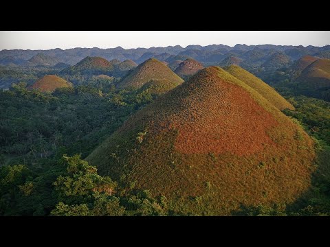
While these sound like something out of a movie, the Chocolate Hills are actually a geological formation in the Bohol Province of the Philippines. The Chocolate Hills are unique because of their “chocolate” color during the dry season. In this location, there are 1,260 hills closely packed together, and as many as 1,776 hills spread over an area of about 19 square miles (50 square kilometers). During the rainy season, the hills are covered in green grass, but as soon as the rain stops, the grass dies. When the grass dies, the color transforms into a chocolaty hue.
The hills vary in height, with the tallest one reaching up to 394 feet (120 meters). Their formation is still a subject of geological debate, but they are believed to be the result of weathering and erosion of marine limestone over millions of years. The Chocolate Hills are featured in the provincial flag of the Bohol Province of The Philippines as a symbol of the abundance of natural attractions in the province. The hills have been developed into a tourist resort, but tourists are not allowed to climb them. You can, however, observe the hills from an observation platform that has 214 steps.[1]
9 Zhangjiajie National Park: China
The Most Beautiful Place in China: Avatar Mountains Of Zhangjiajie (China Vlog 张家界)
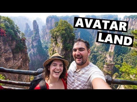
The Zhangjiajie National Park is a national forest park located in Zhangjiajie, Hunan Province of China. It is a mesmerizing world of towering sandstone pillars and awe-inspiring landscapes that look like something from a science-fiction movie. There are also deep ravines, deep canyons, and unusual peaks at the location. The pillar-rock formations throughout the park are its most popular features and what the park is renowned for around the world. Some of these pillar-rock formations rise up to 1,970 feet (600 meters). Zhangjiajie National Park is a UNESCO World Heritage Site and also inspired the floating mountains in James Camron’s Avatar.
There are three ways you can explore the site as a tourist: You can either traverse the park’s extensive network of trails or use the Bailong Elevator—the tallest outdoor elevator in the world. Finally, you can take a stroll on the Zhangjiajie Grand Canyon Glass Bridge, which was the longest and tallest glass-bottomed bridge when it opened to the public in 2016. We need to warn you that the Glass Bridge is not for the faint-hearted. Many tourists who attempted to take a walk on it ran right back in fright after taking just a few steps.[2]
8 Salar De Uyuni: Bolivia
Salar de Uyuni: The World’s BIGGEST Mirror

Bolivia’s Salar De Uyuni is regarded as one of the most extreme and remarkable natural vistas in the world. It is the largest continuous high-salt desert in the world, with an area of 4,085 square miles (10,582 square kilometers). This area is ordinarily breathtaking and amazing, but it is much more beautiful after it rains, as the rainfall transforms it into a giant mirror that reflects the sky above it—creating an optical illusion that you are walking in the clouds.
The Salar De Uyuni is a photographic attraction. This is an unforgettable location for people who love nature. Salar De Uyuni is home to the world’s first salt hotel—a hotel built of salt blocks. It is located at the edge of Salar De Uyuni and is known as “Palacio De Sal,” which means “Palace of Salt.” The Palace of Salt was built to serve tourists who come from great distances to visit the Salar De Uyuni. Salt is the most abundant resource in the area, hence the reason it was turned into a construction material. [3]
7 Pamukkale Pools: Turkey
PAMUKKALE, TURKEY | Everything you need to know about Pamukkale
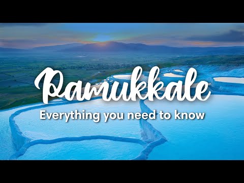
Pamukkale is a natural site in Denizli Province in southwestern Turkey. The name means “Cotton Castle” in the English language, and it is located in Turkey’s Inner Aegean region in the River Menderes valley. Pamukkale is an interesting scene with white travertine terraces and natural hot springs. This creates a breathtaking site because of how the natural hot springs are arranged.
As a tourist, you can enjoy bathing in the pool. To reach the pools, you will have to walk barefoot all the way from the bottom entrance of the site to the top, where the small natural hot springs are located. One of the reasons Pamukkale is also an interesting place to visit is that it is close to the ruins of Hierapolis.[4]
6 The Wave: United States of America
Hiking the Wave in Arizona – Coyote Buttes North – What to expect and what to see
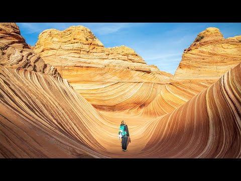
The Wave is a sandstone rock formation in Arizona, USA, close to the Arizona-Utah border. The formation is popular among hikers and photographers for its stunning, colorful, and undulating forms and also for the difficult hike to reach it. Access to “The Wave” is limited due to its delicate nature.
With the large number of people willing to visit it, there is a daily lottery system that is used to select up to 16 people or four groups of people to visit it at a time. Permits for each day are available four months in advance of a planned trip. The best time of the year to visit “The Wave” is during the spring or fall, as the weather is neither too hot nor too cold. The best photographs can be captured during the day when there are no shadows to be seen or in the early evening when stark shadows over the land provide dramatic visuals.[5]
9 Jiuzhaigou Valley: China
Is Jiuzhaigou still beautiful? | China’s most beautiful place reopens after earthquake

The Jiuzhaigou Valley is a nature reserve and natural park located in Sichuan Province in southwestern China. It was designated as a UNESCO World Heritage site in 1992 and a World Biosphere Reserve in 1997. It stretches over 177,915 acres (72,000 hectares) and is known for its many multi-level waterfalls, colorful lakes, and snow-capped peaks.
Jiuzhaigou preserves a series of important forest ecosystems that provide vital habitats for several threatened species of plants and animals. Jiuzhaigou Valley is renowned for its stunning landscape and the way it integrates all the elements of nature—lakes, waterfalls, and limestone terraces, with their clear and mineral-rich waters set in the spectacular alpine mountains.[6]
4 Iguazu Falls: Argentina/Brazil Border
THE BIGGEST WATERFALLS IN THE WORLD | Iguazu Falls, Brazil (275 waterfalls!)

Iguazu Falls are waterfalls of the Iguazu River on the border of the Argentine province of Misiones and the Brazilian State of Paraná. Together, they make up the most extensive waterfall system in the world. The falls divide the river into the upper and lower Iguazu. The falls are surrounded by lush rainforests that echo the thundering sounds of crashing water.
Iguazu Falls is made up of more than 275 waterfalls and cascades, which makes it a very spectacular sight to behold. Iguazu Falls is on this list because of its relative obscurity. Despite besting Niagara Falls in almost every way you may consider the two, Niagara Falls is far more popular because the Argentina/Brazil border is not a popular destination with tourists.[7]
3 Tsingy De Bemaraha: Madagascar
Madagascar, Tsingy de Bemaraha National Park
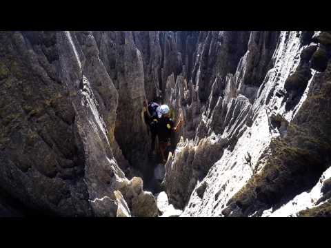
Tsingy De Bemaraha is made of karstic plateaus where groundwater has undercut the elevated uplands and gouged caverns and fissures into the limestone, giving the rock formation a unique look. The word “Tsingy” is indigenous to the Malagasy language; it means “where one cannot walk barefoot.” Tsingy De Bemaraha is a challenging and rewarding destination for adventurers who may wish to explore it.
The park is only accessible via wooden walkways and rope bridges dangling over vertical chasms below. The site contains communities of rare and threatened animal species. The Tsingy De Bemaraha is located in the District of Antsalova and in the region of the central west part of Madagascar. The unique features of the site make it widely considered a center for endemism because of its wealth of faunal and floral species.[8]
2 Mount Roraima: Brazil, Guyana, and Venezuela
Mount Roraima in South America – A Seven Day Hike to a Natural Wonder
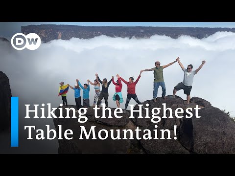
Mount Roraima is located at the junction of Brazil, Guyana, and Venezuela. Mount Roraima is a geological marvel due to its characteristic large, flat surface. The highest point of Mount Roraima is located on the southern edge of the cliff at an altitude of 9,219 feet (2,810 meters) in Venezuela. But there is another protrusion at an altitude of 9,094 feet (2,772) meters at the junction of the three countries in the north of the plateau in Guyana.
Many of the species found on Mount Roraima are unique to the plateau. On the mountain grow various types of forests with a wide variety of orchids, bromeliads, and carnivorous plant species. Almost all the tourists that go to the mountain approach it from the Venezuelan side.[9]
1 Lake Hillier: Australia
Can you SURVIVE in this PINK lake in Australia?
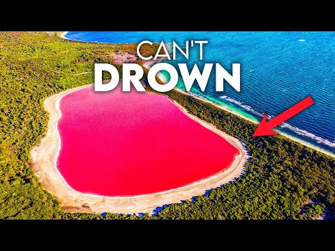
Lake Hillier is a saline lake on the edge of Middle Island, noted for its pink color. In case you do not know, the colors formed naturally and were not influenced by any man-made actions. Lake Hillier is about 1,970 feet (600 meters) in length and about 820 feet (250 meters) in width. The lake is surrounded by a rim of sand and a dense woodland of paperbark and eucalyptus trees, with a narrow strip of sand dunes covered by vegetation separating its northern edge from the north coast of Middle Island.
The lake was first discovered in 1802 by navigator and cartographer Matthew Flinders, who took samples from the lake and mentioned its existence in his journal. For some time, the lake was used as a salt mine, but now, the lake is used for tourism purposes exclusively. Lake Hillier’s pink waters have made it an Instagram-worthy destination, attracting curious travelers from around the world. Swimming in the lake is prohibited, but visitors can take a helicopter ride across the length and breadth of the lake.[10]
More Great Lists
 10 Planet-Saving Inventions That You May Not Know Much About
 10 Things You May Not Know About Mythical Creatures
 10 Strange Facts of Louis XIV That You May Not Know
 10 Fascinating Things You May Not Know About the Mothman
 10 Things You May Not Know about the Titanic Disaster
 10 Things You May Not Know about the Production of…
 10 Things You May Not Know about Crows
 Top 10 Must-Visit Natural Wonders
 Ten Beautiful Natural Wonders That No Longer Exist
fact checked by
Darci Heikkinen
More Great Lists