 Our World
Our World
Our World  Religion
 10 Forgotten Greek Gods Beyond Olympus
 Crime
Crime 10 Infamous Crime Scenes That Became Tourist Hotspots
 Our World
 10 Rare Hybrids with Wild Backstories
 Space
Space 10 Amazing Explanations for Cosmic Conundrums
 Movies and TV
 10 Film Productions That Went Too Far
 Weird Stuff
 10 Historical Facts That Ruin Your Timeline
 History
 10 Maritime Folktales with a Real-Life Twist
 Crime
Crime 10 Notorious Prison Gangs That Became Criminal Empires
 Music
Music Top 10 Hit Song Lyrics That Became Cultural Catchphrases
Our World 10 Terrifying Forces Scientists Recreated in the Lab
Religion 10 Forgotten Greek Gods Beyond Olympus
Crime 10 Infamous Crime Scenes That Became Tourist Hotspots
Who's Behind Listverse?

Jamie Frater
Head Editor
Jamie founded Listverse due to an insatiable desire to share fascinating, obscure, and bizarre facts. He has been a guest speaker on numerous national radio and television stations and is a five time published author.
More About Us
Our World 10 Rare Hybrids with Wild Backstories
Space 10 Amazing Explanations for Cosmic Conundrums
Movies and TV 10 Film Productions That Went Too Far
Weird Stuff 10 Historical Facts That Ruin Your Timeline
History 10 Maritime Folktales with a Real-Life Twist
Crime 10 Notorious Prison Gangs That Became Criminal Empires
Music Top 10 Hit Song Lyrics That Became Cultural Catchphrases
Ten Tragic Tales From NYC’s Small Islands
New York City is home to perhaps the most famous island in the world: the 13-mile long, 2-mile wide parcel called Manhattan. In fact, of NYC’s five boroughs only one – The Bronx – is connected to the mainland US.
Far smaller tracts dot the East River, Long Island Sound and other bodies of water flowing through the city limits. Most of them have harrowing histories.
10 A Pox on Thee: Roosevelt Island’s Ruins
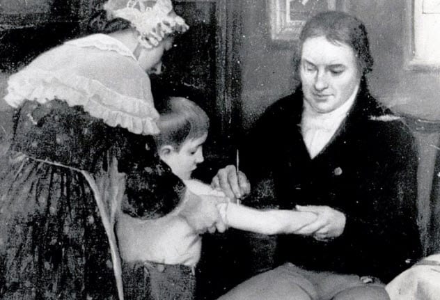
Few diseases have been more impactful than smallpox. Notable victims include France’s King Louis XV, who it killed, and England’s Queen Elizabeth I, who wore makeup to conceal cringeworthy facial scarring from battling the disease as a child. In America, an estimated 90% of Native Americans died from smallpox, which they contracted from white settlers – including instances of intentional transmission through tainted blankets, a sort of rudimentary biowarfare.
Smallpox was finally eradicated in 1979 – but not before it had its way with New York.
Roosevelt Island is a narrow, two-mile-long strip between Manhattan and Queens, large enough for its own subway stop, its trademark tram of Spider-Man fame, a few apartment buildings and a technical campus for Cornell University. Its southern tip contains two adjacent, starkly different structures: a pristine park and monument dedicated to its namesake, Franklin Delano Roosevelt, and the ruins of a 19th Century hospital where smallpox victims were segregated from the city and cared for, often futilely.
From 1856 until 1875, the facility known today as Renwick Hospital (after its architect) treated roughly 7,000 patients a year. Nearly 10,000 victims perished there over a span of two decades. Then, as with many institutions, the city’s swelling population caught up with it. As Roosevelt Island’s residence grew, the smallpox unit was shifted to tinier, more remote North Brothers Island. By the 1950s, Renwick Hospital had become useless and was abandoned by the city, quickly falling into disrepair.
9 Randall’s/Ward’s Islands: Fun Present, Dysfunctional Past
Exploring Randall’s Island and Walking to Manhattan and The Bronx in NYC

A mile north of Roosevelt Island is Randall’s Island, a shorter yet wider patch at the confluence of Manhattan, Queens and The Bronx accessible by the Robert F. Kennedy (formerly the Triborough) Bridge. Today, Randall’s is best known for two things: concert venues hosting popular music festivals, and soccer pitches, baseball diamonds and football fields where many of NYC’s schools hold practices and games. (Fun tourism fact: It also has the city’s best mini-golf course.)
The area wasn’t always such a good time. For decades, it was where the city tucked away many of its poor, sick and institutionalized. As with many of this list’s other tiny tracts, NYC officials saw the river as a ready-made moat to physically ostracize misfits; actually, “Island of Undesirables” was once Randall’s Island’s nickname.
Or rather, its neighbor’s. Because Randall’s Island itself was segregated – by a manmade stream aptly called Little Hell Gate Channel. They named the secondary turf Ward’s Island, which, though less than a square mile, nonetheless made room for the terminally ill, criminally insane and juvenilely delinquent. Other lowlights included a disreputable orphanage and a potter’s field. A literal shithole, Ward’s also housed (and continues to house) a sewage treatment plant.
Randall’s and Ward’s were reconnected in the 1960s, and the duo’s depressing past isn’t completely behind them. The former site of a decrepit insane asylum is now the barely-less-decrepit Manhattan Psychiatric Center.
8 Made for Quarantining: Hoffman & Swinburne Islands
Staten Island’s Mysterious Island: Hoffman Island explored

Despite the famous statue that, starting in 1876, would adorn another nearby island – one that urged foreign lands to “give me your tired, your poor, your huddled masses yearning to breathe free” – one thing New York City didn’t want was your contagiously ill.
Just south of the Verrazzano Narrows Bridge, which connects Brooklyn and Staten Island, are two tiny tracts that have existed for exactly 151 and 148 years, respectively. The smaller, Swinburne, was created from landfill in 1870, with its larger counterpart, Hoffmann, completed in 1873. At the time, however, few knew these fanciful names; to most, they were simply Lower and Upper Quarantine Islands.
NYC’s most famous immigration intake facility, Ellis Island, did not commence operations until 1892. In the 35 years prior, new arrivals were processed at Castle Garden (now Castle Clinton) at Manhattan’s southern tip.
Before 1870, immigrants suspected of contagion were quarantined in Staten Island – not exactly fair, since it didn’t become part of NYC until 1898. So NYC used landfill to create two islands – a large one for those potentially exposed (yet asymptomatic), and small one for those showing symptoms of one infectious disease or another. So basically a tiny, man-made petri dish.
Surprisingly, only about a dozen people died there, including a doctor. Notably, during World War I Swinburne’s hospital was used to treat US soldiers suffering from venereal disease. Today, both are uninhabited bird sanctuaries, their ruins incorporated into Gateway National Recreation Area.
7 What’s in a Name? Rat Island
Why This Guy Paid $176K for Rat Island, New York’s Smallest Piece of Land | New York Post

A half-mile off The Bronx’s causeway-connected City Island, in Long Island Sound, is a 2½-acre islet with no definitive origin surrounding its less-than-appealing name: Rat Island. Three distinct possibilities exist.
Let’s start with the most mundane, which involves marine navigation. Since the island lies between two larger parcels of land – City Island and Hart Island (for more on Hart Island, see the final two entries) – it’s likely rattles were once used as noisemakers to warn night-sailing ships of nearby ground. In this theory – espoused by the island’s current owner, Alex Schibli – Rat is short for “rattle.”
Now the more entertaining ones. During the typhoid fever scares of the 1800s, the island housed a 40-person quarantine hospital. Back then, the islet was considered part of Pelham, and became known alliteratively as the Pelham Pesthouse. All this activity, of course, attracted vermin – hence, Rat Island.
But the last possibility is the coolest. Among other notorious institutions, nearby Hart Island once contained a prison. In the 19th Century, “rat” was a term used by guards to describe inmates. To escape to City Island (and the mainland) was a mile swim, and the tiny islet in between was a natural resting point; many even wore boxes on their heads to be mistaken for floating trash. Rat Island: a respite en route to felon freedom.
6 Smallest & Oddest: U Thant Island
A Secret New York Island That You Can Never Visit

On August 28, 1973, subway riders lived every New Yorker’s nightmare. A concrete slab in a tunnel under the East River fell, killing one passenger and trapping 1,000 others in 115-degree heat and smoke for over an hour. Their near-tomb was Steinway Tunnel – named for the pianos made in Astoria, Queens.
The tunnel had always been troubling. Around 1880, William Steinway wanted to run trains between Manhattan and his promising piano factory in Queens. The project got off the ground, underground, then… boom! An explosion killed five workers and bankrupted the contractor.
Still, the tunnel endured, and its dregs created a 200×100-foot islet off the East Midtown coast. It was named Belmont island, after the project’s financer.
Unknown to all, the tiny tract would later grace the sightline of the United Nations headquarters, completed in 1948. Now, a man-made mound of dirt became the perfect guerrilla protest destination. In 1972, Belmont was declared “Soviet Jewry Freedom Island” and occupied for 2½ hours to protest Soviet emigration policy.
But it was five years later that Belmont became NYC’s oddest-named island… unofficially, anyway. In 1977, followers of the guru Sri Chinmoy, who served as the UN’s interfaith chaplain, leased the land and renamed it after the Burmese former United Nations Secretary General U Thant, a friend of Chinmoy. Today, it’s home to a “oneness arch” of Thant’s personal items.
5 Fake Island, Real Damage: The Black Tom Explosion
The 1916 Black Tom Explosion

The year was 1916 and, though the U.S. had yet to enter World War 1, the country’s manufacturing heft made it a steady supplier of munitions to the English and French. The majority of these were shipped from greater New York City – actually just across the river in Jersey City, New Jersey.
The embarkation point was a man-made island – Black Tom Island, allegedly named for a local dark-skinned fisherman (woke much, 1910s?) – originally built around a tough-to-spot rock that made navigation dangerous. There, a railroad hub had been built where, on July 30, 1916, some two million tons of war materials were ready for shipment overseas.
Then… boom! German saboteurs blew it up. The explosion was the equivalent of an earthquake measuring between 5.0 and 5.5 on the Richter Scale. Windows within a 25-mile radius shattered, the outside wall of Jersey City’s City Hall was cracked, and metal shrapnel damaged the Statue of Liberty’s skirt. New arrivals on nearby Ellis Island were evacuated. Seven people were killed, and an estimated $20 million in damages incurred.
Combined with continued German submarine attacks and its attempts to convince Mexico to ally itself with the Kaiser against America, the Black Tom incident was a factor in America’s eventual entrance into the war in April 1917. Today, Black Tom Island is connected to Liberty State Park, which gained notoriety as a massive triage location in the immediate aftermath of the September 11, 2001 terrorist attacks.
4 Just Offal: NYC’s Smelliest Island
Barren Island: The Other Side Of Dead Horse Bay/Glass Bottle Beach Metal Detecting #metaldetecting

Before NYC was a subway and taxi town it was, like many cities, a horse town. Horse-drawn carriages permeated the streets; by 1900, some 200,000 horses lived in NYC – and are, in fact, a big reason many residences have staircases leading up to the front door. Who wants their first step outside to be ankle-deep in horseshit?
Anyway, those horses inevitably died and, when they did, their carcasses were used to make glue and fertilizer. Between 1850 and 1930, much of this occurred on a small strip off Brooklyn’s southeast shore called Barren Island. Over decades, the offal of hundreds of thousands of horses quite literally bled into the surrounding waters, lending a name – Dead Horse Bay – that exists to this day.
Here, the story of Barren Island goes from just plain gross to just plain weird. Around 1900, the tract also became used as a trash heap. Filled to capacity by 1930, it was capped and left to rot, which much of it invariably did.
But then, in 1950, the cap burst. Ever since, slower-degrading trash – such as glass – has been steadily leaking up to the island’s surface, as well as into the bay. Dead Horse Bay suddenly had an equally discomfiting neighbor: Glass Bottle Beach.
For years, the area became a popular destination for antique enthusiasts searching for today’s treasure amid yesterday’s rubbish. However, access to the area was suspended last year when high levels of radioactivity were detected.
3 Among America’s Worst: Riker’s Island
Violence Inside Rikers

The island synonymous with incarceration in New York City wasn’t always a hellhole consistently ranked among the ten worst places to serve time in the United States. In fact, it was once quite quaint.
Riker’s is named for Abraham Rycken, a Dutch settler who moved to Long Island in 1638 and purchased it in 1664. Rycken’s descendants, the Ricker family, owned the tract until 1884, when it was sold to the city for $180,000. Along with attractive farmland, the island served as a training ground for New York troops during the Civil War.
Its downturn started in 1925. Now officially part of greater New York City, municipal leaders wanted to replace the crowded, dilapidated prison on the aforementioned Roosevelt Island (then known as Welfare Island). They chose Riker’s, and its prison opened in 1932.
Why Riker’s? Because it was already a disaster area. By 1930, some 1.5 million cubic yards of refuse – more than the amount of debris displaced to build the World Trade Center in the 1960s – had been dumped there. Much of the waste was ash from coal heating and incinerators, causing spontaneous phosphorescent fires. Fun.
Today, Riker’s Island contains ten city jails of varying decay and danger. Until last year, many detainees were poor folks arrested for minor offences, unable to afford bail and awaiting a hearing at the city’s notoriously backlogged courts.
2 A Mile Long, a Million Dead: Hart Island
Hart Island Erosion Unearths Skeletons

Half a mile east of The Bronx’s more populous City Island, the mile-long, 1/3-mile-wide Hart Island has perhaps the most morbid history of any parcel in greater NYC.
It started promisingly enough. Hart Island was first publicly utilized in 1864, as training grounds for Black Union troops during the Civil War. As POWs mounted that year – primarily because Confederate leaders refused to take Black prisoners, prompting Union leaders to eliminate prisoner exchanges in protest – a war prison camp was added. Following the war, Hart housed other not-so-fun facilities including a tuberculosis sanitarium, a jail, a homeless shelter and a boys’ reformatory.
But most prominently, the island was a potter’s field. Incredibly, the remains of over a million bodies lie in shallow mass graves throughout the diminutive tract. A fancy funeral this was not: burials on Hart included the homeless, indigent, unclaimed, and disease-ridden (more on that shortly).
In fact, burials still occur today, though far fewer – about 1,500 per year. The sad deed is performed by residents of another nearby island: Riker’s Island, the city’s notorious primary jail. So essentially, inmates are ferried to forced gravedigging duties on the creepiest place in the entire city. Don’t ever get arrested in New York, folks.
Recently, an effort was launched to identify as many souls buried at Hart Island as possible. The initiative includes a fascinating interactive map showing the project’s progress.
1 Hart-breaking: Hart Island, COVID & AIDS
In the previous entry we mentioned that the pace of burials at Hart Island had slowed. That was until…oh, about March of 2020.
A hub of international travel, New York City was among the first US locations to be inundated by the COVID-19 pandemic. It wasn’t just hospitals that were overwhelmed: the city’s morgues quickly ran out of room, forcing bodies to be stored in massive freezer trucks and other makeshift settings.
By March 2021, NYC was on pace to bury 1 in 10 COVID victims at Hart. Pictures of workers in protective gear burying people in shallow graves permeated local media. At least 2,300 adults were interred there in 2020 — 2½ times the 2019 figure and 1,000 more than in 1988.
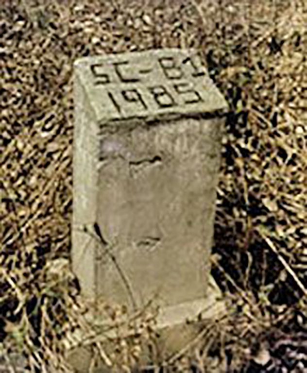
That year – 1988 – is significant because it marked the peak of AIDS-related deaths in NYC. Hart Island is intimately linked with the AIDS epidemic, due largely to the period’s widespread paranoia. Starting in 1985, the first NYC residents identified as AIDS victims were shipped to Hart Island, then buried in an isolated area away from the remains of other individuals, in deep graves under several feet of dirt rather than the typical three.
In fact, the only single marked gravesite on Hart Island belongs to NYC’s first pediatric AIDS victim. The concrete marker simply reads “SC (special child) B1 (Baby 1) 1985.”
10 Strange and Mysterious Islands
More Great Lists
 Ten Unusual Pets Of Famous Writers And Artists
 Top Ten Banned Snacks
 Ten Amazing Slips In Time
 Ten Misconceptions About The Illuminati
 Ten Astonishing New Discoveries About The Cosmos
 Ten Of The Weirdest Elon Musk Moments
 Top 10 Islands With Fascinating Stories And Artifacts
 Top 10 Truly Spectacular Islands For Post-Covid Travel
 10 Shockingly Small But Adorable Aquatic Creatures
fact checked by
Jamie Frater
More Great Lists