 Weird Stuff
Weird Stuff
Weird Stuff  Creepy
 10 American Urban Legends Far Stranger Than Bigfoot
 Movies and TV
 10 Radical Reimaginings of Frankenstein
 Facts
Facts 10 Explosive Facts You Probably Don’t Know About Volcanoes
 Pop Culture
 0 Things That Became Massive Hits the Second Time Around
 Humans
 History’s 10 Little-Remembered Acts of Charity
 The Arts
 10 Iconic Masterpieces Attacked by Pure Pettiness
 History
 History’s Ten Most Lopsided Battles Ever
 Movies and TV
 10 Great Meta Horrors to Watch Before Scream 7
 History
 10 Brave Women Who Fooled Entire Armies
Weird Stuff 10 of the Most Bizarre Buildings Around the World
Creepy 10 American Urban Legends Far Stranger Than Bigfoot
Movies and TV 10 Radical Reimaginings of Frankenstein
Who's Behind Listverse?

Jamie Frater
Head Editor
Jamie founded Listverse due to an insatiable desire to share fascinating, obscure, and bizarre facts. He has been a guest speaker on numerous national radio and television stations and is a five time published author.
More About Us
Facts 10 Explosive Facts You Probably Don’t Know About Volcanoes
Pop Culture 0 Things That Became Massive Hits the Second Time Around
Humans History’s 10 Little-Remembered Acts of Charity
The Arts 10 Iconic Masterpieces Attacked by Pure Pettiness
History History’s Ten Most Lopsided Battles Ever
Movies and TV 10 Great Meta Horrors to Watch Before Scream 7
History 10 Brave Women Who Fooled Entire Armies
10 Perilous Hikes Still Open to the Public Today
These ten trails span the globe, from Asia’s sacred peaks to North America’s desert labyrinths, each offering a unique blend of natural beauty, cultural resonance, and heart-stopping exposure. Whether it’s the vertiginous boardwalks of China, the engineered marvels of Spain, or the secluded canyons of Utah, every hike demands respect for both terrain and tradition.
Related: 10 Best Hiking Trails in America with Breathtaking Views
10 Mount Fuji, Japan
Mount Fuji: How to Climb Japan’s Most Famous Mountain

Climbing Mount Fuji 12,388 feet (3,776 m) each summer is both a cultural pilgrimage and a serious alpine undertaking. Thousands of climbers—from first-timers to seasoned alpinists—tackle trails like Yoshida and Subashiri between July and September. One international student group famously began their ascent at midnight, battling 31 mph (50 km/h) gusts and near-freezing temperatures to catch the Goraikō sunrise, sharing headlamps, medical supplies, and motivation en route. Despite well-maintained trails and mountain huts every few kilometers, risks abound: altitude sickness above 8,202 feet (2,500 m) can strike suddenly, storms appear without warning, and overcrowding fuels “bullet climbs” that leave hikers exhausted and vulnerable.
Local authorities now charge a modest climbing fee, enforce staggered nighttime closures, and strongly recommend at least one overnight stay in a 9,843 feet (3,000 m) hut to acclimatize. Essential gear includes warm layers, a waterproof shell, sturdy boots, and a reliable headlamp (with spare batteries). Climbers should reserve huts early, verify which trails are open, and pace themselves—aiming for “climb high, sleep low” if time allows, or at minimum, incorporating plenty of rest stops to reduce the chance of acute mountain sickness.[1]
9 Cascade Saddle Track, New Zealand
Cascade Saddle Route: Alpine Tramping (Hiking) Series | New Zealand
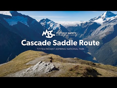
High in Mount Aspiring National Park, the Cascade Saddle Track rises to 3,852 feet (1,174 m), offering sweeping vistas of Mount Aspiring [13,232 feet (4,033 m)] and glacial valleys—but also sudden storms, snowfields, and avalanche-prone couloirs. Two trampers learned this the hard way when a late-spring snowstorm stranded them on the exposed saddle; they survived 36 hours by using their tent fly as shelter before rescue could reach them. Because November weather can feel like midwinter, the Department of Conservation (DOC) urges summer ascents (January–February) while keeping an eye on avalanche advisories and local updates.
Beyond reliable waterproofs and sturdy boots, hikers may need crampons and an ice axe well into late January. Navigation demands topographic maps, compass or GPS proficiency, and backup batteries. Always file an itinerary with DOC rangers, carry 4 L of water per person per day, and consider a personal locator beacon—only experienced trampers with solid alpine skills should attempt this route.[2]
8 Orla Perć (Eagle’s Path), Poland
Orla Perć, Tatra Mountains – WE THINK TOO MUCH AND FEEL TO LITTLE

Orla Perć in the Tatra Mountains is Europe’s most notorious ridge trail, a 14 km scramble above 7,546 feet (2,300 m) with chains, ladders, and 328-foot (100-meter) drops. Since the early 1900s, over a hundred hikers have perished here—among them a solo trekker caught in a thunderstorm at Zawrat Pass, who clung to dripping chains until fellow climbers shared rope and guided him to safety. Such incidents underscore both the route’s raw challenge and the tight-knit community spirit in the Tatras.
Attempt only between late June and mid-September, when snow is minimal, and chains aren’t ice-coated. Helmets, gloves, sturdy boots, and a via ferrata set (harness and lanyard) are non-negotiable. With 10–12 hours required to traverse the full ridge, start well before dawn. Inexperienced hikers should hire a licensed mountain guide, and everyone must monitor rapidly changing forecasts to avoid being caught in storms above the tree line.[3]
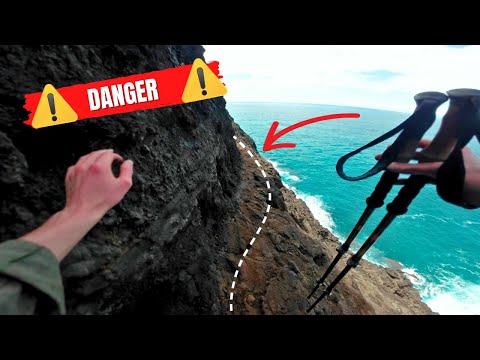
7 Barranco del Infierno, Tenerife, Spain
Exploring Tenerife’s Stunning Barranco del Infierno Hike

“Hell’s Gorge” winds 4 miles (6.5 km) through volcanic cliffs to Tenerife’s highest waterfall [656 feet (200 m)], once closed after a 2009 fatality, and is now regulated with helmets, guide quotas, and digital entry logs. A family from Madrid experienced the transformation: their skeptical teens became spellbound by endemic flora and the rare Tenerife bluet butterfly before cooling off beneath the cascade’s icy mist. Controlled access (300 daily hikers) and online reservations ensure both safety and conservation of this biodiverse ravine.
Trail closures during heavy rain guard against rockfalls, and children under 5 are prohibited (under-18s require adult supervision). Hikers should book well in advance, respect protected species by staying on the path, and carry out all litter. Combined with clear signage and mandatory safety gear, these measures have made Barranco del Infierno a thrilling yet responsibly managed adventure.[4]
6 The Maze, Canyonlands NP, USA
The Maze: Canyonlands National Park, Utah, USA [Amazing Places 4K]
![The Maze: Canyonlands National Park, Utah, USA [Amazing Places 4K]](https://listverse.com/wp-content/plugins/wp-youtube-lyte-main/lyteCache.php?origThumbUrl=https%3A%2F%2Fi.ytimg.com%2Fvi%2FUhNuzZkhQBY%2F0.jpg)
The Maze, one of America’s remotest backcountry regions, tests even veteran canyoneers with unmarked routes, scarce water, and a rugged 4×4 approach that can wash out overnight. One five-day loop attempt turned into a sixth as monsoon-swollen crossings forced improvisation; the group survived by rationing water, camping in an alcove, and finally using a talus slope to regain their trailhead. Their story highlights the Maze’s beauty and brutal isolation—where self-reliance isn’t optional.
Success here hinges on a high-clearance 4×4 (with recovery gear), multiple navigation tools (satellite GPS, USGS maps), and at least 4 quarts (4 L) of water per person per day with robust filtration. Permits—secured months in advance—must be filed with park rangers, along with a detailed itinerary. Only those with extensive desert-canyon experience, route-finding skills, and emergency-ready kits should attempt this labyrinth.[5]
5 Aonach Eagach Ridge, Scotland
The Narrowest Ridge on Mainland Britain – The Aonach Eagach Ridge

The 1.24-mile (2-kilometer) Aonach Eagach Ridge in Glen Coe is Britain’s narrowest mainland crest, demanding exposed scrambling over rock features like Devil’s Staircase, with no easy escape once committed. Two Munro-baggers faced dense September mist halfway along; by roping up, using helmets, and moving in unison hand-over-hand, they navigated to safety near the Glen Coe Cowshed Bothy—demonstrating meticulous planning and teamwork.
Tackle the ridge only in dry conditions; winter ascents require full ice-axe and crampon proficiency. A party of at least two (ideally three) should carry a 20 m rope, slings, quickdraws, and helmets. Always consult Mountain Rescue logs for recent incidents, consider hiring a local guide if uncertain, and inform someone of your plans before departure.[6]
4 Half Dome via the Cables Route, Yosemite NP, USA
Half Dome Cables ALL THE WAY UP
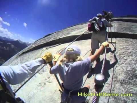
Half Dome’s cables provide a near-vertical finale to a 14–16 mile hike with 4,800 feet (1,463 m) of gain—an ascent many consider the crown jewel of Yosemite. A Pacific Crest Trail thru-hiker famously saved it as his “grand finale,” starting at 3 a.m., gripping rust-proofed steel cables at dawn and summiting in tears of relief and triumph over his acrophobia. Yet the cables have claimed lives from falls and lightning strikes, underscoring the need for respect and preparation.
Permits (via lottery from March–October) limit daily ascents; cables typically open late May through mid-October, weather-dependent. Essential gear includes leather-palm gloves, sturdy boots, and 3 quarts (3 L) of water. Climbers must begin pre-sunrise to avoid afternoon thunderstorms and carry layered clothing for swift temperature changes at higher elevations.[7]
3 Kalalau Trail, Kauai, Hawaii, USA
Hiking the Kalalau Trail – Most DANGEROUS Hike in the World
Kauai’s Kalalau Trail traverses 11 miles (17.7 km) of the Nā Pali Coast, dipping into emerald valleys, beneath towering cliffs, and past hidden waterfalls—yet flash floods and rockslides can turn its beauty terrifying. A family expedition took refuge in a lava-tube shelter when torrential rains transformed Hanakapiai Beach’s creek into a raging torrent. After boiling creek water for hours, they emerged at dawn to a double rainbow arching over the coast, calling it “the beauty after the beast.”
Permits are mandatory beyond mile 2, with camping only at Kalalau Camp to protect fragile ecosystems. Hikers must carry a reliable water filter, a bear-proof food canister (to deter wild pigs), and an ultralight tent sturdy against coastal winds. Checking weather advisories before and during the trek is vital—stream crossings in high water are often deadly, so patience and caution can mean the difference between an epic journey and tragedy.[8]
2 El Caminito del Rey, Málaga, Spain
Caminito del Rey – “the world’s most dangerous walkway”

Once a perilous ruin, El Caminito del Rey was originally carved into the sheer limestone walls between 1901 and 1905 to facilitate dam construction. By the 1990s, crumbling planks earned it the title “world’s most dangerous walkway,” prompting closure in 2000. After a €9 million restoration and five years of engineering work, it reopened in 2015 with reinforced stainless-steel walkways, high-strength guardrails, and even a cantilevered glass-floored viewpoint.
Access remains tightly controlled: only 300 tickets per day, all reserved online weeks in advance. Visitors must don ASTM-approved helmets at the entrance and are accompanied by trained guides at a maximum ratio of 1:12. No one under eight is permitted, and hikers follow a one-way loop that averages 3.5 hours. Opt for autumn or spring weekday mornings for cooler conditions and thinner crowds.[9]
1 Mount Huashan Plank Walk, China
World’s DEADLIEST Hike – CHINA’S Huashan Plank Walk 🇨🇳

Towering over the Wei River valley at 7,087 feet (2,160 m), Mount Huashan’s plank walk is more than a stunt—it’s a centuries-old rite tied to the Taoist pilgrimage. The current safety-harness system, introduced in 2005, retrofitted the planks with rated carabiners and continuous overhead rails, reducing fatal falls from dozens per year to virtually zero. Yet each harness checkpoint still logs your ascent time, ensuring chains aren’t overcrowded.
Beyond the plank, Huashan offers four stone-staircase peaks, each with its own temple and legend. Cable cars reach the North and West summits, catering to less audacious visitors. Essential gear includes grippy hiking shoes, lightweight gloves, and a small daypack—anything bulkier can swing dangerously on the narrow boards.[10]
More Great Lists
 10 Formerly Secret Tunnels That Are Now Open to the Public
 10 Most Dangerous Hikes in the World
 10 Long-Dead Languages Still Affecting Society Today
 Ten Long-Dead People Who Are Still Messing Up Today's World
 10 Accidents to Make You Think Twice About Swimming…
 10 Real-Life Criminals That Are Considered Heroes by…
 10 Documentaries That Changed Public Perception
 10 Weird and Wonderful Public-Access TV Shows
 10 of the Most Disturbingly Haunted Public Houses in the UK
fact checked by
Darci Heikkinen
More Great Lists