 Weird Stuff
Weird Stuff
Weird Stuff  Mysteries
 10 Tragic Disappearances and Deaths in Joshua Tree National Park
 History
 10 Ways Childhood Really Sucked in the Old West
 Music
Music 10 Name Origins of Famous Bands from the 1990s
 Religion
 10 Biggest Turnarounds by the Catholic Church
 Weird Stuff
 10 Unbelievable Times Laws Had Unintended Consequences
 Humans
 Ten Historic Women Who Deserve Way More Credit Than They Got
 Movies and TV
 10 Films That Spawned Major Lawsuits
 History
 Ten Times Towns Were Wiped Off the Face of the Earth
 Creepy
 10 of the Most Disturbingly Haunted Public Houses in the UK
Weird Stuff 10 Niche Subcultures That Are More Popular Than You Might Think
Mysteries 10 Tragic Disappearances and Deaths in Joshua Tree National Park
History 10 Ways Childhood Really Sucked in the Old West
Who's Behind Listverse?

Jamie Frater
Head Editor
Jamie founded Listverse due to an insatiable desire to share fascinating, obscure, and bizarre facts. He has been a guest speaker on numerous national radio and television stations and is a five time published author.
More About Us
Music 10 Name Origins of Famous Bands from the 1990s
Religion 10 Biggest Turnarounds by the Catholic Church
Weird Stuff 10 Unbelievable Times Laws Had Unintended Consequences
Humans Ten Historic Women Who Deserve Way More Credit Than They Got
Movies and TV 10 Films That Spawned Major Lawsuits
History Ten Times Towns Were Wiped Off the Face of the Earth
Creepy 10 of the Most Disturbingly Haunted Public Houses in the UK
Top 10 Strange Topics That Need More Explanation
The world if full of mysterious objects, people, places, and events that need more research. In the last 30 years, humans have made some incredible scientific advancement in the area of archeology, astronomy, computer technology, radar, physics, chemistry, biology, and statistics. People are beginning to understand more about how the Earth was made and have identified anomalies that exist in space. Some of the research has opened up questions about historic events and scientific theories. We can only hope that people will evolve and gain a better understanding of bizarre historical events, instead of moving in the opposite direction. This article will examine ten strange topics that need a bit more explanation by world governments.
10
Umbrella Man
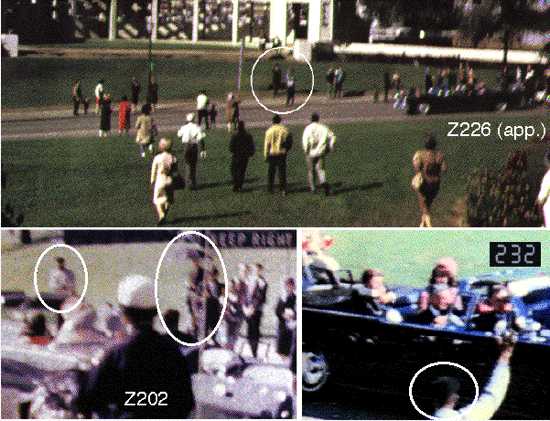
On the day that John F. Kennedy was assassinated in Dealey Plaza, dozens of people captured photographic evidence of the murder. The most important evidence was taken by Abraham Zapruder and shows Kennedy’s fatal head shot. In order to determine exactly what happened that day, government officials have examined and scrutinized every angle of the videos. In some cases, mysterious people of interest have been identified. One of the most famous examples is the Babushka Lady, who was witnessed filming near the assassination, but never identified by the police.
Another mysterious figure that was seen during the JFK assassination is the umbrella man. The umbrella man can be seen in several videotapes and photographs of the assassination, including the Zapruder film. He is the only person in Dealey Plaza with an umbrella, which has been deemed unusual because it was a clear day. In the videos, the umbrella man can be seen opening his umbrella and lifting it high above his head as JFK’s limousine approached. He then spun the umbrella clockwise as the limo slowed down and JFK was shot.
In the aftermath of the assassination, the umbrella man sat down on the sidewalk next to the Stemmons Freeway sign. He then got up and walked towards the Texas School Book Depository. The true identity of the umbrella man has never been discovered. His actions have been at the center of multiple movies that examine the JFK conspiracy theory, including Oliver Stone’s film. The theory suggests that the man used the umbrella to signal the shooters. More specifically, he could have been signaling Kennedy’s driver, who was ordered to slow the vehicle. Many people who witnessed the assassination said that Kennedy’s limo came to an almost complete stop in the middle of the street before he was shot.
A less common theory is that the umbrella man used a poison dart to immobilize JFK during the assassination. Another person of interest is the dark-skinned man that is seen standing next to the umbrella man. During the Zapruder film, the dark-skinned man is witnessed making sudden movements toward JFK at frame 202. It almost looks like he makes a Nazi salute motion towards the president. The same dark-skinned man was photographed speaking into a walkie-talkie in Dealey Plaza.
In 1978, after an appeal to the public by the U.S. Committee on Assassinations, a man named Louie Steven Witt came forward and claimed he was the umbrella man. Witt says he brought the umbrella to Dealey Plaza in order to heckle Kennedy. Another theory is that the umbrella man was Cuban American Manuel Artime, who had a close relationship with E. Howard Hunt. Artime died mysteriously in 1977, which is the same time the U.S. assassination committee was investigating the umbrella man.
9
Berkeley Mystery Walls
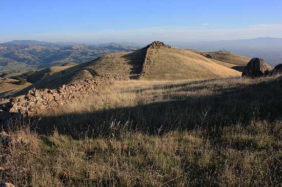
There is a bizarre set of ancient walls that exist in the hills along the East Bay of San Francisco. Little has been written about the walls and their origin. The walls are constructed from closely fit basalt boulders, which serve as the foundation of the structures. The rocks are deeply embedded in the soil and weigh up to 1 ton. The walls extend for many miles along the hill crests from Berkeley to Milpitas and beyond, even all the way to San Jose, which is located 50 miles south. Some of the walls have been destroyed over the years, but large stretches still exist. In some places, the walls twist and turn abruptly and climb large hills. However, they don’t appear to enclose anything or serve a practical purpose.
The walls surround mountains and extend to Mt. Diablo, where people have discovered a strange stone circle that is 30 feet (9.1 meters) in diameter. The best preserved sections of the walls can be found on Monument Peak, which is east of Milpitas, California. In some places the walls have been known to reach the height of 6 feet (1.8 meters) and the width of 3 feet (0.9 meters). In one location the walls form a spiral that is 200 feet (60.9 meters) wide and circles into a boulder. The construction looks old, but no research has been done to determine their precise age. Before Europeans arrived in San Francisco Bay, the Ohlone Indians populated the region, but they didn’t use stone construction.
To the west of San Francisco Bay, there is another rock wall anomaly in Point Reyes that has drawn some attention. It consists of over 400 carefully laid stones that bisect the Tomales Point peninsula. It is currently unclear who created the Berkeley mystery walls, but some feel the structures were used as a defensive stronghold or line between Indian tribes. In 1904, UC-Berkeley professor John Fryer suggested that the walls were made by migrant Chinese, who traveled to California before the Europeans. Some specialists have noted that the walls look similar to other ancient structures found in rural Massachusetts, Vermont, and Maine. Some sections of the Berkeley mystery walls have been torn apart by acorns that fell within cracks, sprouted and became mature trees, and then died and decayed, which indicates the structures have been around for a long time.
8
Apollo 11 Missing Tapes
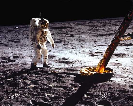
It can be argued that the most important video in the history of man is missing. On July 21, 1969, the live broadcast of Neil Armstrong and Buzz Aldrin walking on the moon was broadcast around the world. Six hundred million people, or one fifth of mankind at the time, watched the event. The video was extremely blurry because of the technological limitations of the time. In 1969, only limited bandwidth was available to transmit the video signal, which needed to be multiplexed back to the Earth, so the video of the Apollo 11 moonwalk was transmitted in a SSTV format of 10 frames per second at 320 lines of resolution.
Originally, the SSTV format was incompatible with existing NTSC, PAL, and SECAM television standards, so the tapes were converted to a different format. During the conversion, the live signal was sent to a high-quality video monitor and the screen was simply re-recorded with a conventional television camera and broadcast to the world. The optical limitations of the monitor and the camera significantly lowered contrast, brightness, and resolution of the original SSTV video. It also put a huge amount of noise in the broadcast.
You would think that NASA would have recognized the huge significance of the original analog tapes in SSTV format and kept them in a temperature controlled and safe environment, but this is not the case. In 2006, the story broke that NASA had lost 700 boxes of magnetic data tapes, including the original SSTV recordings of the moonwalk. The mistake was huge because modern technology could easily allow for the SSTV tapes to be transformed into a higher quality video of the Apollo 11 moon landing. The mistake has only fueled conspiracy theorists who claim the moonwalk was staged.
7
Supernova Remnant G1.9+0.3
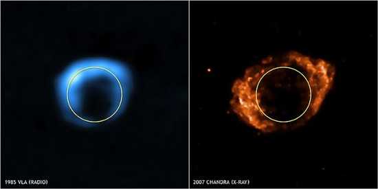
According to NASA, G1.9 can be explained as the youngest known supernova remnant (SNR) in the Milky Way Galaxy. It is said to be only 140 years old, which is extremely young for a SNR. The dating of G1.9 has caused some Russian scientists to question the fact because there is no record of a visible supernova during the 1860s. However, NASA maintains that a substantial increase in the brightness of the object over the last 25 years means it is extremely young. The discovery of G1.9 was announced on May 14, 2008 at a NASA press conference. In the days leading up to the conference, NASA said that it would be “announcing the discovery of an object in our Galaxy astronomers have been hunting for more than 50 years.”
This statement caused some people to infer that G1.9 might be a brown dwarf that is related to Planet X or Nibiru, partly because of the objects elongated orbit which is representative of Nibiru. G1.9 was also originally discovered in 1984, which is the same year that conspiracy theorists claim an abnormal planet was found by the U.S. government. In 2012, a story emerged that a group of Spanish astronomers named the StarViewer Team had discovered an object almost twice the size of Jupiter sitting just beyond Pluto. According to the group, the brown dwarf appeared to have planets or large satellites encircling it. It was referred to as G1.9.
StarViewer reported that the object was formed in the same way as the Sun. The group connected the history of the object to Nemesis, which is a hypothetical hard-to-detect star that was originally postulated in 1984. The Spanish team reported that the brown dwarf is orbiting the Sun at a distance of about 95,000 AU (1.5 light-years) beyond the Oort cloud. In November 2010, the scientific journal Icarus published a paper by astrophysicists John Matese and Daniel Whitmire, which proposed the existence of a binary companion to our Sun, larger than Jupiter, in the Oort cloud. The researchers used the name “Tyche” to describe the planet.
Spanish astronomers have reported that they tracked G1.9 with great interest because of the recent gravitational anomalies in the Oort cloud. In 2010, it was reported that Pluto had recently undergone a change in color, which may be caused by a massive heating event on the former planet. In the past two years, NASA has discovered two new moons around Pluto, which suggests that the system is more crowded than originally thought. These facts have sparked interest from Spanish scientists who suggest G1.9 is influencing Pluto. For the record, according to author Zecharia Sitchin, whatever Nibiru is, won’t get close to Earth before 2030.
6
Malta Cart Ruts
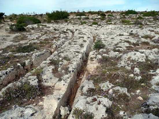
Misrah Ghar il-Kbir (Malta cart tracks) is a prehistoric site located near the Dingli Cliffs on the west coast of Malta. Malta is a Southern European country situated in the center of the Mediterranean Sea, some 80 km (50 mi) south of Sicily. One of the greatest mysteries of Malta is the cart ruts, which are a complex network of tracks that have been carved into the rock. The earliest reference to the tracks was made by Gian Francesco Abela in 1647, who suggested that they were used to transport stones from quarries to the sea for exportation to Africa.
It is currently unclear exactly how the tracks were formed or for what purpose. In general, most archeologists presume that the site was developed around the year 2000 BC when new settlers came from Sicily to Malta. The ruts can be found in a number of sites around Malta and on Gozo. However, near the Dingli Cliffs they form a “traffic jam” and move in all directions. On average, the grooves are up to 60 cm deep and have an average distance of 110 to 140 cm between them. In certain locations, the tracks cross to form a junction, which creates the illusion of a railway station switching yard. For this reason, the site was nicknamed Clapham Junction, after the station in London.
The Malta tracks produce parallel grooves in the bedrock. Some of the grooves extend for several hundred meters in length and travel into the water. In some areas, the tracks move around large rocks and natural formations. A collection of theories have been put forward to explain the ruts, including that they were formed by human sleds. Some have hypothesized that the tracks could be the remnant of an ancient irrigation system. Recent research has suggested that the Malta tracks could have been formed by wooden-wheeled carts that eroded the soft limestone. If true, the ruts could provide evidence for an ancient transportation network in Malta.
5
Wilkes Land Crater
Wilkes Land is a large district of land in eastern Antarctica that was named after Lieutenant Charles Wilkes, who commanded the 1838 United States Exploring Expedition. During the expedition, Wilkes discovered proof that Antarctica is a continent. In 1962, a man named R.A. Schmidt became the first person to propose the theory that a giant impact crater is located beneath the Wilkes Land ice sheet. He based the hypothesis on seismic and gravity anomalies in the area. In 2006, a team of researchers led by Ralph von Frese and Laramie Potts used gravity measurements by NASA’s GRACE satellites to prove that there is a 480 km (300 mi) wide Wilkes Land crater. The enormous crater is centered at 70°S 120°E and was probably formed about 250 million years ago.
The anomaly is centered within a larger ring structure that is visible with radar images. If the feature is an impact crater, then, based on the size of the ring structure, the crater would be four or five times wider than the one that is thought to have caused the Cretaceous–Paleogene extinction event. The impact of the object has also been reported to have disturbed the rift valley that formed 100 million years ago when Australia moved away from the Gondwana supercontinent. For this reason, it has been hypothesized that the impact might have contributed to the massive separation by weakening the crust.
The dates surrounding the Wilkes Land Crater suggest that it might be associated with the Permian-Triassic extinction event, which occurred 250 million years ago and is believed to be the largest extinction event since the origin of complex life. People who doubt the impact theory have noted that there is a lack of an impact ejecta layer associated with the crater. In 2012, it was announced that samples taken from the core of Wilkes Land showed a tropical presence. Researchers were able to reconstruct the local vegetation on Antarctica and found that there were tropical and subtropical rainforests covering the coastal region 52 million years ago. The scientific evaluations showed that winter temperatures on the Wilkes Land coast were warmer than 50 degrees Fahrenheit approximately fifty million years ago.
4
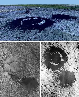
Baltic Sea Anomaly
On June 19, 2011, a Swedish based diving team named Ocean X made a bizarre discovery in the Baltic Sea. The team specializes in the underwater retrieval of valuable artifacts. On the day in question, Ocean X used sonar equipment to identify a “very unusual 197 foot (exactly 60 meter) diameter cylinder shaped object at the depth of approximately 275 feet (83.8 meters).” The team captured a sonar image of the object and released it to the press, which caused some to compare the picture to the Millennium Falcon from Star Wars.
Ocean X founder Peter Lindberg responded by saying “First we thought this was only stone, but this is something else. Since no volcanic activity has ever been reported in the Baltic Sea, the find becomes even stranger.” In 2012, Ocean X returned to the site of the anomaly with a collection of 3D seabed scanners and submersible objects. After reaching the site, the team reported that all their electronic equipment, including a satellite phone would not work within 200 meters of the site. After closer examination, the anomaly was described as a “huge mushroom” with a thick pillar rising 8 meters (26 feet) out of the seabed with a 4 meter (13 foot) thick dome on the top. Ocean X says they observed wall-like features on the formation’s surface, straight lines, right angles, and circular shaped stones.
In July of 2012, it was suggested that the object may be a Nazi anti-submarine defense system that was used during the Second World War, which had wire mesh to confuse British and Russian submarine radar. If the anomaly is an anti-submarine defense system, the discovery could have historical significance. It could also help explain why electrical equipment has been known to not work near the area.
The story has been picked up by ufologists who claim the anomaly is an alien spacecraft or government facility. Initial reports said that the object contained a staircase, passageways, and a small opening. It has also been suggested that the anomaly sits at the end of a large runway. In 2012, a series of articles were published that claimed the object was a pile of rock, while others say it sits below a unique pattern of rocks. The story has been blurred, but many scientists have labeled the object a cluster of rocks or a sediment deposit. The location of the Baltic Sea Anomaly is secret. In 2012, it was reported by Ocean X that a series of U.S. and Russian military exercises were carried out near the anomaly.
3
Vinland Map
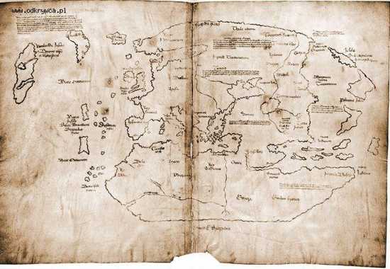
In 1960, a Norse settlement was found at L’Anse aux Meadows, which is located on the northern tip of the island of Newfoundland, in what is now the Canadian province of Newfoundland and Labrador. The discovery provided evidence that the Vikings had entered sections of North America 500 years before Christopher Columbus. According to the Sagas of Icelanders, the great explorer Leif Ericson established a Norse settlement on North America named Vinland around the year 1000. Vinland is mentioned in the work of Adam of Bremen c. 1075 and in the Book of Icelanders compiled c. 1122 by Ari the Wise. According to the books, North America was sighted around 986 by Bjarni Herjolfsson, who was blown off course on a trip from Iceland to Greenland. His stories lured Leif Ericson to the area.
In 1957, news of the Vinland map was released to the world. The map is claimed to be a 15th-century world map that holds unique information about the Norse exploration of America. In addition to showing Africa, Asia, and Europe, the map depicts a landmass south-west of Greenland in the Atlantic Ocean labeled as Vinland. The discovery shocked historians who looked to explain the origin of the map. The parchment of the Vinland map shows a representative date of somewhere between 1423 and 1445. Since the map was found, some people have labeled it a forgery, while others have identified it as real.
In the late 1960s, it was announced that a chemical analyses of the map showed ink ingredients from the 20th-century. More specifically, the presence of anatase, which is a synthetic pigment used since the 1920s, however, natural anatase has been demonstrated in various Mediaeval manuscripts. The situation was made worse by the fact that the map was coated with an unknown substance in the 1950s, possibly created by nuclear tests on the document. To support claims for the map, it has been discovered that the wormholes match a medieval copy of volume 3 of Vincent of Beauvais’s encyclopedic Speculum historiale (“Historical Mirror”), which suggests that it may have been located in the book.
In a bizarre occurrence, the Vinland map depicts Greenland as an island with a remarkably close representation of the correct shape and orientation of the land. However, the depiction of Norway is wildly inaccurate. The map also shows an area that may represent Japan. It seems to not only show Honshu, but also Hokkaido and Sakhalin, which were omitted even from Oriental maps in the 15th century.
Many historians feel that the map might be a copy of one developed by Italian mariner Andrea Bianco in the 1430s. Some have placed the land of Vinland as far south as New England or Rhode Island. To date, the map is said to be real by its current owner, Yale University. Regardless of the controversy over its authenticity, the Vinland map has been valued at over $25,000,000. It might be the first map to show North America.
2
Vitrified Forts
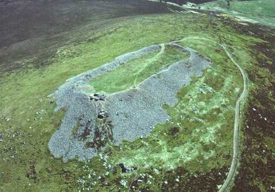
In 1777, a man named John Williams, who was one of the earliest British geologists, described the phenomenon of vitrified forts. Vitrified forts are the name given to a type of crude stone enclosure or wall that shows signs of being subjected to intense heat. The structures have baffled geologists for centuries because people can’t figure out how the rocks were fused together. There is currently no accepted method for the vitrification of large scale objects. “The temperatures required to vitrify the entire fort structures are equal to those found in an atomic bomb detonation.” Hundreds of vitrified fort structures have been found across Europe and 80 such examples exist in Scotland. Some of the most remarkable include Dun Mac Sniachan, Benderloch, Ord Hill, Dun Creich, Castle Point, and Barra Hill.
The forts range in age from the Neolithic to Roman period. The structures are extremely broad and present the appearance of large embankments. The process used to develop the walls is thought to have involved extreme heat and many structures show signs of fire damage. However, vitrification is usually achieved by rapidly cooling a substance. It occurs when bonding between elementary particles becomes higher than a certain threshold. Thermal fluctuations break the bonds, therefore, the lower the temperature, the higher the degree of connectivity. The process of vitrification made headlines in 2012 when scientists used it to preserve organs and tissues at very low temperatures.
Many historians have argued that vitrified forts were subjected to carefully maintained fires to ensure they were hot enough to turn the rock to glass. In order to do this, the temperatures would have been maintained between 1050 and 1235°C, which would have been extremely difficult to do. It is also uncertain why people would have exposed the structures to such intense heat because when rock is superheated, the solid becomes significantly weaker and brittle. Some scientists have theorized that the vitrified forts were created by massive plasma events (solar flares). A plasma event occurs when ionized gas in the atmosphere takes the form of gigantic electrical outbursts, which can melt and vitrify rocks. During solar storms, the Sun is known to occasionally throw off massive spurts of plasma. As of 2012, vitrified forts remain one of the strangest anomalies on Earth.
1
2012 North American Heat Wave
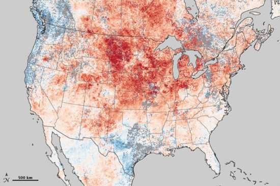
It is not fully understood what is causing the 2012 North American drought, but the bizarre weather patterns have started to impact daily life. The extreme weather started in March of 2012 when over 7,000 high temperature records were shattered in North America, mainly in the U.S. and Canada. At the same time, the western United States and parts of Canada experienced some severe cold weather patterns. In March of 2012, Oregon received a new record for snowfall, while in Chicago the temperatures were 30 degrees hotter than usual.
Mike Halpert, who is the deputy director of the National Oceanic and Atmospheric Climate Prediction Center, called the record-breaking month of March “mind-boggling.” Global warming advocate Bill McKibben said: “it’s not just off the charts. It’s off the wall the charts are tacked to.”
In June of 2012, North America experienced the most deadly and destructive derecho (severe wind and thunderstorm system) in North American history. The derecho resulted in 22 deaths and 3.7 million people lost power for multiple days. In July and August of 2012, North America was thrown into another massive heat wave, which has caused close to 100 deaths in Canada and the U.S. The extreme weather has devastated crops and impacted world economies. In response, the United States has attempted to turn to Russia for help with grain export, but Russia is also experiencing an extreme drought and abnormal weather patterns. As a result, food prices will indefinably rise around the world.
Despite the extremely hot summer temperatures in most U.S. states, places like the Pacific Northwest in Washington State continue to have low temperatures. The bizarre weather patterns have caused some to revisit the Mayan apocalyptic theory. Numerous articles have been published with the suggestion that a very large planet or cluster of comets has started to impact weather on Earth.
The 2012 North American drought has caused catastrophic economic ramifications for the United States and Canada. It is expected to become the most costly disaster in United States history. In July of 2012, an estimated 97% of the top layer of the Greenland ice sheet thawed to some point. It was the largest extent of surface melting observed in three decades of satellite recording. Son Nghiem of NASA’s Jet Propulsion Laboratory responded with the quote: “This was so extraordinary that at first I questioned the result. Was this real or was it due to a data error?” Scientists say that there is a strong correlation between the increased frequency of extreme weather events and the release of human greenhouse gases.
More Great Lists
 Top 10 Things You Need To Know About QAnon
 Top 10 Things You Need To Do To Prepare For The Coronavirus
 Top 10 Essential Facts About The Coronavirus, The…
 Top 10 Films About Economic Disaster You Really Need…
 Top 10 Underappreciated Directorial Debuts You Need To See
 Top 10 Bizarre Musical Genres That You Need In Your Life
 Top 10 Animals That Evolved To Not Need Eyes
 Top 10 Mysteries That Need To Be Solved In 2021
 10 More Historical Events That Sound Too Strange To Be True
fact checked by
Alex Hanton
More Great Lists