 Our World
Our World
Our World  Religion
 10 Forgotten Greek Gods Beyond Olympus
 Crime
Crime 10 Infamous Crime Scenes That Became Tourist Hotspots
 Our World
 10 Rare Hybrids with Wild Backstories
 Space
Space 10 Amazing Explanations for Cosmic Conundrums
 Movies and TV
 10 Film Productions That Went Too Far
 Weird Stuff
 10 Historical Facts That Ruin Your Timeline
 History
 10 Maritime Folktales with a Real-Life Twist
 Crime
Crime 10 Notorious Prison Gangs That Became Criminal Empires
 Music
Music Top 10 Hit Song Lyrics That Became Cultural Catchphrases
Our World 10 Terrifying Forces Scientists Recreated in the Lab
Religion 10 Forgotten Greek Gods Beyond Olympus
Crime 10 Infamous Crime Scenes That Became Tourist Hotspots
Who's Behind Listverse?

Jamie Frater
Head Editor
Jamie founded Listverse due to an insatiable desire to share fascinating, obscure, and bizarre facts. He has been a guest speaker on numerous national radio and television stations and is a five time published author.
More About Us
Our World 10 Rare Hybrids with Wild Backstories
Space 10 Amazing Explanations for Cosmic Conundrums
Movies and TV 10 Film Productions That Went Too Far
Weird Stuff 10 Historical Facts That Ruin Your Timeline
History 10 Maritime Folktales with a Real-Life Twist
Crime 10 Notorious Prison Gangs That Became Criminal Empires
Music Top 10 Hit Song Lyrics That Became Cultural Catchphrases
Top 10 Strange and Unique Forests
Forests cover approximately 9.4% of the Earth’s surface. However, they once covered over 50%. Most people identify forests with trees, but the concept of the forest ecosystem reaches much further and includes many species, such as smaller plants, fungi, bacteria, insects, animals, as well as energy flow and nutrient cycling. Luckily, a large percentage of people on Earth are still able to enjoy the tranquility of an ancient forest. However, some people have never had the chance to enter one of these majestic plant communities. In fact, almost 80% of Europe’s forests are owned by Russia.
As you step foot into an old growth forest, the rush of fresh air fills your lungs. Your senses perk up and you become aware of the life that surrounds you. In the forest, you never know what is waiting around the corner. In the forest, you will discover and witness new things for the first time. In the forest, you will come to peace with nature. In the forest, you will escape the world of technology and learn what it was like to live off the land. This article will examine ten strange and unique forests.
10
North Sentinel Island Forest
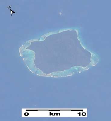
North Sentinel Island is one of the Andaman Islands in the Bay of Bengal. It lies to the west of the southern part of South Andaman Island. North Sentinel Island is unique because it is surrounded by coral reefs and lacks natural harbors. For this reason, the area was never settled by Europeans and deforested. The island is almost completely covered in old growth trees and is 72 km² (27.8 sq mi). Due to the isolation, North Sentinel Island has become home to the last pre-Neolithic tribe known as the Sentinelese.
The Sentinelese tribe consists of 50 to 400 individuals. The group strongly rejects any contact with the outside world. On January 26, 2006, two men were illegally fishing for mud crabs near North Sentinel Island when they were attacked and killed by Sentinelese. The Indian coastguard attempted to recover the bodies using a helicopter, but they were met by a hail of arrows. It was reported that the fisherman’s bodies were buried in shallow graves and not roasted and eaten. However, the idea that the tribe would eat the men is very real.
During the 2004 Indian Ocean earthquake and tsunami, North Sentinel Island was greatly damaged. The tsunami sank some of the surrounding coral reefs and raised others. The coastline of the island was completely demolished. The Sentinelese fishing grounds were disturbed, but the tribe has since adapted to the current conditions. The Sentinelese maintain an essentially hunter-gatherer society, obtaining their subsistence from the forest through hunting, fishing, and collecting wild plants.
Their agricultural practices and methods for producing fire are currently unknown. The Sentinelese weaponry consists of javelins and a flatbow, which has an extremely high accuracy against human-sized targets up to nearly 10 meters (32.8 feet). The Sentinelese has even been known to use untipped arrows for warning shots. There food consists primarily of plantstuffs gathered in the forest, coconuts which are frequently found on the beaches, pigs, and presumably other wildlife (which apart from sea turtles is limited to some smaller birds and invertebrates).
Selected Quote: “I believe our biggest issue is the same issue the whole world is facing, and that’s habitat destruction.” Steve Irwin.
9
Crooked Forest
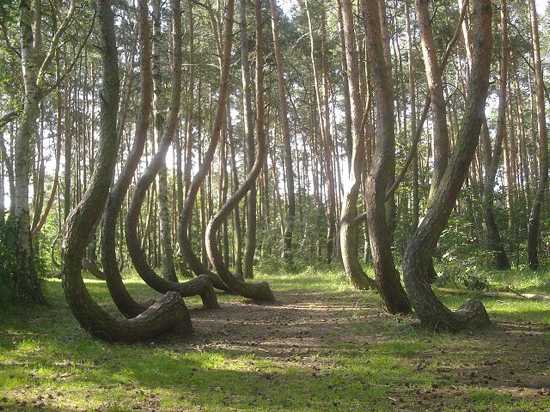
The Crooked Forest is a grove of oddly shaped pine trees located outside the village of Nowe Czarnowo, in western Poland. The forest contains about 400 pine trees that grow with a 90 degree bend at the base of their trunks. All of the trees are bent northward and surrounded by a larger forest of straight-growing pine trees. The crooked trees were planted around 1930 when the area was inside the German province of Pomerania.
It is thought that the trees were formed with a human tool, but the method and motive for creating the grove is not currently known. It appears that the trees were allowed to grow for seven to ten years before being held down and warped by a device. The exact reason why the Germans would want to make crooked trees is unknown, but many people have speculated that they were going to be harvested for bent-wood furniture, the ribs of boat hulls, or yokes for ox-drawn plows. It is a bizarre case that still can’t explain.
Selected Quote: “A chief event of life is the day in which we have encountered a mind that startled us.” Ralph Waldo Emerson.
8
Red Forest
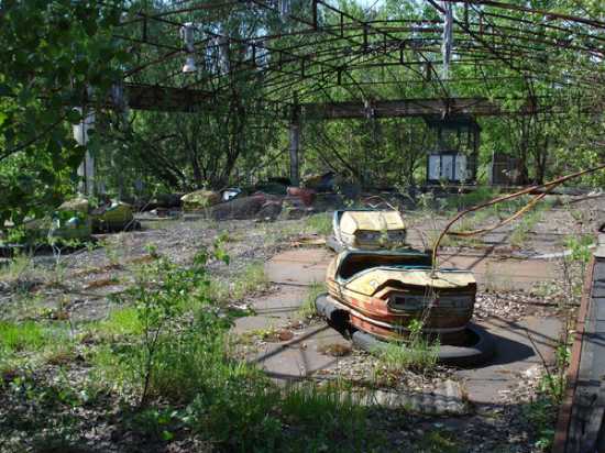
The Red Forest or the Worm Wood Forest is located within the 10 kilometer (6.2 mile) area surrounding the Chernobyl Nuclear Power Plant, near the city of Pripyat, Ukraine. After the Chernobyl nuclear accident on April 26, 1986, the Worm Wood Forest turned a ginger-brown color and died. In the cleanup effort, most of the trees were bulldozed and buried in a collection of “waste graveyards.” The trenches were covered with a carpet of sand and planted over with new pine saplings. Today, the Red Forest remains one of the most contaminated areas in the world. It holds a mixture of old growth pine, along with the new saplings planted in 1986. More than 90% of the radioactivity of the Red Forest is concentrated in the soil.
The accident at Chernobyl has offered scientists an unparalleled opportunity to fully understand the passage of radioactive debris through an urban, rural, and natural environment over time. In a remarkable turn of events, the wildlife in the Red Forest has adapted to the changes and not only survived, but flourished. The forest has been labeled a “Radiological Reserve” and is a hotbed for endangered animals. A large collection of species has moved into the forest and biodiversity in the area has greatly expanded since the accident.
Since 1986, the population of wild boar in the Red Forest has exploded. The area is home to a large collection of wild species, including storks, wolves, beavers, lynx, elk, and eagles. Birds have been observed nesting in the old nuclear reactors and many endangered species have been spotted. In 2001, the tracks of a brown bear were photographed in the streets of Pripyat. In 2002, a young eagle owl, one of only 100 thought to be living in all of Ukraine, was seen on an abandoned excavator in the Red Forest, also an endangered white-tailed eagle was radio-tagged within three miles of the plant. In 2005, a herd of 21 rare Przewalski’s horses escaped from captivity, bred in the area, and have expanded to 64.
The Red Forest still holds some unnatural behavior. The flora and fauna in the area has been dramatically affected by the radioactive contamination. In the years following the disaster, there were many reports of mutant animals, but no cases have been confirmed to influence the genetic evolution of a species, except for the partial albinism in swallows and stunted tail feathers in birds. It should be noted that mutant animals usually die quickly in the wild, so the creatures affected by the explosion are long dead. The Chernobyl Exclusion Zone now encompasses more than 1,600 square miles of northern Ukraine and southern Belarus, a ragged swatch of forests, marshes, lakes, and rivers.
Selected Quote: “A light wind swept over the corn, and all nature laughed in the sunshine.” Anne Bronte.
7
Chestnut Hills
The chestnut blight is a devastating disease that has struck the American chestnut tree and caused the mass extinction of the tree from its historic range in the eastern United States. The disease was accidentally introduced to North America around 1900, either through imported chestnut lumber or through imported chestnut trees. By 1940, almost all of the American chestnut trees were gone. These marvelous trees once grew as tall as 200 feet (61 meters), with a trunk diameter of 14 feet (4.2 meters).
The chestnut tree is known to grow beautiful flowers in late spring or early summer. The blight was caused by the C. parasitica and destroyed about 4 billion American chestnut trees. The fungus kills the tree by entering beneath the bark and killing the cambium all the way round the twig, branch, or trunk. After the blight was first discovered, people attempted to remove the effected trees from the forests, but this proved to be an ineffective solution.
The largest remaining forest of American chestnut trees is named Chestnut Hills and sits near West Salem, Wisconsin. Chestnut Hills holds approximately 2,500 chestnut trees on 60 acres of land. The chestnuts are the descendants from only a dozen trees planted by Martin Hicks in the late 1800s. The trees are located to the west of the natural range of American chestnut, so they initially escaped the onslaught of the chestnut blight. However in 1987, scientists found the fungus in the trees and the blight has been slowly killing the forest. Scientists are working to try and save Chestnut Hills, as there is a strong desire to bring the American chestnut back to the forest.
A large collection of surviving chestnut’s are being bred for a resistance to the blight by The American Chestnut Foundation, which aims to reintroduce a blight-resistant American chestnut to its original forest range in the early 21st century. The disease is local to a range, so it is possible for some isolated trees to exist if no other chestnuts with the blight are within 10 kilometers (6.2 miles). A small stand of surviving American chestnuts was found in F. D. Roosevelt State Park near Warm Springs, Georgia on April 22, 2006.
Selected Quote: “Under the spreading chestnut tree I sold you and you sold me: There lie they, and here lie we, under the spreading chestnut tree.” George Orwell.
6
Sea of Trees
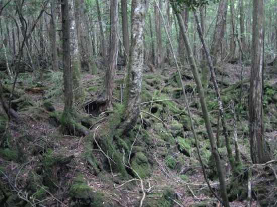
The Sea of Trees or Aokigahara is a forest located at the northwest base of Mount Fuji in Japan. The forest contains a number of hidden caverns and giant trees. It is very dark and has thick growth, so the only light that can be seen inside the forest is a collection of sunbeams. Aokigahara holds an absence of wildlife and is known for being an eerily quiet place. In modern times, the Sea of Trees has gained a reputation for two things, a breathtaking view of Mount Fuji and suicides. There is currently no reliable statistics for the total number of suicides in the forest. However in 2004, 108 dead bodies were found in Aokigahara.
In recent years, the Japanese government has stopped publicizing the number of suicides in the forest. In 2010, it was reported that 247 people attempted suicide in the Sea of Trees, but only 54 succeeded. The suicide rate has caused officials to place signs in the forest, in Japanese and English, which urge people to reconsider their actions. Every year, a collection of police and volunteers conduct an annual body search of the land. During the event, corpses are always discovered, usually hanging from the trees. The Sea of Trees is reportedly the world’s second most popular suicide location after San Francisco’s Golden Gate Bridge.
Japan’s suicide rate is a major problem and has been rising after the 2011 Great East Japan earthquake and tsunami. The country has been experiencing a large wave of social withdrawal. Hikikomori is a Japanese term that refers to the phenomenon of reclusive adolescents or young adults who have chosen to withdraw from social life, often seeking extreme degrees of isolation. It is estimated that around 1% of the entire Japanese population is living as hikikomori. In Japanese mythology, the Sea of Trees has always been linked with morbid myths and legends. It is widely believed that the custom of ubasute, where an elderly relative is left to die in a remote location, was widely practiced in the forest.
Selected Quote: “The prevalence of suicide, without doubt, is a test of height in civilization; it means that the population is winding up its nervous and intellectual system to the utmost point of tension and that sometimes it snaps.” Henry Ellis.
5
Trillemarka – Rollagsfjell Forest
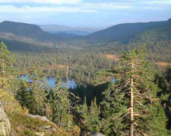
Trillemarka – Rollagsfjell is a 147 km² (57 sq mi) nature reserve located in Buskerud, Norway. It was created on December 13, 2002 and is located in the mountain areas between Nore in Numedal and Solevann in Sigdal. Trillemarka – Rollagsfjell holds the last ancient wilderness forests of Norway. The land has all the qualities of the original Norwegian forests, including untouched valleys, rivers, lakes, and very old trees. Trillemarka – Rollagsfjell is home to 93 red list and endangered species.
Trillemarka – Rollagsfjell holds a large amount of animals that are dependent on the forest dynamics. The area is one of the few untouched woodlands in Norway. Some of the endangered species that frequent the forest are the Lesser Spotted Woodpecker, Tree-toed Woodpecker, Siberian Jay, Stock Dove, and Golden Eagle. The forest is also home to endangered lichens, mosses, and fungi. Currently, about 75% of Trillemarka – Rollagsfjell has been protected by the government, and there is a controversy in Norway over how much of the remaining land should be set aside for future generations. It appears that Norway is lagging behind neighboring countries in forest protection.
Selected Quote: “A nation that destroys its soils destroys itself. Forests are the lungs of our land, purifying the air and giving fresh strength to our people.” Franklin D. Roosevelt.
4
Dark Entry Forest
Dudley Town (the Village of the Damned) is a ghost town in Cornwall, Connecticut. It was founded as a small settlement in the mid-1740s and was a thriving community by the 18th century, known as Owlsbury. The town was primarily fueled by the region’s iron industry. It was a popular place to visit until people started to report strange sightings, unexplained murders, and mass suicides. In some cases, the town residents experienced hallucinations which included demons who commanded them to commit suicide. It was also a regular occurrence for sheep and heard animals to go missing in the town.
Many early settlers of Dudley Town began to think the area was cursed. By the middle of the 20th century, everyone in the town had either died or moved away. Today, Dudley Town looks like it did when Thomas Griffis first settled it some 250 years ago. It is a very thick forest with rocky terrain and it sits in the shadow of three separate mountains: Bald Mountain, Woodbury Mountain, and The Coltsfoot Triplets. Because of the dense and tall woods, the forest has been given the name “Dark Entry Forest.” The land is not officially located in a Connecticut state forest, but sits on private land near the Mohawk State Forest and Mohawk Trail.
The ruins of Dudley Town and the Dark Entry Forest are patrolled by the Dark Entry Forest group, which prosecutes anyone who trespasses on the land. Hundreds of people have been arrested for visiting the site. The area is also known for a large collection of orbs, unexplained lights, and bizarre sounds. Similar to other strange forests, visitors claim that the trees are unusually quiet and without wildlife. Contemporary researchers have suggested that the town may have succumbed to mass hysteria or that the groundwater could have been contaminated with lead which caused the deaths.
Selected Quote: “An idea, like a ghost, must be spoken to a little before it will explain itself.” Charles Dickens.
3
Ardennes
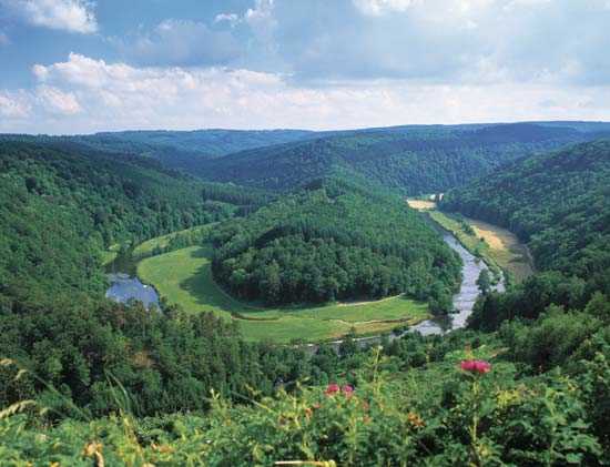
The Ardennes is a region of extensive forests, rolling hills and ridges in Belgium, Luxembourg, and France. The land is covered by thick forests and rugged terrain. The region is rich in timber, minerals, and wild game. The Ardennes holds a strategic position in Europe. For this reason, a large number of famous battles have been fought on the land. The Ardennes has changed hands on many different occasions. In the 20th century, the Ardennes was thought unsuitable for large-scale military operations, but in both World War I and World War II, Germany successfully gambled on making a passage through the area to attack France.
The Ardennes was the site of three major battles in the 20th century, the Battle of the Ardennes (1914), the Battle of France (1940), and the Battle of the Bulge (1944). During the Battle of the Ardennes, French and German troops literally stumbled into each other on the battlefield due to the thick fog. In the winter of 1944, the Third Reich launched a major offensive through the densely forested Ardennes mountain region of Wallonia in Belgium. The event has become known as the Battle of the Bulge.
Before the Battle of the Bulge, the snow-covered Ardennes was so quiet it was termed “the Ghost Front.” The United States placed its greenest units on the wooded hills, along with combat-shattered troops. Hitler valued the Ardennes and arranged for two full Panzer armies and 300,000 troops to conduct a surprise attack designed to shatter the American front. Many of the towns in the region were badly damaged during the battle, including the historic city of La Roche-en-Ardenne. The forest wasn’t completely taken back from Nazi rule until early 1945. Today, the beauty of the Ardennes and its wide variety of outdoor activities, including hunting, cycling, walking, canoeing, and historic landmarks make it a popular tourist destination.
Selected Quote: “Everything in war is very simple. But the simplest thing is difficult.” Karl Von Clausewitz.
2
Hoia-Baciu Forest
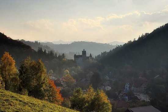
The Hoia-Baciu Forest is located near Cluj-Napoca, Romania and is locally referred to as the Bermuda Triangle of Romania. The forest was named after a shepherd that disappeared in the area with two hundred sheep. Most people who live near the forest are afraid to enter. They believe that those who visit the site will never return. Many of the locals who have gone into the forest complain of physical harm, including rashes, nausea, vomiting, migraines, burns, scratches, anxiety, and other unusual bodily sensations.
The Hoia-Baciu Forest has a reputation for paranormal activity. People have witnessed several strange events on the land. The most common phenomenon includes seeing mysterious orb-like lights, female voices, giggling, apparitions, and cases of people being scratched. In the 1970s, the area was a hotbed for UFO sighting and unexplained lights. Visitors to the forest have reported a strong sense of anxiety and the feeling of being watched. The local vegetation in the forest is bizarre and some trees hold an unexplained charring. On August 18, 1968, a military technician named Emil Barnea captured a famous photograph of a saucer-like object over the Hoia-Baciu Forest.
Many people who live near the Hoia-Baciu Forest have reported a large collection of orb-like lights inside the tree line. When using a thermal, these lights don’t seem to be producing any heat signatures. Some people who enter the forest suddenly remember all of their past experiences in the trees, but then forget the memories after leaving the land. Specialists from around the world are fascinated by the forest. Scientists from Germany, France, the United States, and Hungary have managed to capture bizarre material structures on film, including faces and apparitions. Some of the structures are seen with the naked eye and others only in photos or videos.
Selected Quote: “Authoritarian political ideologies have a vested interest in promoting fear, a sense of the imminence of takeover by aliens and real diseases are useful material.” Susan Sontag.
1
Ancient Wuda Forest
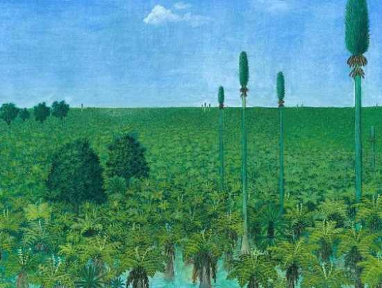
In February of 2012, scientists in northern China announced that they had finished reconstructing an ancient forest that was found buried under a thick layer of volcanic ash near the Mongolian district of Wuda. The 20 square kilometer (12.4 mile) forest was completely preserved after a large volcano erupted 298 million years ago and dropped a large amount of lava and ash on the site. The discovery was reminiscent of the destruction of the Roman city of Pompeii in A.D. 79. It was determined that the blast came from a large volcano around 100 kilometers away. The destruction left a layer of ash that is now 66-cm (about 40 inches) thick. The blast ripped leaves from branches, knocked down trees, and buried the forest.
Scientists from the University of Pennsylvania, Shenyang Normal University, and Yunnan University have been able to reconstruct 10,000 square feet (3,048 meters) of the subtropical forest. They have identified a large collection of plant species and flora that has been extinct for centuries. It is believed that the forest sat on the edge of a large tropical island off Pangaea’s eastern shore. It was swampy land, with a layer of peat and a few inches of standing water. In all, six different species of trees have been identified in the preserved forest, including the tall Sigillaria, Cordaites, and the smaller spore-bearing Noeggerathiales, which is believed to be related to the fern family. Scientists haven’t found any evidence for animal life, such as ancient amphibians.
Selected Quote: “All this worldly wisdom was once the unamiable heresy of some wise man.” Henry David Thoreau.
+
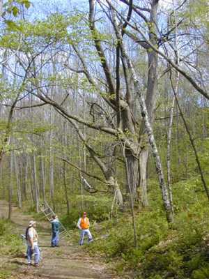
Yellowwood State Forest
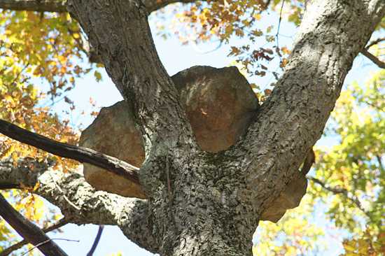
Yellowwood State Forest is located in Brown County, Indiana. The name of the forest is derived from the yellowwood, a tree seldom found this far north in the U.S. The Yellowwood State Forest preserve was established in the 1930s. In 1939, a 133-acre (54 ha) lake, Yellowwood Lake, was created in the area. One major mystery surrounds the forest. A collection of large sandstone boulders, estimated to weigh about 400 pounds (180 kg), have been found in the tops of three trees. The mystery began in the 1990s, when a turkey hunter, scouting in a remote area of the 23,000-acre forest, discovered a large boulder in a chestnut oak tree. The boulder was eventually dubbed Gobbler’s Rock.
Gobbler’s Rock sits high on a south-facing slope overlooking a ravine near Tulip Tree Road in western Brown County. Officials can’t explain how the boulders got wedged into the branches. Some of the theories include a fraternity prank, tornadoes, high winds, or floods. The strange phenomenon is now the focus of several UFO websites. On Yellowwood State Forest’s Wikipedia page it claims that the rocks were placed there by a U.S. helicopter doing a training exercise from nearby Camp Atterbury during World War II. However, the provided reference for the claim is broken and no further information can be found on the training exercise or why such a task would be undertaken.
Selected Quote: “Geologists have a saying, rocks remember.” Neil Armstrong.
More Great Lists
 10 Forests In Britain That You Wouldn't Enter At Night
 10 Unique Tattoo Pieces And Tattooing Traditions
 Top 10 Strange And Scary Facts About Microplastics
 Top 10 Strange And Scary Facts About Moons
 Top 10 Strange Mysteries And Facts About Color
 Top 10 Strange And Scary Psychological Effects
 Top 10 Strange Radioactive Facts And Stories
 Facts About Synthetic Inventions") Top 10 Strange (And Revolting) Facts About Synthetic…
Top 10 Strange (And Revolting) Facts About Synthetic… 10 Unique Halloween Traditions From Around The World
fact checked by
Alex Hanton
More Great Lists