 Crime
Crime
Crime
Crime 10 Hilariously Over-Engineered Solutions to Simple Problems
 Miscellaneous
 10 Ironic News Stories Straight out of an Alanis Morissette Song
 Politics
 10 Lesser-Known Far-Right Groups of the 21st Century
 History
 Ten Revealing Facts about Daily Domestic Life in the Old West
 Weird Stuff
 10 Everyday Products Surprisingly Made by Inmates
 Movies and TV
 10 Actors Dragged out of Retirement for One Key Role
 Creepy
 10 Lesser-Known Shapeshifter Legends from Around the World
 Animals
 10 Amazing Animal Tales from the Ancient World
 Gaming
 10 Game Characters Everyone Hated Playing
Crime 10 Terrifying Serial Killers from Centuries Ago
10 Hilariously Over-Engineered Solutions to Simple Problems
Miscellaneous 10 Ironic News Stories Straight out of an Alanis Morissette Song
Who's Behind Listverse?

Jamie Frater
Head Editor
Jamie founded Listverse due to an insatiable desire to share fascinating, obscure, and bizarre facts. He has been a guest speaker on numerous national radio and television stations and is a five time published author.
More About Us
Politics 10 Lesser-Known Far-Right Groups of the 21st Century
History Ten Revealing Facts about Daily Domestic Life in the Old West
Weird Stuff 10 Everyday Products Surprisingly Made by Inmates
Movies and TV 10 Actors Dragged out of Retirement for One Key Role
Creepy 10 Lesser-Known Shapeshifter Legends from Around the World
Animals 10 Amazing Animal Tales from the Ancient World
Gaming 10 Game Characters Everyone Hated Playing
Ten Positively Insane Facts about the Sahara Desert
What’s the first thing you think of when you hear the word “desert?” It’s the Sahara Desert that immediately springs to mind, right? After all, the Sahara is one of the world’s largest deserts—but most well-known desert—covering darn near the entire top third of the continent of Africa. The thought is that the entire thing is filled with massive sand dunes, teams of camels making long, difficult treks, and thousands of square miles of pretty much nothing except for that sand, the wind, and incredibly inhospitable conditions.
And, well, that’s sort of right (in places, at least), but the entire Sahara Desert is not exactly like the picture that probably springs into your head. In reality, this ancient desert has quite a few fascinating tidbits about it that you wouldn’t expect! In this list, we’ll take a look at ten of those facts. Here’s a rundown of ten amazing and unexpected pieces of information about the Sahara Desert that most people don’t know!
Related: Top 10 Places That Prove Our World Can Be Weird as Hell
10 It Really Is Massive
Sahara Desert – How Big Is The Sahara Desert Actually?
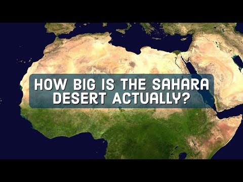
We weren’t kidding up top when we said the Sahara Desert covered “darn near the entire top third of the continent of Africa.” Our comment there was actually right on point—because the Sahara covers exactly 31% of the African continent! In total, the Sahara is spread out over an area of about 3.5 million square miles (9.2 million square kilometers for those not in the United States).
At its widest point from north to south, the Sahara runs more than 1,100 miles (1,800 kilometers) in length, and widthwise, from east to west, it covers roughly 3,000 miles (over 4,800 kilometers). So, when overlaid above the contiguous United States, the Sahara Desert nearly matches it in greatest north-south distance and actually exceeds its midpoint east to west. That’s a HUGE desert!
It’s not just the square mileage itself that gives pause, either. The largest sand dunes within the Western Sahara Desert stretch high up into the sky, as well. The biggest ones are regularly over 500 feet (152 meters) tall, with the very tallest topping 600 feet (183 meters). That’s quite a climb for any man or beast unlucky enough to be caught in the middle of that sandy situation.
Taken all together, the Sahara is actually the world’s third-largest desert. That seems like a strange note after our size comparisons here, but you might be surprised to know the two areas that beat it: Antarctica and the Arctic. So, basically, in terms of “hot” deserts (as in, not ice!), the Sahara has won.[1]
9 It Isn’t All Sand
The Sahara desert | Ecosystems
It’s natural to think that the Sahara Desert is just one big, long stretch of sand dunes. But that actually couldn’t be further from the truth! In reality, the sand seas that you think of when the stereotype of the Sahara Desert comes to mind are actually only part of a very small portion of the area. These sand seas, which are called “ergs” by scientists, make up a big chunk of the far western reaches of the desert, mostly in Western Sahara, Morocco, Mauritania, and the far western part of Algeria.
When you move east through the Sahara Desert, you actually find quite a few different habitats beyond giant sand dunes. There are stone plateaus known as “hamadas” across much of the Sahara eastward, as well as gravel plains known as “regs,” countless dried-up lakes, some deep, desolate valleys, and even areas with major salt flats.
And there are mountains! The Sahara Desert is ringed in nearly every direction by various mountain ranges. In northern Niger, the Air Mountains pop up in the middle of the desert. In southern Algeria, the Hoggar Range does, too. Chad and Libya share the Tibesti Range, nearly smack-dab in the center of the desert. Egypt and Sudan have the Red Sea Hills that make up part of the border between those two nations. And there’s even a dormant volcano in the Sahara Desert—Chad’s Emi Koussi—which is also the region’s highest peak. Now, these aren’t snow-capped peaks like the Rocky Mountains or the Alps, but the terrain is way different than the long stretches of sand dunes you might have assumed.[2]
8 The Eye of the Sahara
Weird Places: Mauritania’s Eye of the Sahara
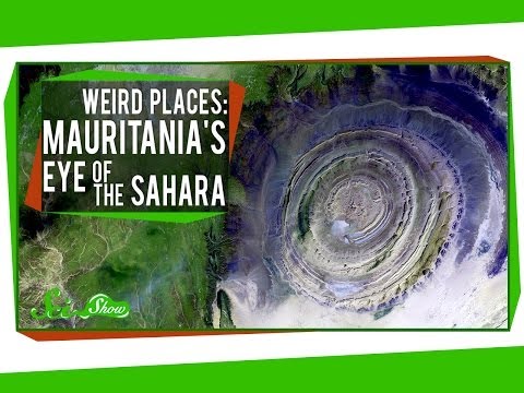
A geological formation known as the Richat Structure is one of the most unique aspects of the Sahara Desert—and scientists aren’t entirely sure what it is. Located in a rural part of Mauritania, the Richat Structure is a natural dome that is made up of many layers of sedimentary rock. This rock is laid out in perfect circles, giving the area the look of an eye when viewed from high above the ground. Scientists first discovered the region in the 1930s and began studying it to see what it was all about. At first, they believed a meteor crashing into the earth millions of years ago had likely caused the circular look to the land. But lately, that hypothesis has come under question.
In the 2000s, evidence proved that it was definitely not a meteor that created the “Eye of the Sahara.” But geologists and the like still aren’t exactly sure why it is there. Some say hydrothermal waters built up in that area in the past and caused the unique rock formations and sedimentary baking. Now, the prevailing theory is that the Eye of the Sahara is, in fact, an uplifted geologic dome, or what scientists call a “domed anticline.” Regardless, it looks really cool from the sky![3]
7 The Sahara Is Half the Story
How Africa’s Great Green Wall Will Make the Sahel Green Again
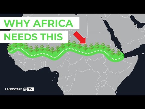
At the bottom of the Sahara Desert, lining it along the southern edge in nations like Burkina Faso, South Sudan, Chad, Nigeria, and Mali is something called the “Sahel.” Yes, the word is very similar to Sahara (and we’ll get to that in a second), but the Sahel is its own fascinating natural ecosystem that doesn’t get nearly as much attention as the Sahara does, even though it should.
The Sahel is a tropical savanna grassland that can get very wet, green, and lively during the rainy season and very dry and desolate during times of drought. Just like the Sahara, the Sahel stretches nearly coast-to-coast across Africa and serves as the border region between the harshest climates of the Sahara and the far more tropical reaches of the continent as it moves south toward the Equator.
In fact, the name “Sahel” is the Arabic word for “coast” or “shore.” That’s a purposeful choice. Not because the Sahel touches the coast—only very small portions of it actually reach the Atlantic Ocean and/or Red Sea—but because the Sahel functions essentially as the “shore” of the Sahara Desert as it meets the rest of civilization to its south. Still, other linguists note that the Arabic word “sahl,” which means “plain,” is the root for the term Sahel.
In either case, the result is the same: The Sahel is a critical buffer zone that holds the harsh Sahara back from far more temperate and even lush regions of natural growth and diverse habitats. In that way, the massive and elongated Sahel is a critical region for farmers, ranchers, and other people and animals relying on the land to survive who are unable to do so in the depths of the desert to its north.[4]
6 A Really Old Mummy
The Mystery Of The Extraordinary Black Mummy | The Tashwinat Mummy
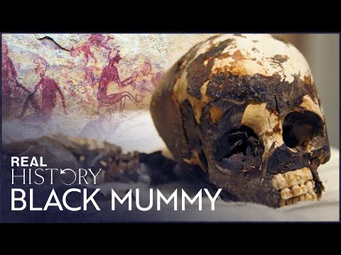
The oldest mummy in the world was found in the Sahara Desert—and it had nothing to do with ancient Egyptian civilization. Commonly called the Tashwinat Mummy, this mummified body of a young child was found by an Italian archaeologist and professor named Fabrizio Mori at the Uan Muhuggiag in Libya way back in 1958. At that site, the mummy discovered was that of a two- or three-year-old boy who had been wrapped carefully in leaves and then tightly wound in antelope skin.
His organs had been removed prior to his burial in the desert, too, and primitive preservatives were found to have been injected into his body in order to maintain it as best they could at the time. Considering the mummy was found literally thousands of years later, it appears those ancient desert dwellers did a pretty good job in that regard.
Carbon dating puts the body at having passed away right around the year 3000 BC. That’s an incredible find because that means that the Tashwinat Mummy is about a thousand years older than the oldest-known ancient Egyptian mummies that have been found by archaeologists throughout that neighboring country.
The boy and his brethren, who lived more than 5,000 years ago, were thought to be cattle herders who roamed around the Sahara with their livestock. At the time, the Sahara was more of a grassland than a desert, and the thought is that primitive civilizations could have conceivably survived long stretches within.[5]
5 Desert Civilizations Flourished
The Garamantes: Rome’s Neighbors in the Sahara
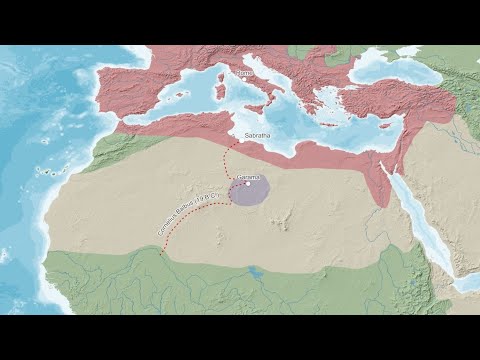
While the Ancient Greeks and Ancient Romans were dominating the European area in terms of either land control or cultural capital in their respective reigns, they weren’t the only civilizations flourishing in the hemisphere. Down south of the Mediterranean, right smack-dab in the middle of the Sahara Desert, several notable ancient civilizations rose up and prospered before dying out and being subsumed into other cultures.
Chief among these was a group of people known as the Garamantes. These people rose up to power in what is now known as Libya in about 500 BC and controlled the region for the next thousand years. They survived in the middle of the desert by digging deep wells down into the earth. There, they could get water for their fields, allowing crops to grow and life to survive and then thrive in what otherwise should have been an extremely inhospitable place.
Interestingly, both the Greeks and the Romans thought very little of the Garamantes during their run in the Sahara, and the Romans even conquered them at one point. The Garamantes’ neighbors to the north believed these desert people to be uncivilized nomads and not worthy of serious consideration as potential allies or threats.
But while the Garamantes were indeed semi-nomadic, the insult to their civilization is a bit over the top. They built structures, created art, formed communities, and ended up succeeding at living in one of the harshest climates in the world. Sadly, it all came to an end for them, though. In the 7th century AD, their wells started drying up, their water supply dwindled to nothing, and they were forced to leave the desert and merge with (and/or be taken over by) the cultures of people who had been living in more hospitable areas around them.[6]
4 Nomads Still Roam There, Too
Berbers: Ancient Origins of North African Civilization
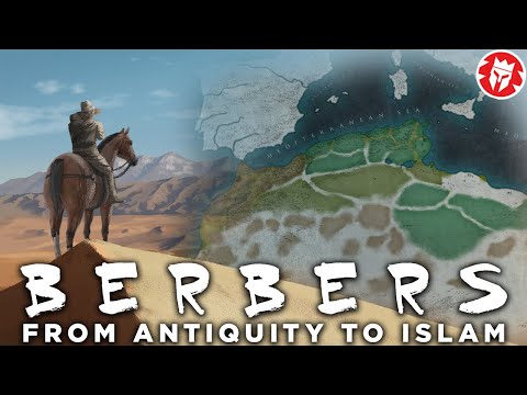
It seems hard to believe this in the modern era of smartphones and perennial internet connectivity, but there are still nomadic tribes who trek all throughout the Sahara Desert today. The most notable of these are two groups: the Berbers and the Tuareg. The Berbers are the oldest of these tribes, with their bloodline dating back possibly as far back as 10,000 BC. In fact, many archaeologists think the ancient Berbers were the very first nomadic peoples who originally inhabited the Sahara.
Today, they live in small, scattered communities all across the region. The nations of Morocco, Libya, Tunisia, Mali, and even Egypt all host various Berber populations. And since they are nomadic in their work with animals and search for water, they often cross international borders to survive.
The Tuareg are well-known inhabitants of the western part of the Sahara Desert and are often seen as a sub-group of the aforementioned Berbers. They have worked very hard to preserve their traditional ways of life, with families setting up camps and moving around at various times of the year for better access to water and food. Some have turned to living a semi-nomadic life, too, by creating slightly more developed urban centers as home bases from which they set out at certain times to camp elsewhere as pastoralists.[7]
3 The Sea That Could Have Been
Sahara Sea: The Insane Plan to Create a Sea in the Sahara Dessert

While the Sahara Desert has always been a sandy, dry place (at least as far as the modern world is concerned), some people have wanted to alter it. In the late 19th century, entrepreneurs and scientists alike started wondering about the feasibility of flooding the Sahara Desert with water and creating the Sahara Sea out of it.
This plan kicked off in 1877 when a Scottish businessman named Donald Mackenzie pondered whether it was possible to cut a channel from the desert out to a nearby ocean and flood a large portion of the Sahara with seawater. That, in turn, could do a few things, according to Mackenzie: It would allow for far more agricultural activity in North Africa, and if the sea were made large enough, it might even alter the weather patterns in Europe and elsewhere.
For Mackenzie, he also wanted the sea cut out of the Sahara Desert for economic purposes. He thought that there had once been a sea there ages ago, and having a manmade one return to the desert could open up new markets for traders coming down from Europe. Specifically, the inland sea could be directed to create a path down to West Africa, where there was plenty of gold and other mineral and timber resources to be exploited. That canal could even connect to the Niger River, Mackenzie believed, which would then open up all the rest of sub-Saharan Africa to more accessible trade routes and relations.
Of course, the Sahara Sea never happened. But it wasn’t for lack of thought on Mackenzie’s part! Other businessmen and scientists even kicked around the idea well into the 20th century, taking time to map out possible entry points and consider how the ocean water might fill in various parts of the desert if given the opportunity.[8]
2 Highways to Hell
The Insane Engineering of the Trans African Highway: A Death Trap?
To be fair to Donald Mackenzie, maybe he was right to think about creating the Sahara Sea in order to make trade easier all across North Africa. That’s because today, while there are overland paved desert routes that can get you traveling by car, bus, or truck along much of the Sahara, nothing is standardized or complete from coast to coast.
Several nations that make up the Sahara Desert have put together very ambitious construction projects aimed at linking disparate places far out in the middle of the sand. And some of those projects have even been seen to fruition—most notably several major highways that run across the entire desert in places like Egypt and Sudan.
But elsewhere in the Sahara, road travel is (as to be expected) far more spotty. There are a couple incredible highway projects that go the length of the continent, though. One highway links Dakar, Senegal, in the far west to Cairo, Egypt, in the far northeast. Another is the Trans-Sahara Highway, which runs through Algeria, Niger, and Nigeria. And while that highway generally skirts the northern edge of the desert, it certainly counts as an impressive and formidable move.
Another highway goal for the continent has been to link Tripoli, Libya, in the far north, with Cape Town, South Africa, in the far south. That highway has run into a number of problems, and not just in the Sahara; the jungles of the Congo and elsewhere don’t make road travel very easy, either![9]
1 The Sahara Is Growing—Quickly
How Africa Plans To Stop The Sahara From Spreading
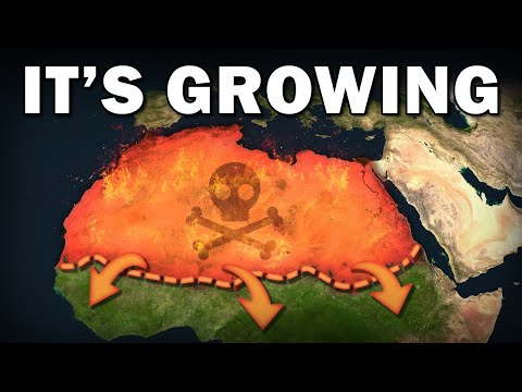
It’s weird to think about a desert as a living thing, and while it’s not—at least not in the same way as we might be thought of as “living”—it is very much a moving, changing, and ever-evolving region. To that end, perhaps it will surprise you to learn that the Sahara Desert right now is about 10% bigger than it was a hundred years ago!
There are a few factors at play in its growth, both related to natural climate cycles and the effects of manmade climate change. So, it’s not totally weird that the desert is taking on new land (especially to the south) and encroaching upon the Sahel and other grasslands. What’s worrisome is what this growth may mean soon for Africa.
Already, the Sahara Desert—and even more so the Sahel to the direct south of it—are war-torn, lawless, and generally dangerous regions. With the desert quickly expanding southward and gobbling up formerly arable land at an unprecedented rate, these issues will persist and expand.
Nations like Mali, Mauritania, Burkina Faso, and others are seeing increasing rates of jihadist insurgency and terrorist activity for many reasons. The expanding desert putting pressure on communities to even survive in increasingly harsh conditions will quickly create a flashpoint. To that end, the immediate futures of many of the people living on the outskirts of the Sahara Desert are bleak, to say the least.[10]
More Great Lists
 Ten Insane Things That Got Women Accused of Witchcraft
 Ten Absolutely Insane Conspiracy Theories about…
 10 Insane Movie Facts You Will Not Believe Are Real
 10 Absolutely Insane Facts You Didn't Know About Your Penis
 Top 10 Insane Moments In Rock History - 2020
 Top 10 Board Games That Take An Insane Amount Of…
 10 Celebrities Who Were Declared Insane
 10 Worthless Items Sold for an Insane Amount of Money
 Top 10 Insane Video Game Premises
fact checked by
Darci Heikkinen
More Great Lists