 Mysteries
Mysteries
Mysteries  Our World
 10 Countries Where Water Scarcity Gets Seriously Weird
 Weird Stuff
 10 of the Most Bizarre Buildings Around the World
 Creepy
 10 American Urban Legends Far Stranger Than Bigfoot
 Movies and TV
 10 Radical Reimaginings of Frankenstein
 Facts
Facts 10 Explosive Facts You Probably Don’t Know About Volcanoes
 Pop Culture
 0 Things That Became Massive Hits the Second Time Around
 Humans
 History’s 10 Little-Remembered Acts of Charity
 The Arts
 10 Iconic Masterpieces Attacked by Pure Pettiness
 History
 History’s Ten Most Lopsided Battles Ever
Mysteries 10 People Who Infamously Appeared out of Nowhere
Our World 10 Countries Where Water Scarcity Gets Seriously Weird
Weird Stuff 10 of the Most Bizarre Buildings Around the World
Who's Behind Listverse?

Jamie Frater
Head Editor
Jamie founded Listverse due to an insatiable desire to share fascinating, obscure, and bizarre facts. He has been a guest speaker on numerous national radio and television stations and is a five time published author.
More About Us
Creepy 10 American Urban Legends Far Stranger Than Bigfoot
Movies and TV 10 Radical Reimaginings of Frankenstein
Facts 10 Explosive Facts You Probably Don’t Know About Volcanoes
Pop Culture 0 Things That Became Massive Hits the Second Time Around
Humans History’s 10 Little-Remembered Acts of Charity
The Arts 10 Iconic Masterpieces Attacked by Pure Pettiness
History History’s Ten Most Lopsided Battles Ever
10 Places with Geological Features That Shouldn’t Exist
The Earth is not supposed to surprise us anymore.
We have mapped its continents, measured its mountains, and photographed its surface from orbit. Satellites track storms in real time. Drones peer into craters. Deep-sea submersibles explore its trenches. In theory, there should be no room left for landscapes that look like mistakes.
And yet, they exist.
Across the planet are places that seem to defy how geology “should” behave. Lakes glow pink. Deserts form perfect bullseyes visible from space. Mountains end abruptly in flat stone tables suspended above the clouds. Glaciers appear to bleed. Coastlines assemble themselves into geometric staircases of interlocking hexagons.
These formations are entirely natural. What makes them unsettling is their precision—symmetry where chaos should reign, color where monotony should dominate, structure where randomness seems more likely. Each location challenges the assumptions we carry about how Earth works. Together, they reveal something humbling: even on a thoroughly studied planet, nature is still capable of producing the improbable.
Related: 10 of the Weirdest Places That Have Been Preserved
10 Salar de Uyuni
Salar de Uyuni: The World’s BIGGEST Mirror
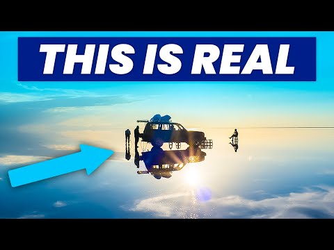
If Earth occasionally feels like a planet assembled incorrectly, Salar de Uyuni would be Exhibit A. Stretching across more than 4,000 square miles (10,000+ km²) in southwestern Bolivia, it is the largest salt flat on the planet. At first glance, it looks less like terrain and more like a rendering glitch—an infinite sheet of blinding white that merges seamlessly with the sky.
During the rainy season, a thin layer of water transforms it into a mirror so flawless that the horizon disappears. Visitors often describe the sensation as walking through the clouds. What makes Salar de Uyuni feel impossible is its scale and uniformity. The elevation variation across the entire salt crust is often less than 3 feet (about 1 meter).
The explanation begins with prehistoric lakes. Roughly 30,000–40,000 years ago, this region was submerged beneath massive bodies of water, including Lake Minchin and later Lake Tauca. When climate patterns shifted, the lakes evaporated, leaving thick mineral deposits that hardened into a salt crust several meters deep.
Beneath that crust lies one of the world’s largest lithium reserves—an element now essential for modern batteries. The surface is fractured into geometric polygonal patterns formed by cycles of evaporation and crystallization. The shapes are entirely natural, yet so symmetrical that they often spark speculation about artificial design.
Salar de Uyuni is not extraterrestrial. But standing on its endless white expanse, it can feel like another world entirely.[1]
9 Richat Structure
MAURITANIA – Traveling to the Center of the Richat Structure ( in 4K)

In the Sahara Desert of Mauritania, a colossal series of concentric rings stretches roughly 25 miles (40 km) across. Known as the Richat Structure—or the “Eye of the Sahara”—it resembles a giant bullseye carved into the Earth. Astronauts have used it as a landmark from orbit.
At first glance, the formation appears engineered. Its near-circular symmetry clashes with expectations of how deserts behave. Early scientists suspected it was an impact crater, but no evidence of shocked minerals or impact debris was found.
The structure is now understood to be a deeply eroded geological dome. Millions of years ago, molten rock pushed upward beneath sedimentary layers without breaking through the surface. Over time, uplifted rock layers eroded at different rates—softer layers wearing away faster than harder ones—leaving the dramatic ringed pattern.
From ground level, the structure is nearly impossible to perceive in full. Only from high altitude does its eerie symmetry become clear. The Earth formed it through uplift and erosion, yet from space it looks deliberately drawn with a compass.[2]
8 Fly Geyser
Amazing Fly Geyser, Exclusive Interview

In Nevada’s Black Rock Desert, a neon-colored fountain of steaming water rises from the earth like a science-fiction prop. Fly Geyser’s mineral towers glow red, green, and orange, while water cascades down terraces resembling melted wax.
The strangest part is that it was never meant to exist. In 1916, a well was drilled in search of irrigation water and later abandoned. In 1964, another geothermal well nearby tapped into superheated water. When the well casing failed, mineral-rich water began spraying into the air. Instead of subsiding, the eruption continued.
Over decades, dissolved minerals—primarily calcium carbonate—accumulated around the vent, forming the growing mound. Thermophilic algae thriving in the hot water produce the vivid coloration. The Geyser has continued expanding for more than half a century and remains active today.
Unlike Yellowstone’s iconic geysers, Fly Geyser was triggered accidentally by human drilling. Yet once unleashed, natural geothermal processes took over. What began as a drilling mishap became one of the desert’s most surreal landmarks—part accident, part geology, part biology.[3]
7 Moeraki Boulders
The Geologic Oddity in New Zealand; Moeraki Boulders

Along Koekohe Beach in New Zealand, enormous stone spheres rest on the sand as though giants once played marbles along the shoreline. Some of the Moeraki Boulders measure more than 6 feet (2 meters) in diameter and weigh several tons.
Their symmetry defies expectation. Rocks are supposed to be jagged; coastlines chaotic. These boulders are near-perfect spheres, etched with geometric crack patterns resembling turtle shells.
The explanation lies in their origin as concretions. Around 60 million years ago, minerals such as calcite crystallized around small cores within layers of marine mudstone on the ancient seafloor. Over millions of years, mineral buildup expanded evenly in all directions, forming spherical masses inside softer rock.
Tectonic uplift later exposed the formations, and coastal erosion freed them from the cliffs. As the concretions dried, they cracked, and calcite filled the fractures, creating the distinctive vein patterns seen today.
They are not artifacts or meteorites. Yet standing among them, their balance and placement feel improbably deliberate.[4]
6 Danxia Landform
How Nature created a Zhangye Danxia
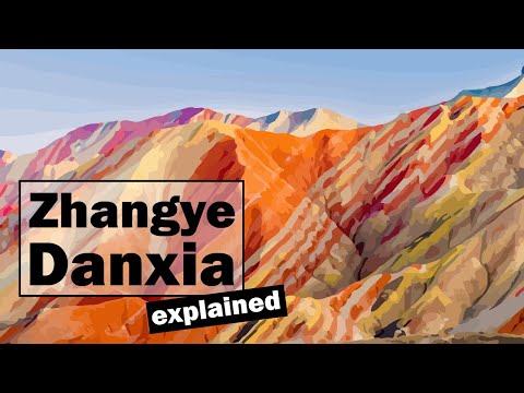
Mountains are not supposed to resemble abstract art. Yet in China’s Zhangye National Geopark, rolling hills display dramatic bands of red, yellow, orange, and white.
These rainbow-like stripes were formed from layers of sandstone and mineral deposits laid down during the Cretaceous period nearly 100 million years ago. Iron oxides produced the deep reds, while other trace minerals created lighter hues. Later tectonic activity folded and tilted the sedimentary layers upward, exposing them.
Wind and rain then sculpted the uplifted rock, smoothing ridges and revealing the vivid banding beneath. The clarity of the striping across such sweeping terrain gives the hills the appearance of layered cake slices arranged by design.
Photographs are often dismissed as over-saturated, but the colors are real. They are the product of iron, pressure, uplift, and erosion collaborating over immense spans of time.
Nature rarely displays its geological layers so boldly. In Zhangye, it does so in full color.[5]
5 Lake Hillier
Weird Places: Australia’s Bright Pink Lake
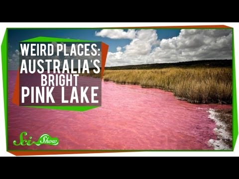
A lake is supposed to reflect the sky—blue on clear days, gray during storms. Lake Hillier refuses to follow that rule.
Located on Middle Island off the coast of Western Australia, this salt lake is an unapologetic bubblegum pink. Not faintly tinted. Not seasonally discolored. Permanently pink. What makes it even stranger is that the color remains stable year-round and persists even when the water is removed and bottled.
The unusual hue results from extreme salinity and the presence of microorganisms. A salt-loving algae called Dunaliella salina produces carotenoid pigments, similar to those found in carrots. Certain halophilic bacteria living in the salt crust contribute additional reddish tones. Together, they saturate the water with its vivid coloration.
The lake sits beside the deep blue Southern Ocean, separated only by a narrow strip of dunes. The contrast is so sharp it looks digitally enhanced. First recorded by European explorers in 1802, Lake Hillier has puzzled observers ever since. It is harmless to touch, though far too salty to drink comfortably.
Water is not supposed to look like paint. And yet, off Australia’s southern coast, one stubbornly does.[6]
4 Giant’s Causeway
The Giant’s Causeway Doesn’t Look Like a Natural Monument
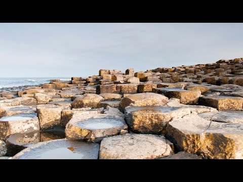
Along the rugged coast of Northern Ireland, roughly 40,000 tightly packed basalt columns rise from the sea like a massive stone staircase. Most are hexagonal. Many fit together with surprising regularity. From a distance, the Giant’s Causeway resembles the ruins of a lost civilization.
The scientific explanation begins with volcanic fire. Around 60 million years ago, basaltic lava flooded the region. As the molten rock cooled, it contracted. When cooling occurs evenly, fractures form in geometric patterns. The most efficient shape for distributing stress is a hexagon, though some columns have five or seven sides.
This process—known as columnar jointing—created interlocking pillars as the lava cooled from the top and bottom simultaneously. Over millions of years, erosion removed surrounding material, exposing the formation.
A handful of geometric cracks might seem ordinary. Tens of thousands arranged along a coastline feel deliberate. Local legend attributes the causeway to the giant Finn McCool, who supposedly built it as a bridge to Scotland. Given the symmetry, mythology feels almost reasonable.
The Earth built this staircase out of cooling lava—and left it facing the sea.[7]
3 Socotra
7 days in Yemen’s Mysterious Island Paradise (SOCOTRA 2025)

Floating in the Arabian Sea off the coast of Yemen, Socotra looks less like part of Earth and more like a set piece from science fiction. Nearly a third of its plant species exist nowhere else on the planet.
The island’s most famous resident, the Dragon’s Blood Tree, spreads its umbrella-shaped canopy above a thick, twisting trunk. When cut, it releases a deep red resin historically used as dye and medicine. The tree’s distinctive form evolved to reduce evaporation and protect seedlings from harsh sunlight.
Socotra separated from mainland Arabia millions of years ago as tectonic plates shifted. Isolation allowed its ecosystems to evolve independently, shaped by extreme dryness and limited freshwater. Over time, species adapted in unusual ways—producing bottle-shaped trunks, alien-looking shrubs, and plant forms rarely seen elsewhere.
The terrain amplifies the otherworldly impression. Limestone plateaus rise sharply above coastal plains. Caves perforate the mountains. White dunes press against turquoise waters. Unusual species are not scattered here—they dominate.
Socotra is entirely natural. But its concentration of endemic life makes it feel like an evolutionary experiment conducted in isolation.[8]
2 Mount Roraima
Join Redfern Adventures’ Lost World of Mount Roraima Expedition

Mountains typically rise to peaks. Mount Roraima ends in a flat stone table suspended above sheer cliffs.
Straddling the borders of Venezuela, Brazil, and Guyana, this massive tabletop mountain—known as a tepui—rises nearly 9,200 feet (2,800 meters) above sea level. Its vertical walls drop hundreds of feet straight down, giving it the appearance of a fortress carved by design.
The sandstone that forms Mount Roraima dates back roughly two billion years, making it one of the oldest exposed geological formations on Earth. The flat summit is the remnant of an ancient plateau that once covered a much larger region. Over immense spans of time, erosion stripped away surrounding rock, leaving isolated mesas behind.
Constant rainfall continues to sculpt the summit, carving pools and strange black rock formations. Carnivorous plants thrive in nutrient-poor soils. Because of its isolation, many species found atop Roraima exist nowhere else.
Its shape inspired Arthur Conan Doyle’s The Lost World, a novel imagining prehistoric creatures surviving atop a remote plateau. Standing there, surrounded by clouds and sheer cliffs, the fantasy does not feel entirely far-fetched.
Mountains are not meant to end like this. And yet, this one has for two billion years.[9]
1 Blood Falls
Why is this Antarctic Glacier “Bleeding?” | Antarctic Extremes
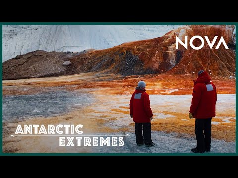
Antarctica is synonymous with white—until you reach Taylor Glacier.
Seeping from the glacier’s face into the McMurdo Dry Valleys is a deep red cascade known as Blood Falls. Against the frozen landscape, it looks like an open wound in the ice.
Discovered in 1911, the phenomenon puzzled scientists for decades. Early theories suggested red algae or unknown organisms. The truth proved both simpler and more astonishing.
Beneath Taylor Glacier lies a subglacial brine lake trapped for millions of years. This water, cut off from sunlight and air, became rich in dissolved iron. When fissures allow it to escape, the iron encounters oxygen for the first time in ages. It oxidizes—essentially rusting—and turns vivid red.
Even more remarkable, the brine hosts microbial life that survives without sunlight, relying instead on chemical reactions between iron and sulfur. These microorganisms endure extreme cold, high salinity, and total darkness—conditions once thought inhospitable to life.
Blood Falls is not blood. It is iron and time. Yet the sight of a glacier appearing to bleed remains deeply unsettling. Beneath Antarctica’s sterile surface lies a hidden ecosystem—and when it surfaces, it stains the snow crimson.[10]
More Great Lists
 Top 10 Impossible Things That Shouldn't Exist
 10 Words Grammar Snobs Say Shouldn't Exist but Do
 10 Reasons Antinatalists Think You Shouldn't Have Been Born
 10 Strange Physical Features You Didn't Know You Had
 Top 10 Musicals That Don't Actually Exist but Totally Should
 10 Fascinating Syndromes That Only Exist in Your Head
 10 Stories That Prove Good People Still Exist in the World
 10 Weirdest Pieces of Merchandise You Won't Believe Exist
 10 Really Strange Diseases You Won't Believe Exist
fact checked by
Darci Heikkinen
More Great Lists