
 Creepy
Creepy
Creepy  Animals
 10 Astonishing Animal Abilities Scientists Never Saw Coming
 Music
Music 10 Famous Musicians Who Grew to Resent Their Biggest Hits
 Animals
 10 Mass Animal Die-Offs That Looked Like the Apocalypse
 Weird Stuff
 10 Unexpected Objects People Have Treated as Sacred
 Movies and TV
 10 Tough-Guy Actors Who Unexpectedly Broke into Song
 Misconceptions
 10 Dinosaur Myths That Refuse to Go Extinct
 Weird Stuff
 10 Ridiculous Flat-Earth Arguments That Fail Simple Tests
 Technology
 10 Bizarre Places Electricity Is Hiding in Plain Sight
 History
 10 Nail-Biting Espionage Operations of the Cold War
Creepy 10 Drowned Towns That Reappear When the Water Recedes
Animals 10 Astonishing Animal Abilities Scientists Never Saw Coming
Music 10 Famous Musicians Who Grew to Resent Their Biggest Hits
Who's Behind Listverse?

Jamie Frater
Head Editor
Jamie founded Listverse due to an insatiable desire to share fascinating, obscure, and bizarre facts. He has been a guest speaker on numerous national radio and television stations and is a five time published author.
More About Us
Animals 10 Mass Animal Die-Offs That Looked Like the Apocalypse
Weird Stuff 10 Unexpected Objects People Have Treated as Sacred
Movies and TV 10 Tough-Guy Actors Who Unexpectedly Broke into Song
Misconceptions 10 Dinosaur Myths That Refuse to Go Extinct
Weird Stuff 10 Ridiculous Flat-Earth Arguments That Fail Simple Tests
Technology 10 Bizarre Places Electricity Is Hiding in Plain Sight
History 10 Nail-Biting Espionage Operations of the Cold War
10 Drowned Towns That Reappear When the Water Recedes
Somewhere beneath an ordinary-looking lake, streets lead to houses nobody has entered for decades. Across the world, communities were abandoned or forcibly emptied to make room for dams and reservoirs. Homes were demolished, churches were stripped of their bells, and entire populations relocated before the rising water erased what remained.
But these places did not disappear completely. During severe droughts, maintenance projects, or periods of unusually low water, their foundations, roads, churches, and bridges emerge from the mud. Some remain visible for months, while others vanish again almost as quickly as they returned. Here are ten drowned towns that refuse to remain hidden.
Related: 10 Fascinating Small Town Mysteries and Secrets
10 Vilarinho da Furna, Portugal
Vilarinho da Furna: A Aldeia Fantasma que Recusa Desaparecer! | Atlas Inusitado
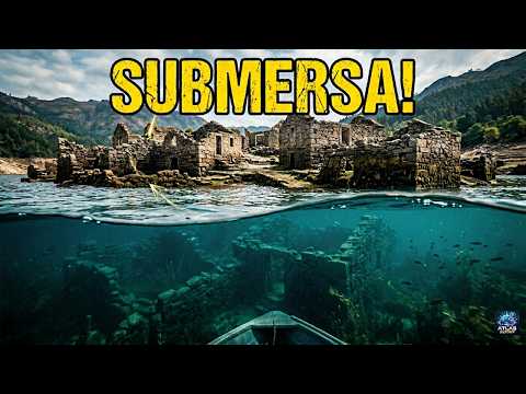
Vilarinho da Furna was a remote farming community in northern Portugal’s mountains. Nearly 300 people lived in its tightly packed stone houses, sharing fields, grazing land, and other resources through a distinctive communal system. Families had occupied the valley for generations, but the village’s location on the Homem River eventually put it in the path of a hydroelectric project.
Residents began leaving after the Portuguese Electricity Company acquired their property. The last inhabitants departed in 1971, taking everything they could carry—including roof tiles and other pieces of their homes. Once the reservoir filled, the village disappeared beneath the water.
It did not remain hidden. When drought or reservoir management lowers the water, Vilarinho’s walls, roads, and building foundations reappear. The stripped stone shells make it appear less like a place destroyed than one temporarily abandoned.
Former residents and their descendants also preserved what the reservoir could not. The Ethnographic Museum of Vilarinho da Furna opened in Campo do Gerês in 1989, incorporating material from the original village and displaying tools, clothing, and household objects rescued before the flooding. The water may conceal Vilarinho for much of the year, but its community was never entirely erased.[1]
9 Mediano, Spain
I found Spain’s Sunken Church
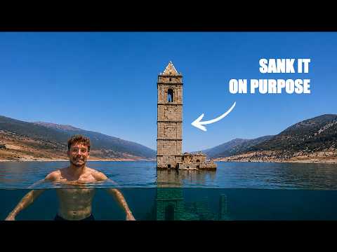
For years, the bell tower of Mediano’s Church of the Assumption looked like a stone buoy floating in a reservoir. It was the most visible reminder of the Aragonese village that once occupied the valley below.
Mediano was inundated in 1969, while the reservoir that gave it its name was still under construction. The rising water forced the remaining families from their homes and covered the village’s houses, streets, fields, and church. Although most of the settlement vanished, the church’s tall bell tower still protrudes when the reservoir is not completely full.
During severe droughts, the reservoir returns considerably more. Receding water exposes the church’s nave, cemetery, walls, roads, and portions of the former village. Visitors can sometimes walk across the cracked reservoir bed and enter ruins ordinarily accessible only to divers.
Decades of immersion have deteriorated the church, but its tower survives repeated cycles of flooding and exposure. When the reservoir is high, Mediano becomes a solitary spire. When the water falls, the tower becomes the marker for an entire settlement waiting underneath.[2]
8 Old Adaminaby, Australia
Why Australia Flooded an Entire Town in 1957

The original Adaminaby developed in the Snowy Mountains of New South Wales over more than a century. By the 1950s, it was an established rural town with houses, churches, stores, hotels, and a main street lined with Victorian-era buildings. Then Australia’s immense Snowy Mountains Hydroelectric Scheme placed it in the path of Lake Eucumbene.
Between 1956 and 1957, workers relocated 101 buildings, including 75 houses and two churches. Some were transported largely intact, while workers dismantled and reconstructed stone buildings piece by piece. Other structures were demolished or simply left behind. Residents were offered compensation, but many believed the relocation undervalued their property and fractured their community.
When Lake Eucumbene filled, most of the old townsite disappeared. Decades later, drought lowered the lake and exposed foundations, roads, abandoned machinery, vehicle remains, brickwork, and household objects. The reappearance drew visitors but also attracted souvenir hunters who removed artifacts from the site.
In 2008, New South Wales added Old Adaminaby and its surviving relics to the State Heritage Register. The designation recognized not only the engineering ambition of the Snowy Scheme but also the lives disrupted to create it. What returns during drought is therefore more than an underwater ghost town; it is a protected archaeological record of a community taken apart and rebuilt elsewhere.[3]
7 St. Thomas, Nevada
The Lost City of St Thomas Nevada Revealed! (Nevada Ghost Town)

Mormon settlers founded St. Thomas near Nevada’s Muddy River in 1865. The desert community eventually acquired a school, church, post office, grocery stores, garages, and a soda fountain. It also became a useful stop on the road between Los Angeles and Salt Lake City.
Its location became impossible after Congress authorized the construction of Hoover Dam. As Lake Mead began filling during the 1930s, residents dismantled buildings, removed possessions, and gradually abandoned the town. One of the last to leave was Hugh Lord, who reportedly paddled away in 1938 after the rising water reached his house.
At Lake Mead’s historic high point, St. Thomas lay approximately 60 feet (18 meters) underwater. Then the reservoir began falling. By the early 2000s, foundations and streets submerged for decades returned to the desert sun.
The exposed site is now accessible by trail within Lake Mead National Recreation Area. Visitors can follow the former street grid and see home foundations, schoolhouse steps, cisterns, tree stumps, and remnants of the town’s commercial buildings. St. Thomas has remained exposed during the reservoir’s prolonged decline, leaving a town once visited by divers standing on dry ground again.[4]
6 Sant Romà de Sau, Spain
Sunken Ghost Village Exposed by Drought!?! (Sant Roma de Sau)

For decades, the bell tower of Sant Romà de Sau served as an unofficial gauge of Catalonia’s water supply. When the Sau Reservoir was full, little or none of the tower could be seen. As the water dropped, progressively more of the 11th-century church emerged.
The old village was abandoned and inundated when the reservoir opened in the early 1960s. Its water became part of the system serving Barcelona and other communities in northeastern Spain. The church survived below the surface, but repeated immersion steadily weakened its stonework.
During Catalonia’s severe drought in early 2024, the reservoir fell to about 1% capacity. The familiar tower was no longer standing in water. The entire church and additional village ruins sat on dry, cracked earth, letting visitors walk through a landscape submerged for six decades.
Then the spectacle reversed. Heavy rain in March 2025 rapidly replenished the reservoir, covering the ruins once again. Sant Romà de Sau had resurfaced as a warning of an extreme water shortage and disappeared when the drought finally eased. Its tower continues to rise and fall with the reservoir, turning a medieval church into one of Catalonia’s most visible measures of changing weather.[5]
5 Curon Venosta, Italy
Curon: The Lost Village Beneath Lake Resia and The Mystery of Italy’s Flooded Bell Tower #italy #fyp

For decades, the bell tower rising from Lake Resia was almost all that remained visible of old Curon Venosta, also known as Graun im Vinschgau. Then, in 2021, the water was temporarily lowered, and parts of the village returned.
Approximately 900 people once lived in Curon’s 160 homes near Italy’s borders with Austria and Switzerland. In 1950, the valley was flooded to create a hydroelectric reservoir. Residents had protested the project, but their houses were demolished, their land was inundated, and the population was forced to relocate.
The village church was also destroyed, although its protected 14th-century bell tower was spared. It became a famous—and misleading—landmark. The tower suggested that an intact village remained below, when much of Curon had been reduced to foundations and rubble.
That changed in 2021, when leaks required the reservoir to be lowered for repairs. Stone steps, cellar walls, foundations, and pieces of the old streets emerged for the first time in decades. Residents and visitors could walk through remains normally hidden beneath the lake. Curon’s tower may appear permanent, but the resurfaced ruins revealed how much more of the village had been waiting underneath it.[6]
4 Tignes, France
Water Flows In Tignes (1952)

Before Tignes became an internationally famous ski destination, it was an Alpine farming village on the banks of the Isère River. Nearly 400 residents raised livestock and cultivated the steep land around them. After World War II, however, France’s demand for electricity placed the village in the path of the enormous Chevril Dam.
Residents protested, pursued legal action, and resisted the compulsory purchase of their property. Nevertheless, construction continued. They emptied buildings, relocated the cemetery, and demolished much of the old village—including its church—before the reservoir filled in 1952.
Unlike submerged settlements that return during droughts, old Tignes reappears when the reservoir is deliberately lowered for inspection or repairs. During a temporary draining in April 2024, the remains surfaced again. Foundations became visible across the lakebed, along with portions of the former road and the old bridge leading toward Val d’Isère.
The modern community of Tignes was rebuilt at a higher elevation, and its church was modeled on the one destroyed below. But when the reservoir recedes, residents can see the physical outline of the village their families lost. The exposed ruins are not intact houses rising dramatically from the water. They are subtler—and perhaps more affecting—traces of roads, walls, and foundations marking where an Alpine community once stood.[7]
3 Potosí, Venezuela
Decades after disappearing under water, the drowned town of Potosi re-emerges
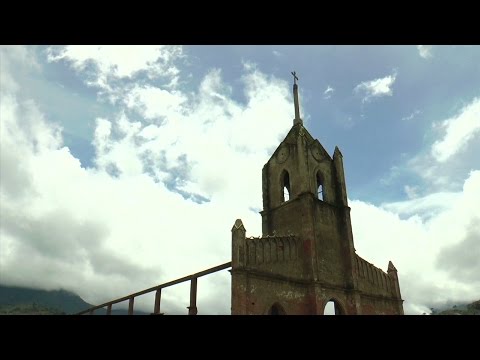
For years, the church spire protruding from Venezuela’s Uribante Reservoir served as a high-water marker. Beneath it lay Potosí, an Andean town of about 1,200 people that the government evacuated in the 1980s to build a hydroelectric project.
Residents reportedly learned their fate when President Carlos Andrés Pérez arrived by helicopter and announced the government would expropriate their property. Families dispersed across the country, while buildings were demolished or abandoned before the valley flooded. Once the reservoir filled, only the church spire remained above water.
Then a severe El Niño-related drought struck Venezuela in 2009 and 2010. The reservoir dropped approximately 98 feet (30 meters), contributing to electricity shortages and nationwide power rationing. It also left Potosí dry.
The church façade emerged first, followed by gravestones, house ruins, roads, and the outline of the old town square. Former residents came back to walk through the settlement they had been forced to leave more than two decades earlier. Some visited family graves, while others tried to identify where their homes had stood.
When rainfall returned, the reservoir began covering Potosí again. Its brief reappearance was therefore more than a tourist curiosity. It allowed a scattered community to revisit a hometown that had quite literally been removed from the map.[8]
2 Villa Epecuén, Argentina
El PUEBLO que quedó BAJO AGUA durante 20 AÑOS- Villa Epecuén – ARGENTINA

Villa Epecuén was built beside a highly saline lake in Argentina’s Buenos Aires Province in the 1920s. Promoted as a health resort, it grew into a prosperous vacation destination filled with hotels, bathhouses, restaurants, and entertainment venues. During its peak decades, as many as 25,000 tourists visited in a single summer.
Beginning around 1980, years of heavy rain steadily raised the lake. A protective embankment stood between the water and Villa Epecuén, but it failed in November 1985. Water entered gradually enough for approximately 1,500 residents to evacuate, yet it continued rising for years. At its highest point, the abandoned town lay beneath roughly 23 feet (7 meters) of water.
Around 2009, the lake finally began receding. What returned looked post-apocalyptic. Salt covered the buildings and dead trees in white mineral deposits. Walls had collapsed, vehicles rusted in the streets, and the remains of hotels stood roofless beneath the open sky.
Former resident Pablo Novak returned and became known as the town’s sole inhabitant, living near the ruins and recounting Villa Epecuén’s history to visitors. He remained its symbolic guardian until his death in January 2024. The town that once attracted tourists with its supposedly restorative water now draws them because that same water destroyed—and eerily preserved—it.[9]
1 Mologa, Russia
Russia’s ‘Atlantis’ Rises From Reservoir

Mologa was not a tiny village. It was a historic Russian town dating to at least the 12th century, with churches, schools, factories, and approximately 7,000 residents. Its location at the confluence of the Mologa and Volga Rivers once made it an important trading center. It also placed the town directly inside the planned Rybinsk Reservoir.
The Soviet government ordered the flooding in the 1930s to increase hydroelectric production and improve navigation. The Soviets evacuated and demolished Mologa as they created the reservoir in the 1940s. Approximately 130,000 people were displaced across the inundation zone, including Mologa and hundreds of surrounding settlements.
One frequently repeated story claims that nearly 300 people refused to leave and deliberately drowned with their homes. However, surviving residents disputed that account, pointing out that the water rose gradually and that the evacuation lasted for years. The documented displacement was devastating enough without turning an uncertain story into fact.
During unusually low-water years, Mologa returns in fragments. Former roads, foundations, gravestones, and building outlines emerge across the exposed reservoir bed. In 2014, the water fell far enough for former residents and their descendants to revisit portions of the townsite.
A museum in nearby Rybinsk preserves objects and photographs from Mologa, while memorial gatherings continue to honor the displaced community. The ruins do not reveal a perfectly preserved medieval town, but they expose something equally powerful: the street plan of a real place erased by government decree and briefly returned whenever the reservoir retreats.[10]
More Great Lists
 Ten Times Towns Were Wiped Off the Face of the Earth
 Top 10 American Ghost Towns That People Still Live In
 10 American Cities, Towns & Villages That Are Unlike…
 10 Christmas Towns Whose Name Has Nothing to Do with…
 10 Crazy Things That Happen When You Take Too Much…
 10 Ways People Reacted When They Thought the World…
 10 Dates When the Apocalypse Was Supposed to Happen
 10 Days of Humiliation When the Person Should Have…
 Ten Tiny Kansas Towns with Strange Claims to Fame
fact checked by Darci Heikkinen
More Great Lists