 Technology
  Technology
  Movies and TV
 10 Film Shoots That Almost Ended in Disaster
 Politics
 The 10 Most Bizarre Presidential Elections in Human History
 Weird Stuff
 10 Eggs-traordinarily Odd Eggs
 History
 10 Desperate Last Stands That Ended in Victory
 Animals
 Ten Times It Rained Animals (Yes, Animals)
 Mysteries
 10 Devastating Missing Child Cases That Remain Unsolved
 Creepy
 10 Scary Tales from the Middle Ages That’ll Keep You up at Night
 Humans
 10 One-of-a-kind People the World Said Goodbye to in July 2024
 Movies and TV
 10 Holiday Movies Released at Odd Times of the Year
 Technology
 Making 10 Common Products from Very Unusual Sources
 Movies and TV
 10 Film Shoots That Almost Ended in Disaster
 Politics
 The 10 Most Bizarre Presidential Elections in Human History
Who's Behind Listverse?

Jamie Frater
Head Editor
Jamie founded Listverse due to an insatiable desire to share fascinating, obscure, and bizarre facts. He has been a guest speaker on numerous national radio and television stations and is a five time published author.
More About Us Weird Stuff
 10 Eggs-traordinarily Odd Eggs
 History
 10 Desperate Last Stands That Ended in Victory
 Animals
 Ten Times It Rained Animals (Yes, Animals)
 Mysteries
 10 Devastating Missing Child Cases That Remain Unsolved
 Creepy
 10 Scary Tales from the Middle Ages That’ll Keep You up at Night
 Humans
 10 One-of-a-kind People the World Said Goodbye to in July 2024
 Movies and TV
 10 Holiday Movies Released at Odd Times of the Year
10 Unique Ruined Forts and Castles
Some of the most popular tourist destinations in world are ancient forts, castles, and battlefields. It is fun to imagine what it was like to live during a time when people fought with swords, cannons, muskets, and bows. In the Middle Ages, leaders constructed massive fortifications to protect their people. Forts and castles signified power, wealth, and military capability. Some of the greatest minds in the history of warfare designed fortresses to withstand any attack. They were placed in strategic locations and used to defend important routes. In the last century, the expansion of modern weaponry has diminished the need for fortified structures. Today, countries use other means to protect their borders. This article will examine the history of ten unique ruined forts and castles.

Biruaslum is a stack in the Barra Isles to the west of Vatersay, Scotland. A stack is a steep column of rock that is formed around sea coasts. Stacks can grow extremely high and Biruaslum reaches 72 meters (236 ft). Biruaslum is separated from Vatersay Island by a collection of steep cliffs on the eastern face. Sitting on the edge of the cliff is an ancient fort and well-constructed wall that is 2m wide and 3m high. The wall encloses a semi-circle and runs approximately 90 meters. The fortress is situated above a flat shelf and rocky gorge which separates it from Vatersay.
The ancient fort is most well preserved on the south-eastern end of Biruaslum. The structure extends away from the cliff and moves over the stack. The fortress holds the remains of a small oval stronghold which is located on the uphill side of the wall. The history of the fort remains unclear and historians are unsure who made it and for what purpose. The style of the structure appears to be from the Iron Age, but artifacts have been found from the Neolithic period. It has been determined that the Barra Isles have a long history. They have been featured in several Viking sagas and legends. It is difficult to visit the Biruaslum cliff fort, but charters to the islands can be organized by Barra Fishing Charters.

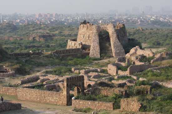
In 1321 AD, a man named Ghazi Malik assumed the title of Ghias-ud-din Tughlaq, and started the Tughlaq dynasty, which was a Turkic dynasty of Delhi, India. Upon taking control of the area, Malik became obsessed with building a massive fortification in the southern part of Delhi. He dreamed of a beautiful fortress that could keep away the Mongol marauders. In order to build the fort, Malik issued a dictate that forced all the laborers in Delhi to help construct it.
The massive fortification spans across 6.5 kilometers (4 miles) and includes three sections for housing, a citadel, and a royal residence. The grounds are littered with underground tunnels and the fort once held 52 gates (13 remain today). The walls surrounding the fortification are made of granite and between 10 and 15 meters (32-49 feet) high. The fort has a collection of massive stone buildings and tombs. Among the most famous is Mausoleum of Ghiyath al-Din Tughluq, which is an extravagant tomb that holds the remains of Ghazi Malik.
Legend says that Tughlaqabad Fort is cursed. In 1324, Ghazi Malik was crushed to death by a canopy. After his death, people became frightened by the land and the fortification fell into ruin. Ghazi Malik’s dream of a massive city in Delhi was lost and abandoned in 1327. Today, most of Tughlaqabad Fort is inaccessible due to the dense thorny vegetation and the potential for collapse, but sections of the area are still widely visited. The Bijai-Mandal is one of the most popular locations and is a large citadel that features the highest point. From the citadel, one can explore the vast tunnels and walkways underneath the fort.

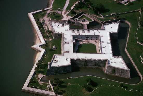
St. Augustine is a city in the northeast section of Florida that is the oldest continually occupied European-established city in the U.S. It was founded in 1565 by Spanish explorer and admiral Pedro Menéndez de Avilés and was a major hub along the “The First Coast,” which extends from Amelia Island to Jacksonville. After a series of attacks on the city, including a 1668 bombardment involving English pirate Robert Searle, the Spanish realized that they needed to protect the site, so they built a masonry fortification named Castillo de San Marcos. The structure is a star-shaped fort made of a stone called coquina. It is the oldest masonry fort in the United States.
Castillo de San Marcos has four bastions and a large ravelin that was used to protect the sally port. A ravelin is a triangular fortification that is placed outside the castle walls and used to sweep fire across attacking troops as they approached the curtain (wall). The fort was surrounded by a massive moat that used a series of floodgates. It had a glacis (artificial hill or slope) to help force attackers toward a series of cannon outposts. The fort also has a collection of infantry embrasures that were built in the walls so muskets could be fired from inside.
In 1702, the English decided to attack St. Augustine during Queen Anne’s War. All of the Spanish soldiers and residents in the area moved into Castillo de San Marcos to protect themselves. After a long bombardment, the English could not penetrate the walls of the fortress and were forced to retreat. The fort remained a stronghold in the area for centuries and has seen numerous battles. In 1763, the British captured Castillo de San Marcos and renamed it Fort St. Mark. In 1819, Spain signed the Adams-Onís Treaty, ceding Florida to the United States. Today, Castillo de San Marcos is a popular tourist attraction and occupies 2.5 acres (10,100 m²) in downtown St. Augustine.

The Battle of Stalingrad was a major event during World War II in which Nazi Germany attacked the Soviet Union for control of Stalingrad in southwestern Russia. The battle was marked by extreme brutality, disregard for military law, and massive casualties on both sides, nearly two million people died. At one point, the Third Reich captured 90% of the city, but the Soviets prevailed in the fight. During the battle, the Red Army attempted to occupy strategic positions throughout the city. One of these places was Pavlov’s House, which is a four-story building in the middle of Stalingrad and constructed parallel to the Volga River.
Pavlov’s House is located on a cross-street and provided a 1 kilometer line of sight to the north, south, and west of Stalingrad. In September 1942, the house was attacked and captured by the Germans. In response, the Red Army ordered a platoon led by Junior Sgt. Yakov Pavlov to take it back. After an intense battle where 26 of the 30 Soviets in the platoon were killed, the Red Army was able to capture Pavlov’s House. The house was then fortified and turned into a stronghold. The building was equipped with machine guns, anti-tank rifles, and mortars. It was surrounded by four layers of barbed wire, minefields, and the Soviets set up machine-gun posts in every available window. The supplies were brought into the fort through an underground communications trench.
During the battle, the Germans attacked Pavlov’s House several times a day. Each time the Red Army would unload a barrage of machine gun fire and kill dozens of Nazis. The Russians mounted a PTRS-41 anti-tank rifle on the roof of Pavlov’s House and destroyed a large number of tanks. The structure came to symbolize the Soviet resistance and was marked as a fortress on several Nazi maps. For his actions in the war, Yakov Pavlov was awarded the title Hero of the Soviet Union. Soviet general Vasily Chuikov famously said that the Germans lost more men trying to take Pavlov’s House than they did Paris. After the war, Pavlov’s House was reconstructed and turned into an apartment building. A memorial set of bricks from the battle remains at the site and is located on the East end of the house facing the Volga River.

During World War II, Hitler constructed a series of forts and Führer Headquarters across Europe. In 1941, upon the start of Operation Barbarossa, Hitler ordered the civil military engineering group Organisation Todt to build a large fortress in the Masurian woods, about 8 kilometers (5.0 mi) from the small East Prussian town of Rastenburg (now Kętrzyn, Poland). The fortress was used as a home for high ranking Nazi officials. In total, Hitler spent over 800 days at the Wolf’s Lair from June 23, 1941 to November 20, 1944. In order to ensure that the location was safe, the Third Reich went to great lengths. The buildings used heavy camouflage. They were hidden by bushes, grass, artificial trees, and netting.
The Wolf’s Lair was protected by Hitler’s personal bodyguard service, which used tanks, anti-aircraft guns, and other heavy weapons. Stations were constructed in order to detect aircraft from about 100 kilometers (62 mi) away. The fortress was constructed with a maze of tunnels and hidden rooms, guard houses, and over 54,000 landmines surrounded the installation. It was a large fortification and approximately 2,000 people lived and worked in the Wolf’s Lair at any given time.
On July 20, 1944, the Wolf’s Lair was the location of a well documented assassination attempt on Hitler’s life when Claus von Stauffenberg detonated a bomb in his vicinity. On January 25, 1945, the Wolf’s Lair was destroyed by the Nazis when Hitler ordered the fortress to be bombed. Tons of explosives were used in the effort, but the walls of the bunkers were so thick that many of the structures survived the impact and remain standing. Two days after it was bombed, the Red Army captured the site without a fight. The Wolf’s Lair was taken on the same day that Auschwitz was liberated. It has been estimated that about 180,000 people visit the ruins each year.

In 1534, a Polish military commander and politician named Mikołaj Sieniawski decided to build a massive fortress near Berezhany, western Ukraine. Sieniawski wanted to create a place that was impenetrable, so he selected a patch of marshy land that was located on a small island near the Złota Lipa River. The structure took twenty years to complete and was one of the best concealed fortresses of the 16th century. The Sieniawski family wanted to make the fort a stronghold, so they included an entry gate, quarter tower, church, protective bastion, and thick guarding walls (6 meters in places).
Large sections of the building’s design were hand carved, including the chapel ceiling and a series of sculptures. In 1630, Berezhany Castle was expanded to include a collection of military style installments, four towers, lodging, and another church. The fortress was reconstructed by famous Italian architects of the time. Amazingly, the structure was not damaged by the Khmelnitsky’s Cossacks or the Turks of the 17th century.
Berezhany Castle was used as a safe haven for royalty and rich. It was visited by a collection of famous people, including Peter the Great of Russia on two separate occasions. By 1908, the castle had fallen into disrepair. It underwent major damage in World War I and after the Soviet Union occupied Berezhany in 1939, the fortress was destroyed. Many reports say that the Red Army purposefully bombed the buildings. Since 1999, Berezhany Castle has been included on a list of places in Ukraine that need to be reconstructed.
![]()
One of the most important forts in the history of the United States is Ticonderoga. It is located near the south end of Lake Champlain and was constructed by Canadian and French forces between 1754 and 1757, during the Seven Years’ War. Ticonderoga was important because it is situated at the junction of a portage near the La Chute River. The fort looked over trade routes between the British-controlled Hudson River Valley and the French-controlled Saint Lawrence River Valley.
In 1758, 4,000 French soldiers were able to repel an attack by 16,000 British troops near the fort, but the British soon learned that they could control the location by securing high ground. During the American Revolutionary War, Ticonderoga was captured by a U.S. militia under the command of Ethan Allen and Benedict Arnold in a surprise attack. The fort was then recaptured by the British in June of 1777 and abandoned in 1781. Fort Ticonderoga is one of the most well preserved military forts in the U.S. It was restored in the early 20th century and now acts as a popular tourist destination and museum.
The town of Crown Point, New York is located in one of the most strategic areas of the United States. It is situated on the west shore of Lake Champlain and sits 39 miles (63 km) from Burlington, VT, 44 miles (71 km) from Queensbury, NY, and 108 miles (174 km) from Montreal, Quebec. In 1734, the French selected this area for a massive Fort Saint-Frédéric that was meant to control Lake Champlain and prevent British colonization. In 1759, the French left the fort before an advance of a large British army under General Jeffery Amherst. The British then constructed the much larger Fort Crown Point next to the ruins of Saint-Frédéric.
Fort Crown Point is the largest earthen fortress ever built in the United States. It was constructed with large walls, housing, and stations for cannons. After the Seven Years’ War ended, the British sent home many of their troops and left only a small number of soldiers at the fort. At the beginning of the American Revolution, Capt. Seth Warner and 100 Green Mountain Boys captured the fort in the battle of Crown Point. In total, the soldiers recovered 111 cannons and sent the weapons for use on the war front. Fort Crown Point was officially abandoned in 1780 and fell into ruin. In 1773, an accidental fire entirely destroyed parts of the fortress, leaving only the empty stone ruins of two barracks buildings. Today, the site is a popular tourist destination.

There are literally dozens of ruined castles in England, but I have chosen to include Corfe Castle. In 1066, William the Conqueror was able to invade and capture England. After his victory, William ordered the construction of a large number of castles across Europe, 36 in total. One of these fortifications was Corfe Castle, which was built by the Normans in order to control a gap in the Purbeck Hills that was used to travel between the English towns of Wareham and Swanage. The name “Corfe” is derived from the Saxon word for gap.
The castle is located next to a village named Corfe Castle in Dorset, England. Burial mounds in the area suggest that the land was occupied as long as 8,000 years ago. A large percentage of the castle was constructed under the order of William the Conqueror, but there was a stronghold at the site before the 11th century. In 978, Corfe Castle was the location of the murder of Edward the Martyr, King of England.
Corfe Castle is unique in that it was built on a massive hill overlooking the valley. Most medieval castles in England were constructed in valleys and near river crossings. The castle was organized in a triangular shape and has three wards. In the beginning of the 13th century King John ordered the creation of a fine hall, chapel, inner bailey, and domestic buildings at Corfe Castle. Henry III constructed additional walls, towers, and gatehouses.
In 1572, Corfe Castle was sold by Elizabeth I to Sir Christopher Hatton, who was her dance master and possible suitor. During the English Civil War (1642–1651) the castle was a stronghold for the Royalists (Cavaliers) and was besieged twice. In response, it was demolished on the order of the Parliament.
In 2006, workers restoring the castle discovered a hidden “appearance” door designed for Henry I in the stone. The find indicates that the castle was one of the most important in England during medieval times. Corfe Castle may have equaled the White Tower in prominence, which is a principal part of the Tower of London. In fact, Henry III ordered that Corfe’s keep be whitewashed in 1244. In 1240, he had the keep at the Tower of London whitewashed. The ruins of Corfe Castle are currently owned by the National Trust. The castle receives approximately 200,000 visitors each year.

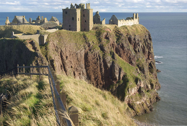
One of the most intriguing ruined castles in the world is Dunnottar. Dunnottar is situated on a rocky headland about two miles (3 km) south of Stonehaven, Scotland. The fortress overlooks ancient shipping lanes and was strategically situated to control land passage. For this reason, Dunnottar Castle has played a strategic role in the history of Scotland and been the site of many famous battles, including an important confrontation of the Dark Ages when Constantine II defied the conquest of Æthelstan, King of Wessex.
The ruins of Dunnottar are spread over 3 acres (1.2 ha). The only way to access the L plan castle is to pass over a narrow strip of land that has an extremely steep edge. The design of the fortress was strategically developed in order to prevent enemy soldiers from reaching the walls. In order to capture the castle, armies needed to use heavy artillery. During its long history, Dunnottar was visited by some of the world’s most famous leaders including William Wallace, Mary Queen of Scots, and King Charles II. In the 17th century, a small garrison of soldiers famously held off the army of Oliver Cromwell for eight months and saved the Scottish Crown Jewels from theft.
After Cromwell was able to get his cannons up the steep cliffs surrounding the North Sea, he bombarded the castle and captured the remaining soldiers. The land has never recovered from the massive attack and has remained in ruins for centuries. The last time Dunnottar was used for active duty was 1715 when Earl Marischal was executed for his part in the Jacobite Rising. The fortress has become a popular tourist destination and is open to visitors on a daily basis. Certain sections of Dunnottar Castle were once used as a dungeon and are said to be haunted. If you visit the site late at night, you might hear cries from the rocks below the massive cliffs.

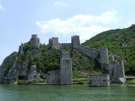
Golubac Fortress is a medieval fortified town that is located 4 kilometers downstream of the modern-day village of Golubac, Serbia. The compound was built in the 14th century to protect an important stretch of the Danube River. It sits at the head of the Iron Gate gorge and was used to control river traffic. In medieval times, a strong chain was placed across the river that connected to a large rock named Babakaj. If a ship wanted to pass, they needed to pay a tax.
Golubac Fortress was the last military outpost located on the Danube River and the final line of defense between Hungary and the Ottoman Empire. For this reason, the fort witnessed dozens of large scale military conflicts, both cold steel and firearm based. The fortification was a key advantage in the world of conquest and warfare. It regularly shifted hands between the Turks, Hungarians, Serbs, and Austrians until 1867, when it was turned over to the Serbian Knez, Mihailo Obrenović III.
Golubac Fortress is split into three compounds and shows signs of heavy reinforcements over the centuries. It has ten towers, two portcullises, and a collection of military outposts. Each tower had a specific purpose, including a citadel, chapel, dungeon, and weapon storage facilities. The fortress used a large moat, which trapped water from the Danube and made it difficult to reach the land. From 1964-72, a dam was built inside the Iron Gate gorge which elevated the river’s water and flooded sections of the fort. Today, Golubac Fortress has become a popular tourist destination. It is one of the most important sightseeing points on Danube boat tours.


