 Politics
  Politics
  Weird Stuff
 10 Eggs-traordinarily Odd Eggs
 History
 10 Desperate Last Stands That Ended in Victory
 Animals
 Ten Times It Rained Animals (Yes, Animals)
 Mysteries
 10 Devastating Missing Child Cases That Remain Unsolved
 Creepy
 10 Scary Tales from the Middle Ages That’ll Keep You up at Night
 Humans
 10 One-of-a-kind People the World Said Goodbye to in July 2024
 Movies and TV
 10 Holiday Movies Released at Odd Times of the Year
 Politics
 10 Countries Where Religion and Politics Are Inseparable
 Weird Stuff
 10 Freaky Times When Famous Body Parts Were Stolen
 Politics
 The 10 Most Bizarre Presidential Elections in Human History
 Weird Stuff
 10 Eggs-traordinarily Odd Eggs
 History
 10 Desperate Last Stands That Ended in Victory
Who's Behind Listverse?

Jamie Frater
Head Editor
Jamie founded Listverse due to an insatiable desire to share fascinating, obscure, and bizarre facts. He has been a guest speaker on numerous national radio and television stations and is a five time published author.
More About Us Animals
 Ten Times It Rained Animals (Yes, Animals)
 Mysteries
 10 Devastating Missing Child Cases That Remain Unsolved
 Creepy
 10 Scary Tales from the Middle Ages That’ll Keep You up at Night
 Humans
 10 One-of-a-kind People the World Said Goodbye to in July 2024
 Movies and TV
 10 Holiday Movies Released at Odd Times of the Year
 Politics
 10 Countries Where Religion and Politics Are Inseparable
 Weird Stuff
 10 Freaky Times When Famous Body Parts Were Stolen
10 Places Abandoned After Disasters
In the wake of massive disasters, it isn’t uncommon for entire communities to abandon affected areas and never return. This is done for a variety of reasons: the damage and destruction might be too severe for rebuilding work to ever take place; there might be a chance that the disaster could occur again at a later date; or, simply, the loss of life that occurred might be too heartbreaking.
Indeed, you might have heard about the abandonment of places like Chernobyl and Centralia from previous articles. So, here are ten examples of this phenomenon which you might not have heard about:
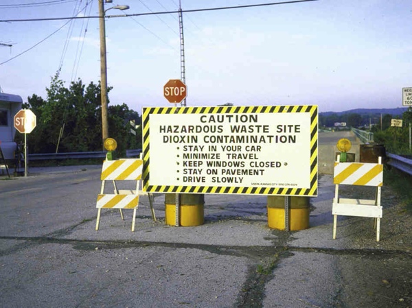
In the early 1970s, the town of Times Beach in Missouri was plagued with a problem: as most of its roads were unpaved, cars and pedestrians would kick up quantities of dust, causing a massive safety issue for anyone traveling along them. So in order to prevent this, the town hired a waste hauler called Russell Bliss to oil the roads, a role he carried out between 1972 and 1976.
At the same time, however, Bliss was also contracted by another company, ICP, to dispose of toxic waste produced by Northeastern Pharmaceutical and Chemical Company (NEPACCO). During the Vietnam War, NEPACCO was one of the government’s suppliers of the infamous Agent Orange, a defoliant which contained the dioxin, TCDD. Like all dioxins, TCDD can cause immune and reproductive disorders, alongside other conditions such as cancer and chloracne (a severe acne-like condition which can last for decades).
Unbeknownst to everyone, Bliss had been oiling the roads of Times Beach with a mixture containing used engine oil and the NEPACCO waste. On December 3, 1982, the Environmental Protection Agency (EPA) took samples of the town’s soil. The result? It was contaminated with levels of dioxin one hundred times higher than the level considered hazardous to human health. Unfortunately, before any action could be taken, the nearby Meramec River overflowed on December 5 and flooded the town, spreading the contaminant throughout the whole city.
Eventually, the floodwaters receded and in 1983, the EPA evicted the town’s population and reclaimed the land—a buyout which cost a reported $32 million. By 1985, the town had been bulldozed and all the soil incinerated in specially-built mobile furnaces. Today, the area on which the town stood is now a state park. As for the dioxins, the EPA revisited the site in 2012 and tested the soil again, eventually concluding that there was no longer any health risk associated with the site.
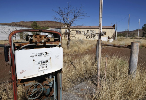
The town of Wittenoom in Western Australia was originally established in 1947 to provide accommodation for workers at the nearby crocidolite mine. But as time went on, the town grew in size. In 1951, it had a population of five hundred, and prior to its abandonment in 1966, it was home to over twenty thousand people.
Dirt extracted from the mines was used to create sandpits for the children of the town to play in, as well as greens for the town’s gold course and a “beach” next to the town’s pool. The dirt was also used to line the streets, playgrounds and footpaths of the town. Sadly, however, no resident realized the danger of what they were doing. Crocidolite is known today as “blue asbestos.” Although all types of asbestos are hazardous to human health, blue asbestos is perhaps the most dangerous, as its fibers are likely to cause malignant mesothelioma (a rare form of cancer which develops inside the linings of organs such as the lungs and heart) in people who inhale it.
Throughout much of the time that the mine was operating, concerns were constantly raised by health specialists about the effects of the asbestos on the townspeople. But these were ignored by the mine’s owners. The mine finally closed in 1966 and, at nearly the same time, several air surveys revealed that asbestos particles were present in every building of the town. Action was finally taken in 1979 when the government began winding down Wittenoom by offering to buy residents’ houses and pay for their relocation costs. Many took this offer, and left their homes to be demolished. But a small number defied this situation, and were still resident in the town as of 2006—despite the official removal of the town’s status, its removal from all road signs, and its disconnection from the country’s main electric grid.
A conservative estimate of the casualties suggests that of the twenty thousand who lived in Wittenoom, over two thousand have since died from asbestos-related illnesses. As well as this, Western Australia suffers from one of the highest rates per capita of malignant mesothelioma in the world.
 Deception Island is located seventy-five miles north of Antarctica, inside the cluster of islands known as the South Shetland Islands. It was first founded in the early nineteenth century by a British naval expedition, and it played host to a thriving early-twentieth century industry of whaling. By 1914, there were fourteen whale blubber processing plants on the island, owned by a variety of nations, including Chile and Norway. But after the Great Depression caused the whaling plants to become unprofitable, they were eventually abandoned.
The British established a permanent scientific base on the islands in 1944, and Chile did the same ten years later. But volcanic eruptions on the island in 1967, 1968, and 1969 forced the British to abandon the island entirely, leaving behind derelict fueling stations and huts. Although they somehow survived the eruptions of 1967 and 1968, the 1969 eruption also caused the destruction of two Chilean bases, a loss which led their scientists to abandon the island as well.
The island currently has no permanent residents—but like Chernobyl, it plays host to a thriving tourist trade. The variety of industries that once occupied the island have left behind a wealth of ruined buildings and equipment for tourists to explore, including fueling stations and pumps, huts, scientific research stations, and an aircraft hangar.
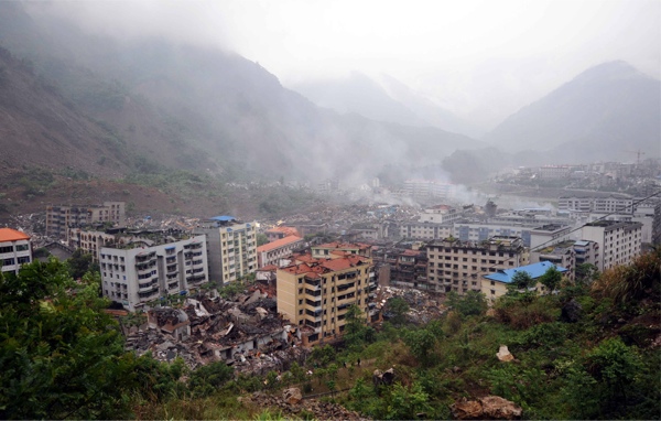
On May 12, 2008, an earthquake with a magnitude of 8.0 hit the Sichuan province of China, killing more than 69,000 people and injuring another 374,000. It also left between five and eleven million people homeless—a high proportion of the fifteen million people that lived in the affected area.
One of the worst-hit towns was the town of Beichuan, in the north of the province. Of all the buildings that stood there, over eighty percent collapsed during the quake.
Thoughtfully, the government elected not to demolish the ruins of Beichuan, and instead decided to preserve the town as a museum. Collapsed buildings were supported with specially-installed hydraulics to prevent their further collapse, effectively freezing the site in the state caused by the earthquake.
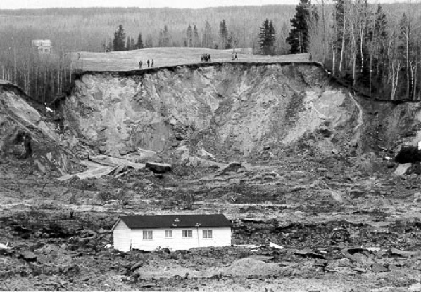
Unusually, there is little information about the disaster that devastated the tiny village of Saint-Jean-Vianney in Québec on May 4, 1971. What is known tells us that following a period of extremely heavy rain, the notoriously unstable Leda Clay—upon which the town had been built—liquefied and collapsed. This created a thiry-meter high abyss, which consumed as many as forty houses.
Prior to this cataclysm, the townspeople reported a number of strange occurrences: the foundations of several houses sank six to eight inches into the soil, large cracks appeared in streets and driveways, and people reported hearing heavy thumping noises (as well as the sound of running water) coming from underground. Nevertheless, in the five minutes that it took for this landslide to occur, thirty-one people were killed—a figure which would have been much higher if it had happened later at night. Unsurprisingly, the village was later abandoned by the remaining residents, who were rehoused in the nearby city of Arvida.
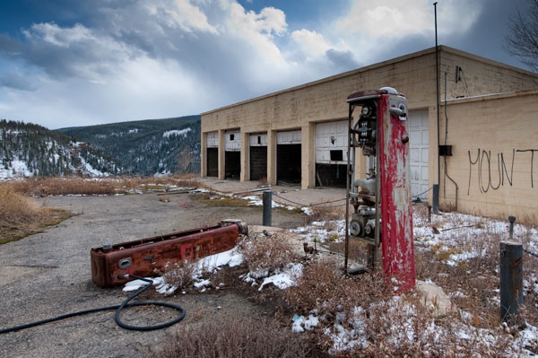
The town of Gilman, in Colorado, was home to Eagle Mine, one of the most important mines in the state. It held massive reserves of zinc and lead, and could contain several hundred workers. Opened in 1886, its miners were rendered exempt from the military draft of WWII because the zinc they were mining was vital to the country’s war effort. Following the end of this war, however, the mine ran into financial problems as demand dried up, and in 1977 the mine was closed.
After closure, the mine’s dewatering pumps—which prevented the lead and zinc from washing into the groundwater—were turned off. As the result, the deepest levels of the mine were flooded and the chemicals were washed into the nearby Eagle River, a main source of drinking water for the townspeople.
In response, the EPA took control of the mines and the town, declared the entire area to be a Superfund site, and evicted everybody living there. Work to decontaminate the site was carried out, but the town is still closed today.
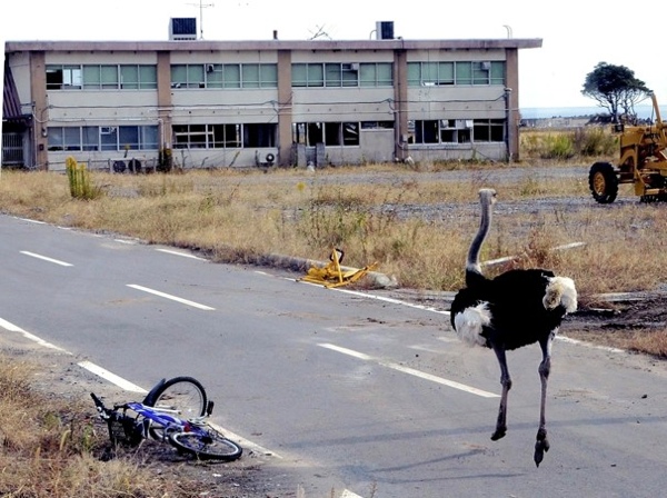
Following the meltdown at the Fukushima Nuclear Power Plant after the 2011 Japanese Tsunami, a 30km exclusion zone was established around the facility, in order to safeguard people from being exposed to any potential fallout from the reactor. Tomioka was one of several towns, villages, and cities to be evacuated (in total, 488,000 people were rushed out of the area in the two weeks following the disaster). Before the disaster, Tomioka had a population of approximately 16,000 people, the vast majority of whom were evacuated. For this reason, much of the damage caused by the tsunami (which hit the coastal area of the town) has still not been repaired.
Only one man still resides in the city, and he has tasked himself with feeding the animals that were abandoned by their owners during the evacuation. Alongside dogs and cats, these include cattle, pigs, and boar which escaped captivity and now live in the wild.
As of writing, there’s no indication that the exclusion zone will ever be lifted or that the townspeople will ever be allowed back inside.

The outbreak of World War Two led to a number of areas of the British countryside being seized in order to provide space for military bases and training areas. One example of this is the tiny village of Tyneham in Dorset, which was seized in 1943 along with the surrounding 7500 acres of woodland and heathland. This resulted in the immediate eviction of 252 people. Reportedly, the last person to leave left the following note nailed to the door of the church (which is still preserved there today):
“Please treat the church and houses with care; we have given up our homes where many of us lived for generations to help win the war to keep men free. We shall return one day and thank you for treating the village kindly.”
It seems unlikely that the villagers (or, at least, their descendants) will ever be allowed to return. As the author discovered when he visited the site several years ago, the surrounding countryside is littered with signs warning of hazards including unexploded shells and fast-moving armored tanks from the nearby Armored Fighting Vehicles Gunnery School. Regardless, visitors are sometimes allowed into the village, which contains a medieval-era church, a renovated manor house, and a vast array of wildlife (which has thrived as a result of the relative abandonment of this area).
On February 20, 1943, two farmers were burning shrubbery in their cornfield, when suddenly a patch of land in front of them began to swell. While they watched in amazement, the ground split open, forming a smoking, two-meter-deep fissure which smelt strongly of rotting eggs. Within a single day of this fissure’s appearance, a fifty-meter-tall cone of rock had erupted from the ground. Within a week, the cone was one hundred meters tall and spewing out thick clouds of smoke and ash, which began to fall on the adjacent villages of San Juan Parangaricutiro and Paricutin.
On June 12, the new volcano (now with a height of 424 meters) finally erupted; fortunately for Paricutin, however, the flow of lava that emerged was so slow that the entire village was successfully evacuated by the end of the next day. Several months later, San Juan Parangaricutiro was also evacuated in the same manner, before lava could engulf the village. Miraculously, no-one was killed directly by the volcano; the only deaths occurred when three people were struck by lightning, which was caused by atmospheric disturbances triggered by the volcano.
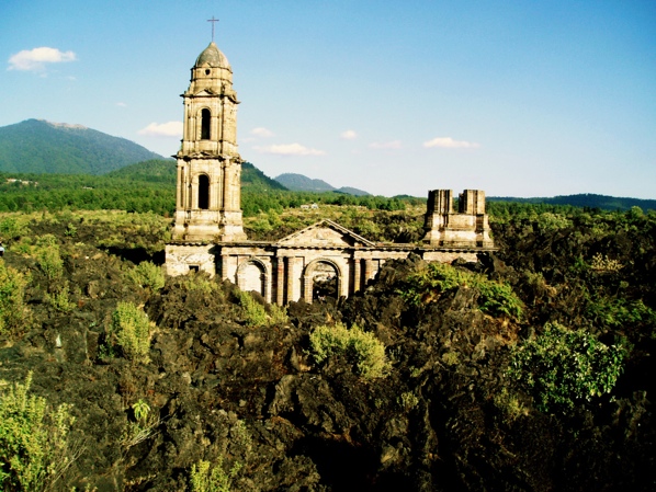
By the end of 1944, both villages had been buried under a tide of lava and ash, with the only visible reminder that they once existed being the church tower of San Juan Parangaricutiro which now sticks out of the cooled lava. The slow eruption of Paricutin volcano continued for another nine years, before eventually coming to a halt in 1952.
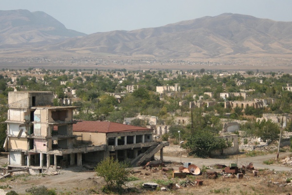
In July 1993, following an intense period of fighting, forces belonging to the Nagomo Karabakh Republic captured the city of Agdam, located within south-western Azerbaijan. This republic, which was supported by neighboring Armenia, had been formed only one year earlier, following the secession of several areas from Azerbaijani control. The attacks were therefore intended to expand the territories held by the Nagomo Karabakh.
On July 4, an artillery strike from Armenian forces led to the mass evacuation of Agdam by its citizens. By the end of July, the entire town was under the control of the Nagomo Karabakh Republic who, according to reports, committed several violations of the rules of war (including the forcible displacement of citizens and hostage-taking). Eventually, fearing a counterattack by Azerbaijani forces, the Nagomo Karabakh ordered the town to be destroyed, in order to prevent its recapture.
Today, the ruins of Agdam serve as a buffer zone between Azerbaijan and the Nagomo Karabakh Republic, meaning that its permanent reoccupation is near-impossible.
For more from Adam, you can check out his website or follow him on Twitter.


![10 Abandoned Amusement Parks With Horrific Histories [Disturbing] 10 Abandoned Amusement Parks With Horrific Histories [Disturbing]](https://listverse.com/wp-content/uploads/2019/09/gulliver-150x150.jpeg)
