 Weird Stuff
Weird Stuff
Weird Stuff  Mysteries
 10 Tragic Disappearances and Deaths in Joshua Tree National Park
 History
 10 Ways Childhood Really Sucked in the Old West
 Music
Music 10 Name Origins of Famous Bands from the 1990s
 Religion
 10 Biggest Turnarounds by the Catholic Church
 Weird Stuff
 10 Unbelievable Times Laws Had Unintended Consequences
 Humans
 Ten Historic Women Who Deserve Way More Credit Than They Got
 Movies and TV
 10 Films That Spawned Major Lawsuits
 History
 Ten Times Towns Were Wiped Off the Face of the Earth
 Creepy
 10 of the Most Disturbingly Haunted Public Houses in the UK
Weird Stuff 10 Niche Subcultures That Are More Popular Than You Might Think
Mysteries 10 Tragic Disappearances and Deaths in Joshua Tree National Park
History 10 Ways Childhood Really Sucked in the Old West
Who's Behind Listverse?

Jamie Frater
Head Editor
Jamie founded Listverse due to an insatiable desire to share fascinating, obscure, and bizarre facts. He has been a guest speaker on numerous national radio and television stations and is a five time published author.
More About Us
Music 10 Name Origins of Famous Bands from the 1990s
Religion 10 Biggest Turnarounds by the Catholic Church
Weird Stuff 10 Unbelievable Times Laws Had Unintended Consequences
Humans Ten Historic Women Who Deserve Way More Credit Than They Got
Movies and TV 10 Films That Spawned Major Lawsuits
History Ten Times Towns Were Wiped Off the Face of the Earth
Creepy 10 of the Most Disturbingly Haunted Public Houses in the UK
10 Natural Disasters That Created A More Beautiful World
Yellowstone National Park ranks as the #1 best national park in America. Santorini, Greece, is a bucket list destination, honeymoon location, and dream vacation spot. The African Safari has more to see than we can ever see in one trip. Yet, these locations have more in common than their uncommon beauty. The history of their formation ranges from unexpected to tragic, and every single one can attribute their creation to a well known natural disaster.
SEE ALSO: 10 Strange Beauty Secrets Of History’s Most Beautiful Women
10Yucatan Cenotes and the Chicxulub Asteroid
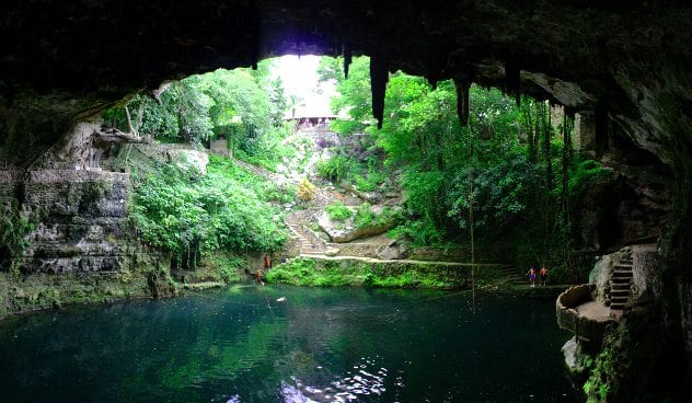
The many cenotes (sinkholes) that pepper the Yucatan peninsula in Mexico are unique. Their turquoise waters rest beneath sky lit caves. Lush plants grow along their high walls, opening to azure skies. Yet, the true magic happens in the water beneath the limestone sinkholes.
The cenotes of the Yucatan Peninsula are meromix aquifers. This means that 10 meters (33 feet) below the top layer of clean groundwater is another layer of salt water. The two layers do not mix, and through most of the year, they remain crystal clear. The cenotes were a source of fresh water for the Mayans in dry times. They also played an important role in Mayan spirituality. A cenote called Chichen Itza has revealed many artifacts sacrificed to the well. Seeing one of these cenotes leaves little mystery about why the Mayans would worship in such a place.
It is easy to concentrate on the relaxation you could enjoy in such a beautiful location. Yet, the cenotes of Yucatan show us more than a glimpse into the lives of the Mayans who lived near them. They outline the impact crater of Asteroid Chicxulub. This is the asteroid that we give credit for the mass extinction at the end of the Cretaceous period. Along the edges of the impact crater, is the ring of Yucatan cenotes. This ring gives us an idea of how large the asteroid might have been when it hit; 240 kilometers (149 miles) across.
9Niagara Falls and the Ice Age

The Niagara Escarpment is well known for the vast amounts of water that flow over it. In New York and Ontario Canada, the Niagara River plummets up to 34 meters (110 feet) to the pools below. More than 170,000 cubic meters (six million cubic feet) of water pour over the crest line of the falls every minute. The powerful falls provide a breathtaking backdrop for vacations and destination weddings alike.
The creation of Niagara Falls took much longer than an asteroid hitting the planet. The Pleistocene, which formed this site and many others, was a long-lasting natural phenomenon. Most people know the Pleistocene by its more common moniker, The Great Ice Age. This is when much of the world’s megafauna, including the mastodons and the wooly mammoth, went extinct.
Along with the extinction, there were massive changes to the world’s landscape. One of the extensive changes was the formation of the Niagara Falls. The water that supplies the falls came from the last northward retreat of the glaciers, which covered Southern Ontario with ice sheets two-three kilometers thick. That is almost two miles of ice.
8Crater Lake
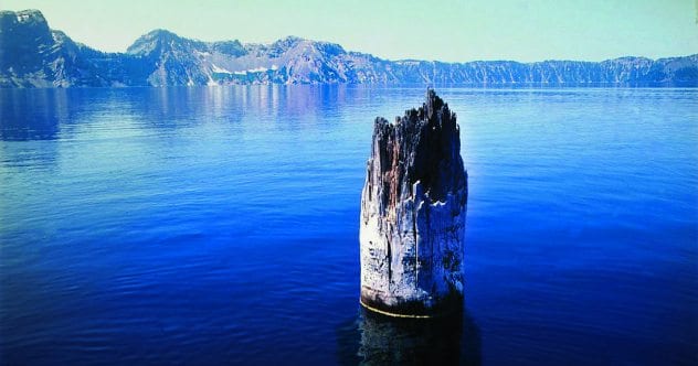
In the Southwestern forests of Oregon is the beautiful Crater Lake. Pristine blue waters, lush green pines, and the wistful magic of Pumice Castle and Wizard’s Island. There is something about Crater Lake that draws you in. It begs you to spend a few nights camping in the Crater Lake National Forest. If you are lucky, you might even spot The Old Man of the Lake. The Old Man is an ancient hemlock that has managed to float upright for over a 100 years. Beneath the sun bleached, well-traveled log is a crater that, at its deepest point, is 592 meters (1,943 feet). The combination of beauty and mystery that Crater Lake provides is one that you will not want to miss.
There is no mystery in the creation of the lake itself. The top of the ancient volcano sunk during its eruption. The caldera took 250 years of rainwater to fill. Approximately 7,700 years ago the volcano, named Mt. Mazama, was over 3,600 meters (12,000 feet) tall. The eruption blasted 20 kilometers (12 miles) high, and a cloud of ash and lava fragments, called pyroclasts, carried as far as central Canada. There are ash particles from the explosion as far away as Greenland.
7Yellowstone National Park
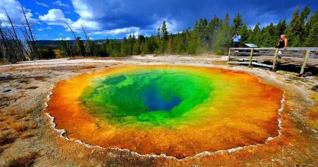
Almost thirteen hundred kilometers (800 miles) away from Crater Lake is Yellowstone National Park. The park is a unique combination of flora, fauna, and fountains that shoot steaming water into the sky. Yellowstone is well known for the geyser “Old Faithful,” whose regular blasts can reach up to 56 meters (185 feet). Other rare sights include the Yellowstone Sand Verbena and Yellowstone Sulfur Wild Buckwheat. They are endemic to the area, meaning they are only found in the park. It is not uncommon to see bison, moose, wolves, and bears after spending only a few hours inside the beautiful landscape.
However, there is a dangerous history to Yellowstone. Many people know about the potential of the Yellowstone supervolcano erupting in our future. What few know about are the three major explosions that overtook the land before it became a national park.
Dating back 2.1 million years, the park was home to three massive eruptions. The strength of these explosions reached up to 6,000 times the strength of the 1980 Mt. St. Helens eruption. The resulting calderas, plants, and animals are what now makes up most of the park today.
6Ngorongoro Crater
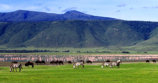
The location of the Ngorongoro Crater is near the more well-known Serengeti plains. It is the world’s sixth largest unbroken caldera. In the crater, you can find elephants, zebra, and black rhino. Cheetahs and lions also roam the crater, along with 500 documented species of birds. The vegetation ranges from bamboo to short grass and native trees. There are even rainforests near the rim. The wildlife and vegetation are not the only things you might see when visiting the crater, though.
The native Maasai people and their livestock live in harmony with the local wildlife. The nearby crater of Olmoti offers stunning waterfalls. Empakai, another crater in the park, holds a deep lake and lush, green walls. There is no end to the sights that the Ngorongoro Conservation Area offers us today.
Three million years ago the Ngorongoro crater was a massive volcano that towered over the land. The volcano’s height ranged between 4,500 to 5,800 meters (14,800 to 19,000 feet) high, nearly as high as the nearby Kilimanjaro stands today.
The caldera has a depth of 610 meters (200 feet) and a base area covering 260 square kilometers (100 square miles). This three-million-year-old volcanic eruption would have been a massive natural disaster, sure to have destroyed everything in its path. Today the result is a location of incredible beauty.
5Okavango Delta
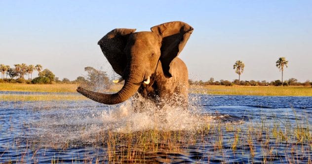
When you think of the Kalahari Desert, you might think of orange sands and a blistering sun. Yet, at the base of the Okavango River, we can find an inland delta. The Okavango Delta is a unique World Heritage site that does not empty into the ocean like most deltas do. Instead, it has transformed the Kalahari into a permanent marshland.
Crystal blue waters and a vast ecosystem of plant and animal life thrive there. African Elephants, Zebras, Hippo, and several other large animals populate the delta. The annual flood-tide from Angola brings, even more, life to the otherwise arid desert backdrop. A safari adventure to Okavango Delta is not one we should miss.
We could have missed it, though, if it were not for the earthquake that caused the East African Rift Valley. The Okavango river once did as all rivers do; it flowed down towards the ocean through large lakes. Then the newly named Nubian and Somalian plates began to form. As a result, the rifts and earthquakes interrupted the flow of the river, and it spilled out onto the desert to form the lush landscape.
4Undara Lava Tubes
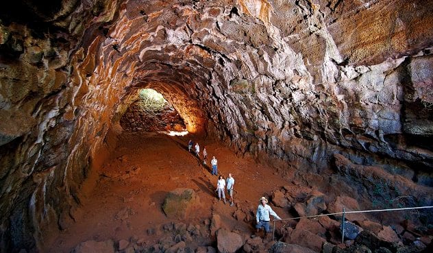
If you are planning to go to Australia, the Great Barrier Reef might come to mind. The cities of Sydney and Brisbane could also be your ultimate destination. Yet, a short 3.5-hour drive from Cairns will take you to a system of lava tubes you will not want to miss. Undara is an Aboriginal word that means “the long way,” an apt name for one of the longest lava tubes on the planet.
The tubes extend for approximately 32 kilometers (20 miles). That is a long hike, but it is worth the time. The tubes contain some of the most biologically diverse caves in the world. The collapsed roofs in the caves allow sunlight to reach the plants and animals living there. This includes four species of bat and the common wallaroo. Thickets of semi-evergreen vine grow in the cave as well. The origin of the vines traces back to the separation of the ancient supercontinent of Gondwanaland. Those are some old vines.
The creation of a lava tube is an inherent natural disaster—a massive volcanic eruption producing 23.3 cubic kilometers (5.6 cubic miles) of lava. The flow moved at a rate of about 1000 cubic meters (35.300 cubic feet) every second and traveled over 160 kilometers (100 miles), consuming everything in its path. The Undara Lava Tubes formed when the lava gushed into a dry riverbed, and the top layer solidified. The lava inside the tube carried on for many kilometers before draining out. What it left behind was the shell of the tubes we see today.
3Ujung Kulon—Krakatoa
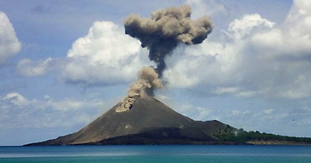
As far as rare sights go, the Javan Rhinoceros is one of the rarest. With only 60 rhinos left, they are an endangered species that is only found in the Ujung Kulon National Park. There are also 57 rare plants that grow in the Indonesian park. As a World Heritage Site, the park is a breathtaking journey of soft sand beaches and snorkeling. Tropical mountains and several islands may also catch the eye.
The main feature of Ujung Kulon is the now dormant volcano Krakatoa. Krakatoa is well known for its violent explosion in 1883. The explosion killed 36,000 people, and the sound it made during its explosion reached as far as 4,800 kilometers (3,000 miles) away. This was the loudest sound ever recorded on the planet. The resulting ash cloud blocked the sun for several days in the area. The loss of lives and damage to nearby islands resulted from the natural disaster. The lush green rainforests and pristine natural ecosystem were also a result. The national park that now lays at the volcano’s base is a clear show of the resilience of the planet.
2Mediterranean Messinian Salinity Crisis
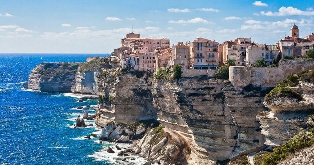
Turquoise seas, warm winters, and sun shining summers. White sand beaches and whitewashed walls. Cities built on rocky cliffs overlooking the ocean. This imagery is the quintessential vacation. This is the place you dream of when you talk about your hopes to travel the world and see the sites. This is the Mediterranean. The cultures that thrive on the islands here have brought us a unique cuisine and history. Rome, Greece, Sicily, and Carthage all fought for control of it over the years. The 3,900-kilometer (2,400-mile) long sea played an important role in their rises and falls in power. It also allowed trade between the Europe and Asia.
Yet, the cultures and civilizations we have today were once at risk of never existing. The beautiful islands, coastlines, and calderas might never have happened. If it were not for the Zanclean Flood, the Mediterranean could still be the desert basin it was 5.6 million years ago.
Blocked from its ocean sources, four kilometers (2.5 miles) of water vanished from the Mediterranean. For perhaps 800,000 years the Mediterranean remained mostly dry. Then about 5.33 million years ago there was a rapid refill of the sea. The same Gibraltar straits that had blocked the ocean opened again. An estimated 90 percent of the basin filled within a two year period, filling at a rate of up to ten meters per day. The islands we have now, the land of dream vacations, returned, due to a massive flood.
1Galveston Hurricane, 1900
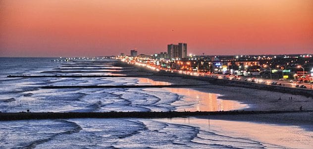
Over fifty kilometers (32 miles) of shoreline and activities for every kind of person, the Island of Galveston, Texas, is one that offers a no-fuss vacation. Only 50 minutes from Houston, this island is one that you can get to by car. There is plenty of shopping, attractions, and cruising to keep you occupied. Beaches, dolphin swims, and horseback riding will draw you to the natural side of this island city.
Galveston was not always the sunny, happy town it is today. It is well known for being the location that Hurricane Galveston made land in 1900. A category four storm with winds up to 225 km/h (140 mph) tore over the island. The death toll reached over 6,000 of the 37,000 citizens and over 3,500 buildings and homes vanished.
Some call it the worst Natural Disaster in US history. The one thing that is certain is that this hurricane was a tragedy. Yet, today you can still go to Galveston, you can sit on the beach and stare out at a much calmer sea. You can hear the laughter of local children and see the beautiful city that stands proud today.
These natural disasters have torn the land apart. They have blasted holes into the earth and taken more lives than we can count. Yet, the earth, the animals, and the people who live on it are resilient. Whenever tragedy strikes, we will recover and repair. The destruction will fade, making way for a more beautiful world.
A speculative fiction and freelance writer, Jessica Betts spends most of her day staring at the keyboard wondering how her odd knowledge of local myths can be incorporated into both her articles and her novels. Jessica can be found on social media under BettsICan, and at her website. Her upcoming Novel, Second Nature, is planned for publishing just as soon as she can convince herself it’s ready.
More Great Lists
") 10 Heartwarming Stories Of Pets Who Survived Natural…
10 Heartwarming Stories Of Pets Who Survived Natural… 10 Myths Humans Have Used To Explain Natural Disasters
 10 Recent Disasters Most Of The World Missed
 10 Images Of Beautiful Churches Around The World
 10 Tragic Events That Created Iconic Pieces Of Pop Culture
 10 Inventors You Didn't Know Who Created Things We Use Today
 10 Experiments That Have Created Real Human-Animal Hybrids
 10 Deadly Viruses And Bacteria Created In Labs
 10 Innocuous Things Created By Eccentric Mad Men
fact checked by
Jamie Frater
More Great Lists