 Humans
Humans
Humans  Movies and TV
 10 Holiday Movies Released at Odd Times of the Year
 Politics
 10 Countries Where Religion and Politics Are Inseparable
 Weird Stuff
 10 Freaky Times When Famous Body Parts Were Stolen
 Miscellaneous
 10 Interesting Things Manufacturers Stopped Making and Why
 Gaming
 10 Funny Tutorials in Games
 History
 10 Fascinating Little-Known Events in Mexican History
 Facts
Facts 10 Things You May Not Know about the Statue of Liberty
 Movies and TV
 10 Movie Adaptions That Brought Popular Songs to Life
 Health
 10 Miraculous Advances Toward Curing Incurable Diseases
Humans 10 One-of-a-kind People the World Said Goodbye to in July 2024
Movies and TV 10 Holiday Movies Released at Odd Times of the Year
Politics 10 Countries Where Religion and Politics Are Inseparable
Who's Behind Listverse?

Jamie Frater
Head Editor
Jamie founded Listverse due to an insatiable desire to share fascinating, obscure, and bizarre facts. He has been a guest speaker on numerous national radio and television stations and is a five time published author.
More About Us
Weird Stuff 10 Freaky Times When Famous Body Parts Were Stolen
Miscellaneous 10 Interesting Things Manufacturers Stopped Making and Why
Gaming 10 Funny Tutorials in Games
History 10 Fascinating Little-Known Events in Mexican History
Facts 10 Things You May Not Know about the Statue of Liberty
Movies and TV 10 Movie Adaptions That Brought Popular Songs to Life
Health 10 Miraculous Advances Toward Curing Incurable Diseases
10 Abandoned Settlements Which Are Now Underwater
Cities and towns are essential to our lives. As centers of trade, community, and art, they are the places where exciting things happen and progress is made. Whole civilizations have been driven by powerful cities like Rome, London, and Paris. But sometimes, cities fall afoul of Mother Nature.
Cities can survive most natural disasters, but being flooded under meters of water is usually a death sentence. On the other hand, being submerged can often protect their ruins for future generations better than the open air, resulting in some spectacularly preserved monuments like Shi Cheng in China, often called the “Atlantis of the East.”
Others fare less well. Their former residents watch as they are buried in sand or slowly reclaimed by the sea.
10 Thonis-Heracleion
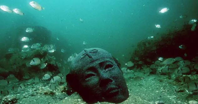
Photo credit: The Guardian
Thonis-Heracleion is hardly known at all today, but it was one of the most important cities in the ancient world. Featured in many ancient Greek stories, it was the place where Heracles first set foot in Africa.
It was also one of the most important cities in ancient Egypt before then, the center of international maritime trade, and the home of people of many different backgrounds and nationalities.
It was first settled over 4,000 years ago and served as Egypt’s trade capital for well over a millennium. It was a cultural mixing pot. Greek and Egyptian armor and weapons have been found together in the city’s sunken depths alongside statues which feature both Hellenic and Egyptian art styles.
It was also a center of religious amalgamation, a place where the new Greek Ptolemaic dynasty was already beginning to be worshiped and depicted in art as Egyptians.[1]
In many ways, it was similar to modern-day Venice: The city was largely built on a series of small islands in a wet lowland area of the Egyptian coast. It was predominantly a maritime city, crisscrossed by waterways and canals and bustling with ships.
And much like Venice today, it was slowly sinking. Near the end of the second century BC, the ground finally gave way and a large portion of the city was either drowned by liquefaction or slipped into the sea. It continued as an insignificant village until the whole city was buried and forgotten around AD 800.
9 Port Royal
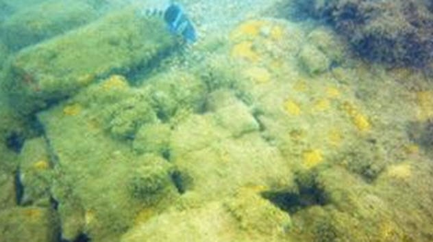
Photo credit: BBC
When the English captured Jamaica from the Spanish, they purposely allowed it to fall into pirate hands. Surrounded by Spanish islands, any pirates who lived there would spend their time harassing Spanish ships rather than English ones, and the presence of armed men on the island at all times would stop the Spanish from conquering it. The city of Port Royal, the biggest settlement on the island, quickly became a pirate haven.
At its height, Port Royal was known as the wickedest city in the world. As a center of both trade and piracy, many who lived there grew extremely wealthy. This ill-gotten wealth attracted a bustling scene of drunkards, whores, and corrupt merchants who all contributed to the town’s reputation.
There was very little government control, so new residents built their homes on any spare patch of land they could find. There were almost no roads or stone buildings to speak of, so when an earthquake struck in 1692, the entire town was practically destroyed.[2]
Today, it is little more than a fishing village, but dozens of the town’s old buildings can still be seen below the water. Locals dream of turning it into a world-class tourist center. But without government support, there’s little they can do.
8 Lost Villages Of Ontario
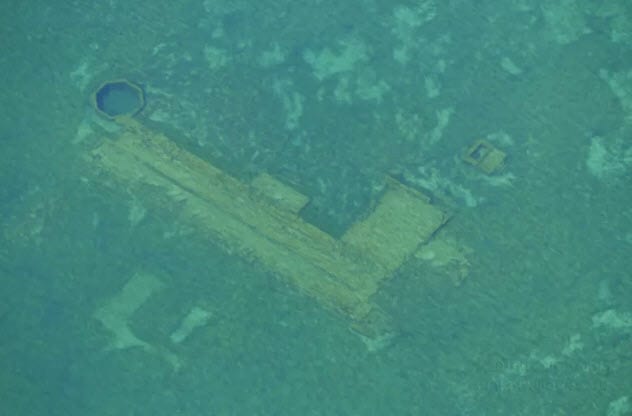
Photo credit: gizmodo.com
In the 1950s, the US and Canada started a joint project to connect the Great Lakes to the Atlantic, allowing ships to travel as far inland as Minnesota. This project, the Saint Lawrence Seaway, was started in 1954 and finished in 1959. It was a great success but with one caveat: It required the flooding of nine Canadian villages.
The communities of Aultsville, Maple Grove, Wales, Santa Cruz, Dickinson’s Landing, Farran’s Point, Moulinette, Mille Roches, and Sheek’s Island were all submerged along with a part of Canada’s Highway 2, which had to be rebuilt further upland. This part of Ontario was one of the oldest in Canada. Many of the villages were first built in the 1700s, and some were built on the sites of former Native American settlements.
Before the arrival of Europeans, much of the area was the territory of the Mohawks. In all, over 6,000 people and over 500 buildings were relocated to newly planned towns. Contrary to what they’d been promised, residents complained that their new homes were not the same value as the ones they’d been made to give up.
Today, the villages are all but inaccessible, submerged at the bottom of a busy shipping lane. They are occasionally visible beneath the water, however, especially when the water is low.[3]
What’s particularly haunting about the lost villages is that it happened so recently. This means that there are many photos across the web of the time when these villages were still in use, featuring people going about their daily lives.
7 Neapolis
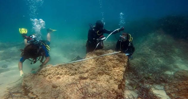
Photo credit: The Independent
The city of Neapolis was one of the most prominent Roman cities in Tunisia when it was hit by a tsunami in July 365. The disaster, which also caused significant damage down the coast at the city of Alexandria, led to Neapolis’s destruction. The city was lost for 1,700 years. Fortunately, it was rediscovered in summer 2017 after seven years of research and hunting by archaeologists.
During its time, Neapolis sided with Carthage in the Punic Wars despite being a Roman town. This led to the Romans all but writing Neapolis out of their records. As archaeologists had long suspected, however, the city proved to be large and sophisticated.
The ruins of streets and monuments proved that Neapolis was fairly developed. The discovery of over 100 tanks used in the production of the fish-based sauce garum has revealed the town’s predominant industry. Garum was a Roman delicacy that was produced on an industrial scale across the Roman Empire, but archaeologists now think that Neapolis may have produced more of the stuff than anywhere else.[4]
6 Vilarinho Da Furna
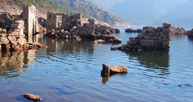
Photo credit: magnusmundi.com
According to local tradition, Vilarinho da Furna was first settled in the first century by a Visigothic tribe. Even as late as the 1970s, this small village of a few hundred people was still using an ancient Visigothic democratic system. Each family in the town got a single vote. Together, they elected a leader, who served a six-month term, from among the town’s married men.
Planning to turn the lands around the village into a reservoir began as early as the 1950s. The government conducted tests and surveys before finally beginning the process in 1967.
The village’s people were warned in 1970. By 1971, they’d all evacuated but not before they’d built a whole new road so that they could get trucks down to the village to move their things. People even stripped the tiles off their roofs. By the time the last person left, most of the houses were simple shells.[5]
What makes Vilarinho da Furna such an impressive site today is that the village emerges from the water during the summer when the water levels are lower. Tourists come to see the old town emerge from the reservoir and to visit the underwater museum, which was established following pressure from the Association of Former-Inhabitants of Vilarinho da Furna. It is now known around the world.
5 Capel Celyn
Bibio CAPEL CELYN
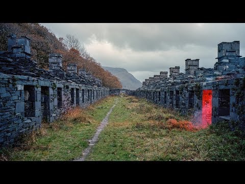
In 1962, the final residents of Capel Celyn moved out. In 1965, the new reservoir of Llyn Celyn, which had drowned the village, was officially opened.
The opening ceremony was supposed to last 45 minutes. But just three minutes in, some local Welsh activists cut the microphone wires, charged down from a nearby hill, and drove the crowd of spectators away. It was the culmination of years of anger.
In the 1950s, Liverpool was one of England’s most unhealthy cities and it was in dire need of a new source of water. After some initial surveys, the valley surrounding Capel Celyn was identified as a good location for a new reservoir for the city.
Unfortunately, the valley lay in Wales and Liverpool was in England. At the bottom of the valley was the Welsh village with only 67 residents. So Liverpool City Council didn’t think there would be an issue and pressed ahead with the plan.
Controversially, they obtained permission for the plan by going through the Houses of Parliament rather than asking the local Welsh council for permission directly. Once the bill had passed Parliament, they issued a land purchase order and set about building the reservoir.
Many in Wales were riled up by the move, and the Welsh nationalist party, Plaid Cymru, saw a spike in membership. Protests were staged across Wales and even at times in the streets of Liverpool itself, where it was said that Welsh protesters spat at and abused locals.[6]
Three young Welshmen planted a bomb which exploded on the construction site. The resulting court case was attended by many Welsh activists who supported their actions.
Despite the activists’ best efforts, the plan went ahead and the residents of Capel Celyn were moved to new properties. The flooding of the town led to a marked increase in Welsh nationalism, however, and the phrase “remember Tryweryn” is still used in Wales today.
In response, the government pushed forward with several initiatives in Wales including more funding for industrial jobs in Llanwern and the first Welsh Language Act.
4 Graun
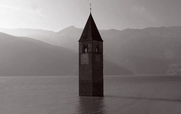
Photo credit: mentalfloss.com
In the early years of the first century, the Romans settled in a valley in the Alps. The small village came to be known as Graun. It thrived through the medieval period, when a large church was built in the town. The church still stands today, 700 years later. Only now instead of being surrounded by townhouses, it is engulfed by water.
The church’s bell tower is all that marks what was once a village with nearly 200 homes. In 1939, the Italian Montecatini company drew up plans to build a hydroelectric dam. The region contained two smaller lakes. But they planned to flood the valley that lay between them, creating one large lake. It was hoped that this would produce enough power to support the region.
Local resistance had already forced the cancellation of a similar project in the Alps just years earlier, and locals were intent on doing it again. In the meantime, Italy was dragged into World War II. The project was put on ice. Once the war was over, however, they brought it back with more force and the plan passed: The village and its surroundings were submerged in 1950.[7]
Due to the cold environs, the lake freezes over in winter, allowing tourists to cross the water and touch the old bell tower. Locals say that the bells can be heard ringing some nights, but the bells were removed in July 1950.
The lake itself is around 22 meters (72 ft) deep, making a diving trip to the old ruins feasible. Unfortunately, such an expedition is probably not legal.
3 Potosi
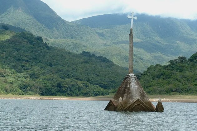
Photo credit: The Independent
In 1985, the Venezuelan government also planned to flood an inhabited valley to build a hydroelectric dam. They did it with much less tact, though.
Then-president Carlos Andres Perez flew into the town by helicopter and told the residents that their land was going to be expropriated and they had to leave. The 1,200 residents scattered to live with family and friends across Venezuela, and much of the town was demolished.
For a long time, the only marker that remained of the town was the church’s steeple, which jutted out of the water and was used by local people as a high-water mark.
This was until 2010, when Venezuela was affected by a particularly severe El Nino effect. It triggered a drought that hit much of the country. The reservoir’s water levels dropped by 30 meters (98 ft), triggering energy rationing across Venezuela.
But it also meant that the whole church—including the graveyard—was once again on dry land along with a few old houses and the town square. Some of the old residents took the opportunity to visit their old home and pay their respects before it was submerged once again when the drought ended.[8]
2 Petersburg
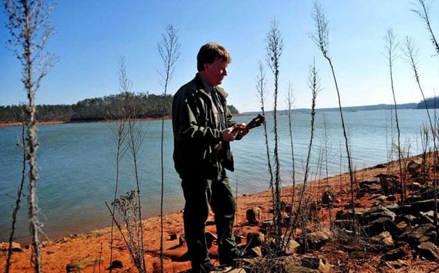
Photo credit: jacksonville.com
Lake Strom Thurmond (aka Clarks Hill Lake) is a popular destination for tourists and swimmers in Georgia today. What is less known, though, is that it conceals the once-thriving town of Petersburg beneath its choppy water.
Petersburg was settled in 1786 by Dionysius Oliver to take advantage of the burgeoning plantation economy of the Broad River Valley region. It quickly became a key outpost in the tobacco industry and one of the main places where shipments were inspected.
By 1801, it was the third-biggest town in Georgia. Visitors described it as a handsome town that was a center of trade and culture, which only did more to boost its popularity.
It was clearly a town of convenience, however, and its fate was tied up with that of the tobacco plantations. By 1810, the cotton industry was taking over and Petersburg fell into decline.
The town was practically deserted by the time it lost its post office in 1844. By 1952, when the US Army Corps of Engineers began filling the valley to create a lake, the town was abandoned and forgotten.[9]
So naturally, the locals were surprised when a local drought caused the town to emerge from the lake in 2002. Old fences, bits of pottery, and the foundations of houses were all on view for days before the water returned to its original height.
The town has since emerged several times, all during periods of hot weather. Its spooky Victorian appearance made it a tourist trap.
1 Shi Cheng
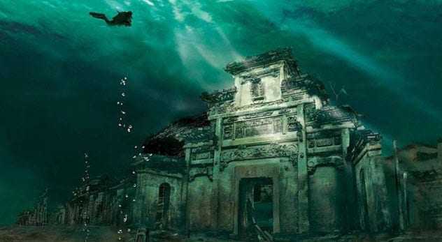
Photo credit: BBC
In the past, China has been criticized for moving vast numbers of people in the pursuit of public works projects. The creation of the Qiandao Lake required the relocation of over 300,000 people, some of whom had family who had lived in the region for generations.
One of the biggest tragedies of this operation, however, was the loss of the imperial city of Shi Cheng, an old Ming city with impressive monuments dating back to at least the 1500s and probably centuries before. A city has existed there since 208. The region was flooded in 1959, and now the city lies at the bottom of a 40-meter-deep (130 ft) lake.
The city was forgotten until 2001 when the Chinese government organized an expedition to survey the ruins and discover what was left. To their surprise, the flooding had preserved the old stone buildings extremely well.
Protected from the usual soil, wind, and rain erosion, the city now looks almost exactly as it did when it was flooded. Shi Cheng serves as one of the best-preserved collections of artifacts from the Imperial Period in all of China.
In 2011, a project to recreate what the city may have looked like in the past cultivated further public interest. Today, there are several schemes for experienced divers to go down with a group and see the “Atlantis of the East” in person.[10]
These dives are still considered exploratory in fashion. Mapping of the lake’s floor continues, with divers having identified several more sites of historic interest.
For more fascinating facts about submerged cities, check out 10 Mysterious Underwater Cities You Haven’t Heard Of and 10 Sunken Cities (That Are Not Atlantis).
More Great Lists
 Top 10 Facets Of Modern Life Which Appeared In 1700s Britain
 Top 10 Reasons You Can't Trust Science Right Now
 Top 10 Disturbing Things Facebook Knows About You Right Now
 Top 10 Under-Appreciated TV Shows You Can Binge Right Now
 Top 10 Truly Terrible Things that are Legal Right Now
 8 Alien Abductions That Suggest Underwater Alien Activity
 Top 10 Underwater Ruins Of Lost Civilizations
 10 Eerie Abandoned Animal Parks
![10 Abandoned Amusement Parks With Horrific Histories [Disturbing]](https://listverse.com/wp-content/uploads/2019/09/gulliver-150x150.jpeg "10 Abandoned Amusement Parks With Horrific Histories [Disturbing]") 10 Abandoned Amusement Parks With Horrific Histories…
10 Abandoned Amusement Parks With Horrific Histories…
fact checked by
Jamie Frater
More Great Lists