 Space
Space
Space
Space  Movies and TV
 10 Film Productions That Went Too Far
 Weird Stuff
 10 Historical Facts That Ruin Your Timeline
 History
 10 Maritime Folktales with a Real-Life Twist
 Crime
Crime 10 Notorious Prison Gangs That Became Criminal Empires
 Music
Music Top 10 Hit Song Lyrics That Became Cultural Catchphrases
 Weird Stuff
 10 Bizarre Viral Trends That Took Things Too Far
 Weird Stuff
 10 Plants That Eat Animals
 Movies and TV
 10 Mind-Boggling Reasons These Blockbusters Became So Expensive
 Misconceptions
 10 Common Misconceptions About Famous Scientists
Space 10 Amazing Explanations for Cosmic Conundrums
Movies and TV 10 Film Productions That Went Too Far
Weird Stuff 10 Historical Facts That Ruin Your Timeline
Who's Behind Listverse?

Jamie Frater
Head Editor
Jamie founded Listverse due to an insatiable desire to share fascinating, obscure, and bizarre facts. He has been a guest speaker on numerous national radio and television stations and is a five time published author.
More About Us
History 10 Maritime Folktales with a Real-Life Twist
Crime 10 Notorious Prison Gangs That Became Criminal Empires
Music Top 10 Hit Song Lyrics That Became Cultural Catchphrases
Weird Stuff 10 Bizarre Viral Trends That Took Things Too Far
Weird Stuff 10 Plants That Eat Animals
Movies and TV 10 Mind-Boggling Reasons These Blockbusters Became So Expensive
Misconceptions 10 Common Misconceptions About Famous Scientists
10 Stories Behind Astounding Space Pictures Of Earth
Even after humans fought for centuries to escape the restrictions of this world and thus be able to venture into the cosmos, we finally decided to look back. So, ironically, Earth has been the primary focus of our observations from space.
Although scientists have obtained hundreds of thousands of photographs of planets, galaxies, and other places in the universe, pictures of Earth from space are counted in the millions. Thanks to space technologies, we have photographed and analyzed every corner of our planet from a celestial perspective, ultimately expanding our understanding of the world in which we live to an unprecedented level.
But among so many images of Earth, only a handful have been able to remain in the collective memory until today. The spectacular landscapes contained in these images, as well as the peculiar situations that led to their creation, can sometimes be the factors that have given them such recognition.
In the list below, we will cover 10 of the best space pictures of Earth—some iconic, others little-known, but each with an amazing story to tell.
10 A Shooting Star Seen From Above
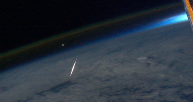
Photo credit: space.com
When we try to remember what a shooting star looks like, it is almost intuitive to imagine ourselves looking up at the night sky while a bright fireball flies overhead. It is natural as we have become accustomed to seeing shooting stars only from down here on the Earth’s surface.
But this is not the case for everyone. On August 13, 2011, an astronaut aboard the International Space Station (ISS) took a photograph of Earth while the station was over China. What makes this image special is that it shows a small light streak crossing the Earth’s atmosphere.[1]
The astronaut tweeted the photograph along with a caption that said: “What a ‘Shooting Star’ looks like from space, taken yesterday during Perseid Meteor Shower.” Indeed, the light was actually a bright meteor seen from above. As the tweet indicates, the shooting star was part of the Perseid meteor shower, an event that occurs every year in August.
Due to the interest of scientists to see such a meteor shower from space, a camera installed on the ISS has been recording the event since 2016 and producing some breathtaking videos. Now that it is possible to see meteors from space without any atmospheric distortion, the scientific community has a better understanding of the composition of meteorites that hit our planet.
9 Floating With The Whole World Below
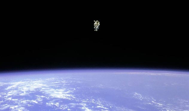
Photo credit: NASA
The following story not only involves an amazing image of the Earth but also a peculiar feat of the human race. In 1984, NASA conducted a mission to test a prototype space jetpack for astronauts. It was called the Manned Maneuvering Unit (MMU).
In February of that year, astronaut Bruce McCandless flew into space for the first time aboard the space shuttle Challenger to test the jetpack. After some tests inside the spacecraft, McCandless ventured into the void of space with the MMU on his back. Thus, on February 7, 1984, McCandless became the first human to make a spacewalk completely free of anchors to his ship.[2]
The moment was immortalized in a panoramic image taken from Challenger while Bruce was floating about 98 meters (320 ft) away from the shuttle. The photo speaks for itself: It was only him and his jetpack in the middle of the blackness of outer space and with the blue vastness of the Earth under his feet.
Before his death in December 2017, McCandless confessed to National Geographic that he did not stop to look down at Earth during his untethered flight. Nevertheless, he did notice that he was flying over the state of Florida at one point.
But McCandless also said that being able to observe the entire Earth from space definitely changes an astronaut’s perception of the world and our ephemeral divisions as a species.
8 Light And Darkness
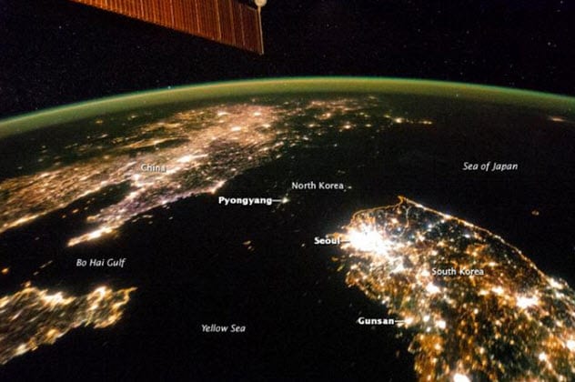
Photo credit: National Geographic
After the Korean War ended in 1953, both South Korea and North Korea had similar economic levels. But while South Korea’s economy continued to grow in the following decades, North Korea sank into poverty.
In the 1990s, the Soviet Union collapsed and stopped supplying fuel to North Korea, one of its “spoiled” countries. Added to a devastating famine in North Korea around the same time, this fuel stoppage caused the energy supply in the country to be drastically reduced.
There is no better way to see the precarious energy infrastructure of North Korea than through images taken from space. In January 2014, an astronaut aboard the International Space Station (ISS) photographed the Korean peninsula during nighttime.
In the upper section of the picture, we can see China, while the brilliant South Korea stands out in the lower right corner. Between both countries, there is an almost completely dark hole which blends in perfectly with the blackness of the surrounding seas. But that is actually North Korea.
The most remarkable spot of light in North Korea comes from its capital, Pyongyang, which a decade ago had more than three million inhabitants. However, the light from Pyongyang is barely comparable to the glow of the smaller towns in South Korea.
When the image from the ISS was publicly released, North Korea promptly made some statements, claiming that “the essence of [its] society is not on flashy lights.” Despite that, North Korea’s leader, Kim Jong Un, told his citizens to work hard to restore electricity in the country.[3]
7 The First Space Selfie
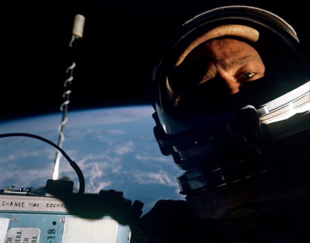
Photo credit: petapixel.com
Almost everyone sees taking selfies as a common practice. In fact, it is estimated that people around the world take a total of more than one million selfies per day. Usually, many of these pictures are taken in some special, nice-looking place around Earth.
But taking a selfie in outer space and having the entire Earth in the background is a privilege granted only to a few. This type of photograph, by the way, is known as a “space selfie.”
In November 1966, NASA carried out a space mission called Gemini 12 to test the ability of astronauts to dock with another orbiting spacecraft. One of the crew members was Buzz Aldrin, who would later become the second man to step on the Moon.
Gemini 12 was the first space flight for Aldrin, and he spent a record-breaking five and a half hours outside his ship. The astronauts had a camera to record facts related to the mission. But Buzz had the idea to test the camera on himself.[4]
To do so, the astronauts had to change the direction of the spacecraft. As the camera was mounted on the ship itself, the crew rotated it to the right angle and shut off the thrusters so that they did not flash in the photo.
With the hatch of the spaceship open, Buzz stood in his seat and clicked the camera in front of him. In that way, one of the first humans to step on the Moon also ended up being the first person to take a space selfie. As an interesting fact, the picture was sold for $9,200 at an auction in 2015.
6 Blue Marbles
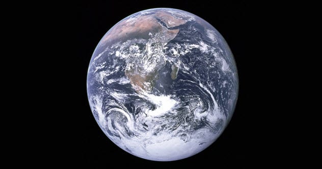
Photo credit: NASA
In what would end up being the last manned mission to the Moon until this day, the crew of Apollo 17 took off from Earth on the night of December 7, 1972. Throughout the journey, the astronauts Eugene Cernan, Harrison Schmitt, and Ron Evans had to stick to a complex routine to maneuver the huge Saturn V rocket that took them to our natural satellite. For that reason, they could not take pictures or get distracted by looking out the window.
But when they were about 45,000 kilometers (28,000 mi) away from Earth, one of the astronauts could not help looking back at our world. With the only camera he had within reach at that moment, he decided to photograph such a unique view of Earth. Indeed, it turned out to be the first color image in which the entire planet can be seen.
The image was an international sensation, appearing on the front page of countless newspapers around the world. In fact, as the picture—now known as “The Blue Marble Shot”—is in the public domain, it is even believed to be the most reproduced image in history. The astronauts of Apollo 17 never agreed on which one of them took the photograph.
During the following decades, NASA published other images of Earth similar to the one from 1972. But all those were composite images made with multiple pictures taken at different times. It was not until 43 years later that we were once again able to get a genuine Blue Marble shot, thanks to an observation satellite known as DSCOVR.
The satellite was launched in 2015 as a joint effort between NASA and the National Oceanic and Atmospheric Administration. As its orbit gives us a continuous view of the sunlit face of the Earth, a new full-view picture of our world was possible.[5]
5 Eclipses As Seen From Space
Total Solar Eclipse 2017 observed by DSCOVR EPIC (4K)

As total solar eclipses occur about once every 18 months at some given place on Earth, humans have recorded such phenomena from space several times. For example, astronauts on the now-destroyed Mir space station took a spectacular photograph of a total solar eclipse darkening the Earth in August 1999. But if we must highlight a recent solar eclipse, let’s look at the one that occurred on August 21, 2017, over North America.
The eclipse was partial in the entire United States and total in 14 states. Besides having been greatly anticipated by scientists because of the opportunity to study such a phenomenon, the eclipse was also one of the most watched events in US history.
Making good use of its technology, NASA recorded this eclipse in great detail. From about 1.6 million kilometers (1 million mi) away from us and through the DSCOVR satellite previously mentioned, the agency obtained 12 images of the path of the Moon’s shadow on the surface of the Earth.
The result is a video sequence of a few seconds that shows the eclipse as seen from space crossing the entire visible hemisphere of our planet. DSCOVR usually takes about 20 pictures of Earth per day. But in view of the occasion—and for research purposes—the scientists decided to configure the instruments to take more images that day. Even so, the video shows the movement of the eclipse at a faster speed than what actually occurred.[6]
4 A Pale Blue Dot

Photo credit: medium.com
In 1977, NASA launched two spacecraft called Voyager to explore the planets beyond Earth. Thirteen years later, the probe called Voyager 1 was already approaching the confines of our solar system.
It was then—on February 14, 1990—that the engineers decided to turn the spacecraft’s camera to take a last look back at our planetary neighborhood. From about 6.4 billion kilometers (4 billion mi) away from us, farther than any other human machine had flown before, Voyager 1 took 60 photographs to create the first “portrait” of the solar system.
In one of the images, several bands of color can be seen. They are light rays because the Sun was close to the shot. Near the center of the picture in the middle zone of one of the stripes, we can see Earth. Our planet, shown there as a small dot 0.12 pixels in size, has no visible features beyond its brightness and is almost indistinguishable from the darkness of space.
In 1994, the famous astronomer Carl Sagan published a book in which he commented on this image of our world, which he called a “Pale Blue Dot.” About it, Sagan said: “[E]veryone you love, everyone you know, everyone you ever heard of . . . lived there—on a mote of dust suspended in a sunbeam.”[7]
3 When A Satellite Discovered A Deadly Island
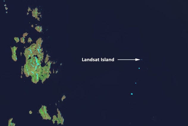
Photo credit: amusingplanet.com
As part of NASA’s Landsat program, the Earth Resources Technology Satellite (ERTS-1) was launched into space in 1972 to photograph the Earth’s features and landmasses for the first time. In 1973, researcher Elizabeth Fleming was analyzing the new images transmitted by ERTS-1 to find uncharted islands off the coasts of Canada. Among the less explored regions were the northern coasts of the province of Labrador, which had been charted for the last time in 1911.
When Fleming studied the images, she noticed some white spots scattered in the ocean which she thought were icebergs. But she soon realized that they were small portions of dry land. One land patch, located about 20 kilometers (12.4 mi) away from the Labrador coast, caught her attention.
It was larger than the rest, measuring 25 meters (82 ft) by 45 meters (148 ft). So it was legally an island—a newly discovered one. In 1976, Dr. Frank Hall from the Canadian Hydrographic Service was given the task of confirming the existence of the small island.
Using a harness, Hall was lowered from a helicopter to the island, which was covered in ice. Suddenly, when Hall was about to touch the ground, a polar bear tried to bring him down and have him for lunch. The bear was in the highest part of the island and unnoticeable due to its white fur.
Immediately, Hall pulled the cable and got back into the helicopter by himself. According to his words, he almost became the first person to die on that island. After the experience, Hall suggested that the site be called Polar Island.
But it was finally called Landsat Island in 1979 when its discoverer satellite, ERTS-1, was renamed Landsat 1. Satellite images are inherently amazing, but the story behind this one makes it even more impressive.[8]
2 The First Photo Taken From Space
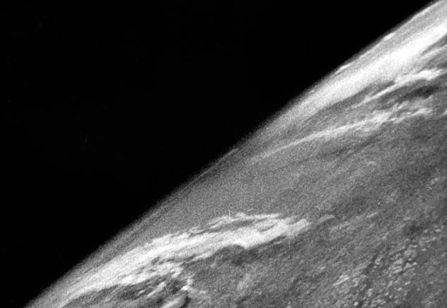
Photo credit: cosmosmagazine.com
During the first half of the 20th century, people did not really know what the Earth looked like from space. Until then, the highest we had been to take pictures of our own world was about 22 kilometers (13.7 mi) high in giant balloons. But that changed in 1946 when we acquired a way to travel higher.
After the end of World War II, the Americans had captured V-2 rockets originally developed by the Nazis. The destructive weapons that were once responsible for thousands of deaths were now in the hands of scientists in the United States, who replaced the explosives of the missiles with observation instruments.
One V-2 rocket was equipped with cameras designed to take pictures every second and a half. On October 24, 1946, the former missile flew to a height of 105 kilometers (65 mi). From there, it took what would be the first photograph of Earth from space.
In the image, we can see the southwest of North America under some cloud formations as well as the detail of the curvature of the Earth. Once its mission was completed, the rocket fell back to Earth. What was left of it, including the camera, crashed to the ground at about 550 kilometers per hour (342 mph).
But the recording tape survived intact because it was protected in a steel can. So the researchers retrieved the images and analyzed them. The enthusiasm of the scientists for this achievement was remarkable. In 1950, an article from National Geographic stated that the images showed “how our Earth would look to visitors from another planet coming in on a space ship.”[9]
1 Earthrise
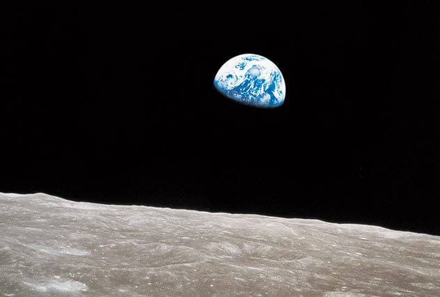
Photo credit: time.com
The first manned mission to the Moon, Apollo 8, took place on December 21, 1968. Its crew of three astronauts—Frank Borman, Bill Anders, and James Lovell—became the first humans to leave Earth’s orbit and reach another planetary body. Apollo 8’s goal was to orbit the Moon and search for potential landing sites for future lunar missions.
As the astronauts emerged from the far side of the Moon during their fourth orbit on December 24, they noticed a blue sphere rising over the lunar horizon. It was Earth, shining through one of the spaceship’s windows.
As it was a reconnaissance mission, the crew was not supposed to take pictures of Earth. Moreover, at that time, they were preparing to recite passages from the Bible’s Book of Genesis during a live broadcast. But the astronauts were so amazed at such a view of the little crescent Earth that they felt compelled to photograph it.
For a moment, they believed that they had lost sight of Earth. But as soon as Lovell saw it again in another window, Anders managed to take a color photograph of it. After that, the astronauts continued with their routine and read from Genesis to end the broadcast as planned.
The photo, which we now know as “Earthrise,” became one of the most famous images in history and served as inspiration for the creation of environmental movements such as Earth Day. After the flight, Anders said, “We came all this way to explore the Moon, and the most important thing is that we discovered the Earth.”[10]
Brian Molinari is an economy student who is passionate about graphic design as well as an avid enthusiast of the art of writing.
Read about more amazing images of space on 10 More Amazing Images Of Space Pareidolia and 10 More Stunning Images Of Space.
More Great Lists
 10 Times A Meteor Fell To Earth And Flew Back Into Space
 10 Bizarre Stories Behind US State Flags
 10 Stories Behind Incredible Pulitzer Prize--Winning…
 10 Interesting Stories Behind The Invention Of Modern Foods
 Top 10 Behind-The-Scenes Stories From The Best Action Movies
 10 Weird Place Names And The Stories Behind Them
 10 Astounding Facts You Didn't Know About Skyscrapers
 10 Astounding Facts About Extremely Low Temperatures
 10 Astounding Facts About Nostalgia
fact checked by
Jamie Frater
More Great Lists