 Crime
Crime
Crime
Crime  Our World
 10 Rare Hybrids with Wild Backstories
 Space
Space 10 Amazing Explanations for Cosmic Conundrums
 Movies and TV
 10 Film Productions That Went Too Far
 Weird Stuff
 10 Historical Facts That Ruin Your Timeline
 History
 10 Maritime Folktales with a Real-Life Twist
 Crime
Crime 10 Notorious Prison Gangs That Became Criminal Empires
 Music
Music Top 10 Hit Song Lyrics That Became Cultural Catchphrases
 Weird Stuff
 10 Bizarre Viral Trends That Took Things Too Far
 Weird Stuff
 10 Plants That Eat Animals
Crime 10 Infamous Crime Scenes That Became Tourist Hotspots
Our World 10 Rare Hybrids with Wild Backstories
Space 10 Amazing Explanations for Cosmic Conundrums
Who's Behind Listverse?

Jamie Frater
Head Editor
Jamie founded Listverse due to an insatiable desire to share fascinating, obscure, and bizarre facts. He has been a guest speaker on numerous national radio and television stations and is a five time published author.
More About Us
Movies and TV 10 Film Productions That Went Too Far
Weird Stuff 10 Historical Facts That Ruin Your Timeline
History 10 Maritime Folktales with a Real-Life Twist
Crime 10 Notorious Prison Gangs That Became Criminal Empires
Music Top 10 Hit Song Lyrics That Became Cultural Catchphrases
Weird Stuff 10 Bizarre Viral Trends That Took Things Too Far
Weird Stuff 10 Plants That Eat Animals
10 Fascinating Facts About The Continents
We probably pay less attention than we should to the continents on Earth. How many are there anyway? Seven? Well! That depends on what you were taught in school. The word “continent” has no definite meaning, and countries recognize from four to seven continents.
Most countries need to update their books soon because there is an extra continent right underneath the island nation of New Zealand. They will also need to add another continent when Africa splits into two. And they would have added an extra one if North America had successfully split into two continents and stayed that way.
10 Africa Is Splitting In Two
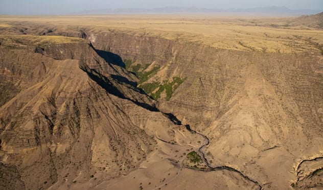
Photo credit: Live Science
Africa sits on two tectonic plates. Most African nations sit on the African Plate, which is often called the Nubian Plate to avoid confusion. However, several East African nations sit on the Somali Plate. Both plates are currently moving and slowly tearing Africa apart.
Evidence of the split is visible in Kenya, where it has created a deep and long valley called Kenya’s Rift Valley. It is part of several valleys called the East African Rift. The valleys randomly appear along a 2,900-kilometer-long (1,800 mi) region directly on the area where both plates meet.
East Africa will break away to become a new continent when they finally separate. For now, they have caused a series of earthquakes and volcanic activities as they move farther apart.
On March 19, 2018, the movement of the plates even caused a crack in Kenya that was 15 meters wide (50 ft) and several miles long. However, some sources say that this valley was actually caused by soil erosion and not the movement of tectonic plates.
There is no reason to fret, though. The split is a slow one, and it will be millions of years before Africa finally breaks up.[1]
9 Antarctica Is Supposed To Be Called Australia
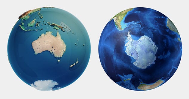
For centuries, scientists, explorers, and geographers predicted the existence of a continent in the southern hemisphere. They called this continent terra australis incognita (“unknown southern land”). Australis itself means “southern.” No one was sure if the continent existed, but they believed it did because the Arctic existed up north.
In 1627, the Dutch landed on today’s Australia. They sailed around the northern, western, and southern coasts of the continent and named it New Holland. The British would later land on the eastern coast, which they called New South Wales.
Curiously, no one realized that they were dealing with the same continent. Early explorers thought that New Holland and New South Wales were different continents separated by a strait. It wasn’t until 1803 that Matthew Flinders circumnavigated New Holland and New South Wales and revealed that they were different areas of the same continent.[2]
In 1814, Flinders released the map of the continent, which he called “Terra Australis.” However, he suggested that “Terra Australis” should be shortened to the better-sounding “Australia.” The name stuck.
Antarctica was discovered by Charles Wilkes of the US on January 19, 1840. It was named Antarctica because its intended name, Terra Australis, was already taken. Antarctica was coined from the Roman translation of the Greek antarktike, which basically means “anti-Arctic” or “opposite the Arctic.”
8 There Are From Four To Seven Continents Depending On Whom You Ask
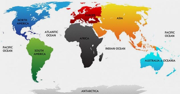
Photo credit: worldatlas.com
There is no agreed definition of what is considered a continent. Ideally, single masses of land on the same tectonic plate should be considered a continent. However, this is not used because India and the Arabian peninsula have individual tectonic plates not shared with other Asian nations, even though they are considered parts of Asia.
The more common method is geopolitics. For this reason, Europe and Asia are considered different continents even though they lie on the same tectonic plate and are not separated by an ocean. The problems with defining a continent explain why we have from four to seven continents today.
The seven-continent model—which is mostly taught in China, Pakistan, India, and English-speaking countries—lists the continents as Africa, Antarctica, Asia, Australia (or sometimes, Oceania), Europe, North America, and South America. The six-continent model—which is taught in France, Spain, and other parts of Europe—mirrors the seven-continent model except that North and South America are considered the same continent called America.
Japanese and Eastern European schools also teach a six-continent model. However, they consider North and South America as different continents. Meanwhile, Europe and Asia are lumped into a single continent called Eurasia.
The United Nations uses a five-continent model that recognizes Africa, America, Antarctica, Australia, and Eurasia. There is also the four-continent model that considers Africa, Europe, and Asia as a single continent called Afro-Eurasia. The three other continents are America, Antarctica, and Australia.[3]
7 New Zealand Lies On A Separate Continent
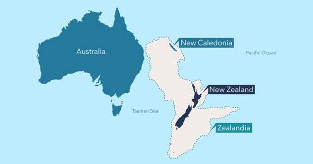
Photo credit: utas.edu.au
New Zealand is often lumped with Australia to form Oceania, which also includes several other Pacific islands. However, New Zealand has been confirmed to lie on its own continent called Zealandia. We just do not get to see it because 94 percent is underwater. The other 6 percent consists of several island nations and territories including New Zealand and New Caledonia.
Zealandia measures about 4.9 million square kilometers (1.9 million mi2), which makes it two-thirds the size of Australia. Researchers believe that Zealandia went underwater 80 million years ago after it broke off from a larger supercontinent called Gondwana.
However, Zealandia could not keep its head above water and soon went under. Nevertheless, it is unlikely that most models will add this extra continent anytime soon. There is no international organization to declare the existence of continents, so individual nations will need to determine what they teach in their schools.[4]
6 Greenland Is Part Of North America
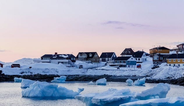
Photo credit: worldatlas.com
Greenland is an autonomous region of the Kingdom of Denmark. Denmark, a neighboring nation, is also part of the Kingdom of Denmark. While Denmark is located in Europe, Greenland is located in North America even though it is often considered a part of Europe.
Some sources even list it as a transcontinental country—that is, a country that is split between two continents. Greenland is a part of North America because it sits on the North American tectonic plate which is shared by several North American nations, including the US and Canada.
Greenland’s relationship with North America goes further than just tectonic plates. North American migrants were the earliest cultures to settle in Greenland. This included the Paleo-Eskimo tribes that arrived in Greenland in the 26th century BC and the Saqqaq people that lived there from the 25th century BC until the ninth century BC.
Later settlers included the Dorset, the Independence I, and the Independence II cultures, which all migrated from Canada. In fact, the current natives of Greenland are the Kalaallit people, who migrated from North America in the 13th century.
However, Greenland was named by the first Europeans who arrived in AD 986. The migrants had fled Iceland where they were being persecuted by the king of Norway. They called the island “Groenland” as part of a ploy to attract new settlers to the region.[5]
5 Antarctica Is The World’s Largest Desert
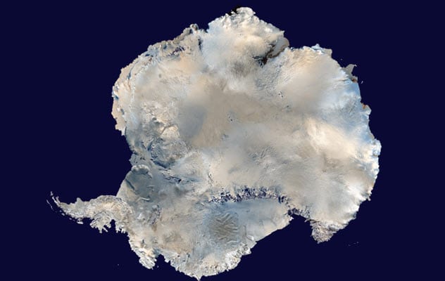
Photo credit: universetoday.com
Although we often consider Antarctica as a barren wasteland covered in ice, it is actually a desert. This is because deserts are not determined by higher-than-normal temperatures and lots of sand. Instead, a desert has everything to do with precipitation, the amount of water the area receives from the atmosphere.
An area is considered a desert if it loses more water than it receives from the atmosphere. The water can be delivered as rain, snow, mist, fog, etc. At the same time, the area must receive less than 250 millimeters (9.8 in) of water from the atmosphere per year. Antarctica receives less than 51 millimeters (2 in) of water annually in its innermost areas.
Besides being the largest desert on Earth, Antarctica also contains the driest place on the planet. Rain, snow, or ice has not fallen in the aptly named 4,800-square-kilometer (1,900 mi2) Dry Valleys in two million years. Winds from nearby mountains contain lots of water but are so heavy with moisture that gravity pulls them away from the Dry Valleys.[6]
4 No One Knows Where The Border Is Between Europe And Asia
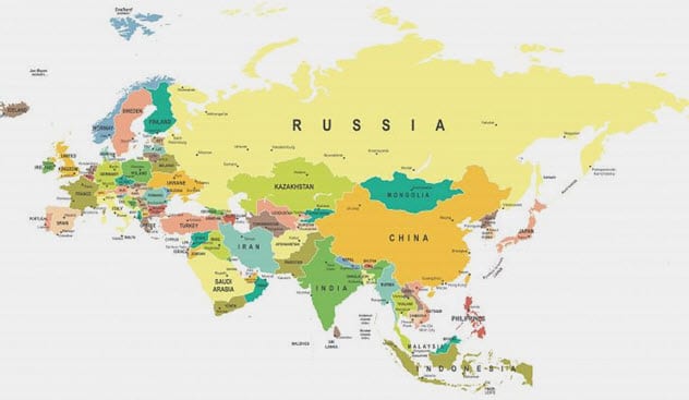
Photo credit: worldatlas.com
We already mentioned that Europe and Asia are actually on the same physical continent, although they are considered to be separate continents from a geopolitical standpoint. There is no sea bordering them, and most nations in both Europe and Asia lie on the same tectonic plates. However, India lies on the Indian Plate, several Arab nations lie on the Arabian Plate, and parts of Russia lie on the North American Plate.
Today, no one knows where the actual border is between Europe and Asia. The de facto border created by Philip Johan Von Strahlenberg, an explorer and officer of the Swedish army, goes through the Aegean Sea and down the Caspian Sea, past the Turkish Strait, Black Sea, and Greater Caucasus before terminating in the Ural River and Ural Mountains.
However, this and several other considerations are controversial. Several nations have often ended on the other continent or right at the border between both continents. For instance, Strahlenberg’s border puts 75 percent of Russian citizens in Europe even though Russia is considered an Asian nation.
Other suggestions have caused problems for nations like Cyprus, which ended up in Asia even though it is considered a European nation. Georgia has also ended up in Europe and sometimes right at the border between Europe and Asia even though it is considered an Asian nation. This is why geographers often lump Europe and Asia into Eurasia.[7]
3 Every Map You Have Been Reading Is Wrong

Maps can never be accurate. Every map you have been reading is wrong because they are often made in 2-D even though the world is in 3-D. The Earth is not a perfect sphere, so it is nearly impossible to create a map of the Earth on a rectangular sheet of paper.
As a result, 2-D maps cannot depict the real size of continents and simultaneously maintain the correct longitude and latitude. Cartographers believe that the longitude and latitude lines are more important, so they opt to distort the size of the continents instead. This is commonly seen in the Mercator Map, which is the most common map out there.
The Mercator Map depicts North America as a larger continent than Africa. Greenland is almost the same size as Africa, and Alaska is larger than Brazil. India also looks notoriously small even though it is larger. Meanwhile, Antarctica appears larger than it really is.[8]
In truth, Africa is three times bigger than North America and 14 times larger than Greenland. Africa is so large that the US, India, China, Japan, and the whole of Europe will fit in it with space left over. Brazil is five times bigger than Alaska, and India is three times larger than Scandinavia.
2 North America Almost Split In Two
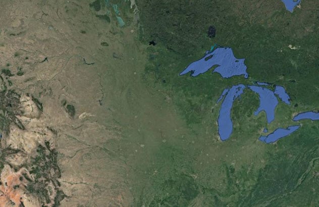
Photo credit: Smithsonian Magazine
Africa is not alone in possessing a rift valley. North America also has the Midcontinental Rift System that almost split the US into two about 1.1 billion years ago. The rift started in Michigan and extended down into the Midwest before mysteriously stopping.
Researchers are unsure why the rift stopped. However, they know that it would have linked with the ocean to create a new ocean that would have sliced North America into two continents. Today, evidence of the rift system can be seen in the 3,200-kilometer-long (2,000 mi) valley below the Great Lakes in the northern Midwest.[9]
1 North America Once Split Into Two Continents
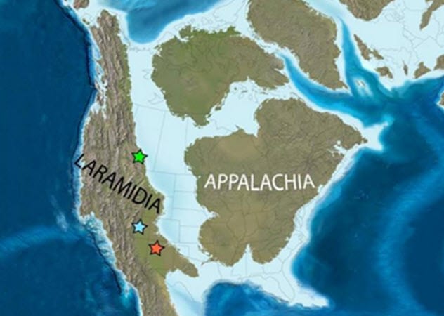
Photo credit: paleontologyworld.com
North America did really split into two continents in the Late Cretaceous Period that occurred from 100.5 million to 66 million years ago. (For clarity, the entire Cretaceous Period began about 145 million years ago and ended 66 million years ago.)
The split had nothing to do with the rift valley, though. Instead, North America split after rising sea levels saw the ocean breach the coastline and spill into low regions in the middle of the continent. Researchers call the ocean that emerged the “Western Interior Seaway.” It began at the Arctic Ocean and ended at the Gulf of Mexico.
Researchers call the two continents “Laramidia,” which was in the west, and “Appalachia,” which was in the east. Laramidia went from Alaska down to Mexico. It was one-third the size of today’s North America, which makes it the same size as Australia.[10]
Laramidia and Appalachia existed for millions of years until the sea started to dry up 70 million years ago. Researchers believe that the sea dried up as the North American tectonic plate moved and the Earth got cooler.
Read more fascinating facts about our continents on 10 Things You May Not Have Known About The Land Of Pangaea and 10 Forgotten Lands Submerged By The Ocean.
More Great Lists
 Top 10 Fascinating Facts About Magnetic Fields
 10 Fascinating Facts About The American Flag
 10 Fascinating Facts About The Bugs Living In Your Guts
 10 Fascinating Facts About The Frightening Megalodon
 10 Times Ancient Bodies Revealed Fascinating Facts…
 Top 10 Fascinating Facts And Firsts Of Historical…
 10 Fascinating Facts About A Corpse That Helped The…
 10 Fascinating Lesser-Known Facts About Famous People
 Top 10 Fascinating Facts And Stories About Sharks
fact checked by
Jamie Frater
More Great Lists