 Movies and TV
Movies and TV
Movies and TV  History
 10 Wild Stories About America’s Most Fascinating Founding Father
 Our World
 10 Astonishingly Valuable Things Their Owners Simply Walked Away From
 Humans
 10 Disturbing Communities from the Dark Corners of the Internet
 Movies and TV
 10 Hollywood Style Choices That Backfired
 Weird Stuff
 10 Ancient Chores That Would Horrify Modern Health Inspectors
 Politics
 10 Strange High-Tech Tools Shaping Modern Politics
 Humans
 10 Extraordinary Places Humans Have Adapted to Live
 Weird Stuff
 Ten of the Strangest Things You Can Buy Online
 Movies and TV
 10 Crime Shows with Gorgeous Settings
Movies and TV 10 Amazing Lost Films That Were Found Again
History 10 Wild Stories About America’s Most Fascinating Founding Father
Our World 10 Astonishingly Valuable Things Their Owners Simply Walked Away From
Who's Behind Listverse?

Jamie Frater
Head Editor
Jamie founded Listverse due to an insatiable desire to share fascinating, obscure, and bizarre facts. He has been a guest speaker on numerous national radio and television stations and is a five time published author.
More About Us
Humans 10 Disturbing Communities from the Dark Corners of the Internet
Movies and TV 10 Hollywood Style Choices That Backfired
Weird Stuff 10 Ancient Chores That Would Horrify Modern Health Inspectors
Politics 10 Strange High-Tech Tools Shaping Modern Politics
Humans 10 Extraordinary Places Humans Have Adapted to Live
Weird Stuff Ten of the Strangest Things You Can Buy Online
Movies and TV 10 Crime Shows with Gorgeous Settings
Top 10 Hidden Grave Sites Found With Satellite Images
With the dawn of emerging technologies, discoveries made by “space archaeologists” are happening all the time. Although high-powered satellite images are used in universities, some people have been successful with Google Maps and Google Earth, finding hidden sites from thousands of miles away. One of the most fascinating trends in these discoveries is uncovering tombs and cemeteries where the remains of so many people were lost for years.
10 The Forgotten Jewish Cemetery Of Plymouth
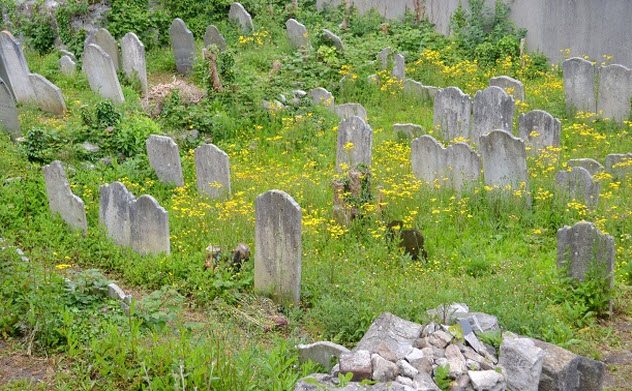
Photo credit: plymouthherald.co.uk
In 2016, Jerry Sibley was hired as the caretaker for the Hebrew congregation in Plymouth, England. He set out to clean up some of the overgrown vegetation at The Citadel on Lambhay Hill. Although he began working on a cemetery that was created in the 1850s, he knew from looking at historic documents that there was an even older cemetery on the grounds. He just had no idea where it was located.
To find it, Sibley looked on Google Maps. He was able to zoom in and find a hidden graveyard. Once he knew the location, he was able to uncover a hidden door along the stone wall that was covered with vegetation. He was given a box of hundreds of ancient keys and told to figure out which one opened the door.
Once inside, he found gravestones written in Hebrew. Everything was completely covered in plants that had grown over the site for hundreds of years. With the help of some friends, Sibley removed the flora that was obstructing the grave sites.[1]
He wanted to share this discovery with the local community, so Sibley commissioned a local theater troupe to record a guided audio-visual tour about the history of some of the people buried in the graveyard. Now that it has opened, Jewish people from the area can visit their ancestors’ graves. The tour will now run every summer for the Plymouth History Festival.
9 Bronze Age Burial Site Of Suffolk
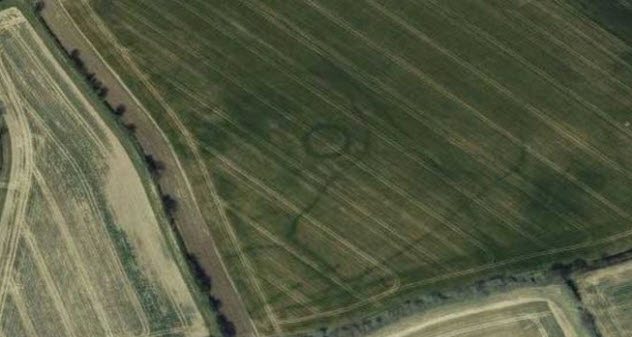
Photo credit: BBC
Gary Campion, 48, from Suffolk County, England, has a hobby of using a metal detector to find hidden treasures. He has even discovered ancient gold coins. Part of his technique in finding potential ancient treasures includes looking at satellite images of his local area with Google Maps. One day, he noticed a mysterious circle and outlined shape that was only visible from an aerial view.
Campion reported what he found to the local Suffolk County Council. The archaeology department was excited to confirm that the shapes he saw are actually burial mounds from 2300–700 BC. Typically, when these sites are excavated, archaeologists find ancient precious metal objects that are auctioned off or displayed in museums.
However, this particular burial site is located on private property. They cannot do an archaeological dig without permission from the owner. Technically, any treasure found on that land would belong to the landowner, and it may be in their best interest not to give away all the objects to a museum for free.[2]
8 Hidden Egyptian Pyramids
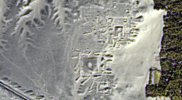
Photo credit: npr.org
The pyramids of Egypt are perhaps the most extravagant tombs ever built. Every massive monument was meant to honor a dead king or queen, and the tombs were filled with treasures that the dead could take with them to the afterlife.
Sarah Parcak from the University of Alabama at Birmingham used satellite images from NASA to find Egyptian pyramids that had never been excavated. In 2011, Parcak discovered 17 new structures in Tanis, Egypt. She also discovered over 1,000 smaller tombs.
Parcak didn’t stop there. She continued to discover more hidden archaeological sites every year. She claims that there are so many hidden ancient ruins that we have only found roughly 10 percent of what’s out there.[3]
Her newest project is hunting for the lost civilizations of Peru. In 2016, she launched a new project called GlobalXplorer, which continues to use satellite images for space archaeology. She encourages anyone to sign up to see if they can find any signs of ancient Peruvian civilizations.
7 The Mass Holocaust Graves In Treblinka
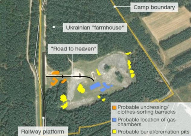
Photo credit: BBC
During the Holocaust, Treblinka was one of the death camps in Poland. In 1943, the Nazis attempted to destroy any evidence that it ever existed. They even took the bricks from the gas chambers and used them for a farmhouse on the land so that they could pretend it was just a farm.
An investigation in 1946 revealed evidence that proved the camp existed in that particular location. When investigators began digging, they found some human bones.[4] But they could never find the bodies dumped in the mass grave that was used when the camp first opened.
In 2010, researchers used modern technology to explore the site even further. They compared an aerial photo taken of the site in 1943 to the modern-day satellite image taken from Google Earth. Using both images, they have mapped out what they believe to be the layout of the death camp. They also used ground-penetrating radar to see if there is any sign of burial sites underneath the ground.
In 2014, a large archaeological dig on the Treblinka site confirmed the location of the mass graves. It also confirmed the exact locations of the gas chambers. The process was filmed in a documentary called Treblinka: Hitler’s Killing Machine for the Smithsonian Channel.
6 Mongolian Tombs
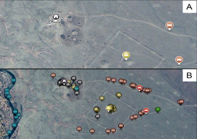
Photo credit: phys.org
Genghis Khan was one of the most ruthless leaders in history. When he died, he wanted to make sure that he could never be found. The rumor was that his tomb was filled with treasure and he wanted to keep it for eternity. Naturally, the hunt for riches has many archaeologists actively searching for the tomb.
The academic journal PLOS ONE decided to take the matter into their own hands. They partnered with National Geographic and the University of California at San Diego to use satellite imaging technology.[5]
Next, they asked 10,000 volunteers to help look through the images to find anything that resembled a tomb. The massive amount of free research helped National Geographic pin down 55 promising sites that appeared to be Bronze Age burial mounds or other ancient sites.
However, the Mongolians were angry that foreign archaeologists wanted to tear apart their country to exhume dead bodies. So far, the location of Genghis Khan’s tomb is still a mystery.
5 An Ancient Mayan City . . . Maybe?
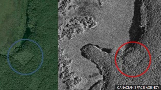
Photo credit: BBC
In 2016, 15-year-old William Gadoury from Canada was fascinated with Mayan culture. He also studied astronomy and realized that the 117 known Mayan cities lined up perfectly with constellations. To test this theory, he used satellite images provided by the Canadian Space Agency to see if he could find an unknown city location in Campeche, Mexico.
Sure enough, there it was—a square indentation covered in vegetation, which indicates that some sort of man-made structure had been built there. However, to fully prove that he has found an ancient Mayan city, Gadoury will need to travel with a team to Mexico and trek into the middle of the jungle. If there really is a hidden city, they will need to spend months uncovering the buildings, tombs, objects, and human remains.
When the news broke about the boy’s discovery, many archaeologists began to bash Gadoury’s claim. They say that the square indentation does not necessarily mean that there is a lost city. National Geographic published some theories from skeptics in the field, mostly claiming that constellations and star maps are a Western concept that the Maya did not understand.
However, Gadoury isn’t shaken by the experts’ criticisms. He believes that they are just threatened by new ideas that challenge their preconceived notions. He still plans to excavate the site with the help of established archaeological teams, and he already has an agreement to publish his findings in an academic journal.[6]
4 Saudi Tombs
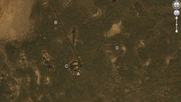
Photo credit: Live Science
Just outside the city of Jeddah in Saudi Arabia, archaeological researcher David Kennedy from the University of Western Australia discovered over 2,000 tombs with Google Earth’s satellite images in 2011. The area where the tombs were discovered is in a dried lava field, which is why people had never stumbled upon the tombs until that point.
Kennedy has been attempting to research Saudi Arabia for years—flying small aircraft in an attempt to find potential archaeological sites. Now, satellite imagery makes the job much easier because everything can be done from the comfort of home.
Though Saudi Arabia has a very old civilization, there has not been an extensive amount of archaeological research in the area. The government of Saudi Arabia doesn’t want any prehistoric evidence to be found.
The Quran claims that the Earth is only a few thousand years old. If evidence is found from ancient civilizations that predates the Quran, it contradicts their religious doctrine.[7] In this case, satellite imagery can only do so much until the archaeologists can get on the ground and start digging.
3 Hidden Tombs In The Dahshur Necropolis
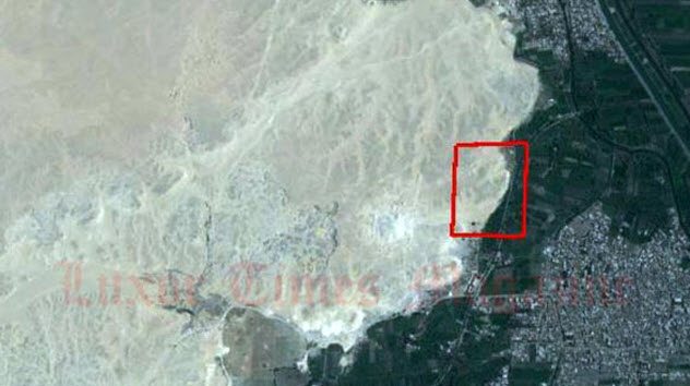
Photo credit: Luxor Times
In Egypt, satellite images are helping archaeologists find more than just royalty. In 2016, Dr. Sarah Parcak used satellites to find the tomb of a man identified as the “royal stamp bearer” in El-Lisht, Egypt.
Parcak and Mohamed Youssef, the antiquities director from the Dahshur necropolis, uncovered the grave marker, which is a large stone slab. Images of the royal stamp bearer’s work and home life were etched into the stone, preserving the story of his life for future generations to see.
This is an important discovery because it gives us more insight into the careers and daily lives of people from the Middle Kingdom (2000–1700 BC). It shows that normal people were also honored and remembered for their work. Parcak is using the satellite images to map entire ancient cities.[8] Soon enough, modern people will have a much greater understanding of ancient Egyptian life.
2 Hidden Graves Of Bosnia
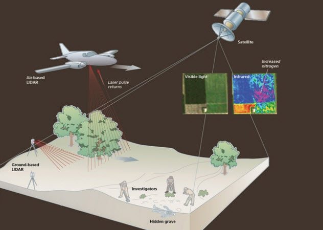
Photo credit: discovermagazine.com
In Bosnia, the International Commission on Missing Persons searched for the remains of people who were killed during the Bosnia-Herzegovina war in the 1990s. During that war, many people went missing. They were buried all over the country and never given grave markers.
It became nearly impossible to find these people and return their remains to their families, who wanted proper burials and closure. The organization attempted to dig up land in places where they theorized that bodies might be found. But unfortunately, they were wrong.[9]
The solution to finding the bodies came from forensic anthropologist Amy Mundorff, who aided in identifying the remains of victims from the 9/11 terrorist attacks. She has studied how plants react to the earth surrounding a buried body and has also helped to develop light detection and ranging technology (LIDAR).
A small airplane uses LIDAR technology to record data on temperature in the area. They also combine the temperature data with high-resolution images from satellites so that they can know details about the terrain.
With this technology, Mundorff hopes to find the victims in Bosnia as well as victims of violent crimes. If bodies are found more quickly with this satellite image/LIDAR combination, it may mean that criminals can be apprehended faster than ever before.
1 The Colootolla Jewish Cemetery
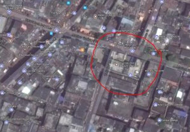
Photo credit: qz.com
In Calcutta, many older cemeteries have disappeared or are hidden in strange and unexpected places. Deepanjan Ghosh, a writer for Quartz India, decided to find some of these hidden cemeteries.
In historic archives, he found an old map of Calcutta from the 1800s that laid out the locations of various burial sites. Using Google Maps, Ghosh brought up modern images of the streets and buildings in the city and aligned them with the historic map. Once he had the modern addresses, he traveled to each location to photograph them for the article.
He found records of a large Jewish cemetery on what was known as Colootolla Street in 1847. It is now called Maulana Shaukat Ali Street. When he arrived, the location had a large commercial building sitting on it.
When Ghosh asked older residents there what had happened to the Jewish cemetery, they replied that the land had been bought, the bodies exhumed, and the structure simply built on top of it. The location is even called “Kabristan Bazar,” which means “Cemetery Market.”[10]
Ghosh contacted the Jewish Board of Calcutta, asking how they felt about one of their burial sites being destroyed. They said that they were not aware of the site’s existence.
Shannon Quinn is a writer and entrepreneur from the Philadelphia area. You can find her on Twitter.
Read more about the bizarre controversies and mysteries surrounding burial sites on Top 10 Bizarre Ways People Have Protected Burial Sites and Top 10 Mysterious Burial Sites.
More Great Lists
") Top 10 Alternatives To Popular Sites And Apps (That…
Top 10 Alternatives To Popular Sites And Apps (That… Top 10 Hidden Features Of Everyday Things
 Top 10 Things Possibly Hidden In The Vatican Secret Archives
 Top 10 Freaky Urban Legends Hidden In Songs
 Top 10 Jaw-Dropping Hidden Spaces In London
 Top 10 Grim Literary Classics With Hidden Whimsical Moments
 Top 10 Stunning Photographs Of Hidden Gem Destinations
 Top 10 Jaw-Dropping Hidden Spaces In Paris
 Top 10 Easter Eggs Hidden in Disney Movies
fact checked by
Jamie Frater
More Great Lists